Categories
Spain, Portugal and Morocco, November 2017

Lunch in the Blue City: Chefchaouen, November 11, 2017

On the afternoon of November 11, 2017, Veterans’ Day in the United States (a holiday which I favor, being a veteran), our Go-Ahead tour group arrived in Chefchaouen, known as the Blue City because many of its buildings are painted in that color. It is usually referred to simply as Chaouen. There are several theories as to how blue came to be the theme color of Chaouen, one being that the color has a special spiritual significance for the locals, another that it is repellent to mosquitoes, and a third, which seems most probable to me, that it was adopted in recent times as way of attracting tourists.

Chaouen is not one of the most ancient cities of Morocco. In the fifteenth century, following the completion of the Reconquista in Portugal, the Portuguese began to take the offensive against the Moors in North Africa. They took a number of cities in northern Morocco, most notably Ceuta and Tangier, and one of the local mujahideen built a small kasbah (fortress) in the Rif Mountains as a stronghold of resistance to the invaders. Over the following years a city grew up around the fortress, its population augmented by Moriscos and Jews expelled from Spain after the fall of Granada in 1492. The influx of immigrants from the Iberian peninsula was the source of a strong Andalusi-Granadan influence on the local culture, manifested most visibly in local residential architecture.

Portuguese imperial ambitions in Morocco were dashed by the Battle of Alcazarquivir in 1578, in which the King of Portugal was killed, ending his dynasty and leading to the takeover of Portugal by Philip II of Spain in 1580. Spanish rule of Portugal and its colonial empire continued until 1540, when the Portuguese rebelled and regained their independence.

Fast forward to the 19th century, when the French were establishing their colonial empire in North Africa. By the end of that century, the Spanish had lost the last of their overseas domains – Cuba and the Philippines – in the Spanish-American War, and were looking for some sort of compensation in order to keep some vestige of their standing among the European powers. Morocco seemed a likely place since so much of it was up for grabs anyway. At the same time, France and Britain took pity on the Spanish and agreed to let them have a few crumbs from the imperial banquet in the form of small slices of Morocco at its northern and southern ends. The arrangement was sealed by the creation of a dual French and Spanish protectorate over the country in 1912. Spain’s slice in the north included the city of Chaouen. The heritage of the Spanish occupation there is most visible in the street names and commemorative plaques, which are generally in Arabic and Spanish (though often in English as well).

The Berber tribes of the Rif Mountains, where Chaouen is located, did not accept Spanish domination passively, and under a capable leader named Abd el-Krim, they rose in revolt, inflicting severe defeats on the Spanish forces. Abd el-Krim established a short-lived government, the Rif Republic, which lasted from 1921 until 1926, when the Spanish finally crushed it with much help from the French. In 1925, at the height of the Rif War, Chaouen was bombarded by the Lafayette Escadrille, a squadron of American mercenary pilots in the service of France.

Francisco Franco rose to prominence during the Rif War, and later, in 1936, launched his uprising against the Spanish Republic from Morocco. The Spanish protectorate in Morocco continued until 1956, when both French and Spanish protectorates were dissolved and merged into the newly independent Kingdom of Morocco. However, Spain did retain the cities of Ceuta and Melilla on the Mediterranean coast.

In the post-World War II era, especially since the 1960s, Chaouen became a popular tourist destination. At first this was primarily associated with the production of cannabis in the Rif; Chaouen emerged as a major hub of cannabis tourism. Cultivated in Morocco for centuries, cannabis was outlawed by King Mohammed V when the country gained independence in 1956. But it was tolerated unofficially to some extent because of its traditional usage by the local population and also because it provided an important source of income for poor farmers of the Rif Mountains, where few other crops can be grown profitably. In recent years, the recognition of the economic value of cannabis has led to its partial decriminalization: in 2021 Morocco declared it legal for medicinal, cosmetic and industrial, though not for recreational purposes. By 2024 Morocco had become the world’s foremost supplier of cannabis. However, I don’t remember seeing any evidence of cannabis commerce in Chaouen, and since I myself am not a cannabis consumer, I didn’t look for it.

Our bus had deposited us in the newer part of Chaouen, through which we had to make our way on foot to the main area of interest, the Chaouen Medina. It was immediately apparent why it was called the Blue City. Not everything was blue, but many of the major structures, such as the wall of the cemetery on Boulevard Hassan II and the local high school, were painted in a bright and deep blue that was quite distinctive, even flamboyant.

Entering the Medina through one of its main gates, the Bab El-Ain, we emerged on the Uta el-Hammam, the main square of the Medina, so named because there is a hammam (public bathhouse) in the northwest corner. There we were able to view the Grand Mosque of Chaouen. Its date of construction is uncertain but is thought to have been in the late 15th or early 16th centuries, though its distinctive octagonal minaret was erected later, sometime in the 17th. As the main mosque of Chaouen, it served as an assembly point where the local notables gathered to make obeisance to the Sultan and where the Sultan’s proclamations were read out to the populace. For me its most striking architectural feature consisted of the blind arches, filled with green-and-white tile inlays, on the sides of what I took to be the prayer hall. The minaret also incorporates blind arches, three tiers of them, with square panels inlaid with zellij tiles on the top tier; for some reason we failed to capture photos of the minaret, but it can be seen here.

We spent some time roaming through the backstreets and alleys of the Medina, where we found ourselves immersed in a sea of blue. Along with Chuck and Elouise Mattox, Sandie and I soon got lost in the maze.

When we finally extricated ourselves, we came out near the main entrance of the Kasbah, the old fortress which was the foundational structure of Chaouen. Next to the entrance there is a historic house which contains some of the archaeological and ethnographic exhibits of the Kasbah, which is now a museum. We did not explore the museum; I think it was closed on the day we were there. On the steps leading to the entrance were piled various household effects such as mattresses, other furniture and crockery. Apparently it was moving day for someone, but who that might be, and whether they were moving into the Kasbah, out of it, or into or out of one of the nearby structures, I was unable to figure out.

Of the native inhabitants of Chaouen, the most memorable for us were the cats. There were a fair number of them inhabiting the Medina, and they seemed to enjoy some sort of privileged or at least well-tolerated status. They mostly looked well-fed and groomed, and they strolled casually around the Uta el-Hammam, without fear or reproach except when tourists crowded in on them; but they seemed to have little trouble coping with that. They even lounged on tabletops in restaurants, which would have been a no-no in an American city.

We continued to roam around the Uta el-Hammam until it was time for lunch. Much of the square was occupied by the souk or bazaar, which was unsurprisingly devoted mostly to tourist-oriented shops and stalls. The wares on display consisted mostly of textiles, clothing, leather goods and ceramics. I was intrigued by some of the offerings, but time was growing short and anyway I had heard that it was advisable to wait until we got to the great entrepot of Fes, our next stop, before splurging on souvenirs.

Every place has its eccentrics, and while wandering around Uta el-Hammam I encountered an old fellow in a Moroccan djellaba (a loose, full-length robe-like garment with a hood) with an unkempt appearance and a glowering, wild-eyed mien. He roamed the crowd, haranguing tourists and locals alike, in what language I don’t know – I could not tell whether it was Arabic or Berber, but it certainly wasn’t French, Spanish or English. His counterpart in an American city would have been carrying a sign that said “Repent! The End of the World is Nigh!” I gave him a few dirhams (Moroccan currency), which he accepted, but that did not soften his tone or his hostile glare, and he went on his way, muttering and grumbling unintelligibly.

We enjoyed our long-awaited and much-needed lunch at Chez Hicham, where we were seated in an upstairs gallery with a superb view of the Uta el-Hammam and the landscape beyond the city. After dining we enjoyed a few more minutes of leisure in the square, enduring the rantings of the aforementioned madman, before it was time to begin the trek back to the bus.

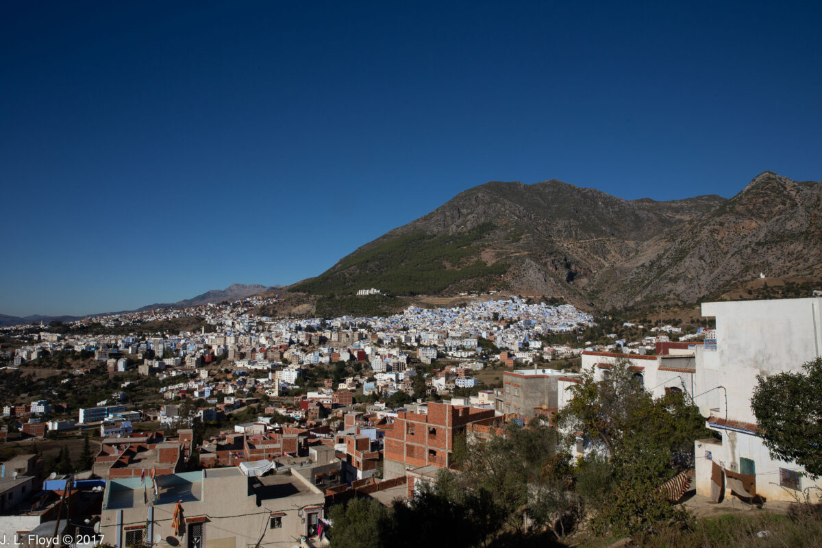
Back in the bus, we began the long journey to Fes. It was soon interrupted by a brief stop just outside Chaouen, at a location which provided a great panoramic overview of the city; I took advantage of the opportunity to catch a few nice shots not only of the town, but also of the immediate surroundings, which included a walled villa with a cute little dog sleeping in its courtyard, oblivious to all the commotion on the highway passing by.

Categories
Spain, Portugal and Morocco, November 2017

Tangier, Morning of November 11, 2017

We had only one morning to spend in Tangier, and we had to make the most of it. Fortunately our Moroccan guide, Karim, and his associates were the right people for the occasion. I can’t speak highly enough of them.

Tangier is a very ancient city with an unusual history, most of which I’m not going to cover here; instead I’ll refer the reader to Wikipedia for the full story. Here I’ll just mention that after centuries of Islamic rule, it was seized by the Portuguese in 1471 and incorporated into their colonial empire. But in 1762, the Portuguese monarchy gifted Tangier to King Charles II of England as part of the dowry of the Infanta (Princess) Catherine of Braganza, whom he married in that year. It proved to be a troubled acquisition, however, because of attacks by mujahideen – Muslim holy warriors determined to expel infidels – and in 1684 the British abandoned it to the locals after destroying as much of it as possible. Subsequently Tangier became a pirate stronghold, and hence a source of irritation to the European powers, who in the 19th century began to eye it once again, along with the rest of Morocco, as an object of possible acquisition. The French established a protectorate over Morocco in 1912, but Tangier was excluded because the rival powers found it too useful as a free-trade city (i.e. tax haven). Instead it became an international city, a nesting-place for all sorts of shady financiers, spies, and smugglers. The creation of the Tangier International Zone in 1924 formalized this arrangement. Eventually, however, with the restoration of Moroccan independence in 1956, Tangier was re-incorporated into that country.

It’s worth noting that the similarity between the name of the city and the fruit known as the tangerine, a form of mandarin orange hybrid, is not accidental, because tangerines were in fact originally developed in the orchards of Tangier. Mass farming of tangerines, however, was only begun in Florida, during the 19th century.

We had to start our morning in Tangier early – around 7 AM, local time. We headed right for the oldest quarter of town, the Medina, entering it via a gateway from the Grand Socco. Officially known as the Place du 9 Avril 1947, this is a historic roundabout square (if that makes any sense) with a large, impressive circular fountain in the middle. It is a lively place, with a number of sidewalk cafes, shops, a movie house called the Cinema Rif, and the Sidi Bou Abid mosque, which I mistook at first for a police station because there were so many police vehicles parked near it (“Really classy police stations in this town,” I thought). Built in 1917, it is distinguished by the liberal use of colorful polychrome tiles, especially on its minaret, and a large clock over its front entrance.

From the Grand Socco we entered the Medina, strolling down its main street, the Rue Siaghine, toward the central square, known as the Petit Socco. The word “socco” is a corruption of the Arabic word “souk,” meaning bazaar or marketplace, familiar to readers of the science-fiction novel Dune. But the entire Medina in effect constituted the marketplace, because the shops lined every street, interspersed with dwellings and other establishments. I felt a particular affinity to one little market that sold nothing but olives, of various kinds and in enormous quantities. This is the real Olive Garden, I thought, and it puts the American restaurant chain of that name to shame. Olives were piled to mountainous heights on its tables.

The most imposing structure in the Medina is the Grand Mosque on Rue de la Marine. From time immemorial it was a site of religious worship, occupied successively by pagan temples, Christian churches and Islamic mosques. When the Portuguese took Tangier in the 15th century, they built a cathedral, which became a mosque again after the British left in 1684. It then fell into decrepitude, but was eventually rebuilt on the order of Sultan Moulay in 1818, and its present form dates from that time. It has been restored and enhanced several times since then, most recently in 2002, and at the time we visited it presented a very attractive appearance. The main portal, in the traditional Islamic horseshoe shape, is surrounded by radiating geometric designs in green, with a carved wooden canopy above. The mosque is graced by an elegant minaret crafted in the traditional Moroccan square shape, of which we would see numerous more examples during our sojourn in that country. Each side, like the main building, was walled with white stucco, framing rectangular inlays of green tile overlain with white stucco latticework and exquisitely sculpted Koranic verses.

From the Grand Mosque we continued down the Rue de la Marine to exit from the Medina on its east side, at the gate known as the Bab Dar Dbagh, where I found a great vantage point from which to capture some captivating views of the Port of Tanger, the harbor and the old city. The older quarters of the city, including the Medina, are situated on a hill overlooking the harbor, with the newer parts of the city located to the east. We descended stairs and steep ramps to a broad terrace bordered by the Avenue Mohammed VI, and shortly arrived at the Restaurante Diblu, where we had an ample breakfast and bid farewell to Tangier.

Boarding the bus which would carry us through the next five days of our Moroccan adventure, we began the drive to our next destination, the Blue City of Chefchaouen. This took us through the Rif Mountains, a rugged and wild area where I expected at any moment to be stopped by bandits or mujahideen, who would hold us for ransom and, since we had no wherewithal to pay the ransom, we would never be heard from again. Fortunately, our only stop turned out to be at a very welcoming establishment called the Salon de Thé, perched above a charming lake surrounded by forested hills all round. There we enjoyed refreshments and relaxing strolls, and took pictures until it was time to resume the journey, which concluded without incident at the azure town which is the subject of my next post.

Categories
Spain, Portugal and Morocco, November 2017 Adventures Abroad

Gibraltar – November 10, 2017

I expected Gibraltar to be somewhat of an anticlimax after the Arabian Nights fantasy of Granada. I knew little about it – a small area with a big rock, familiar from Prudential advertisements, but what else could there be? Quite a lot, as it turns out.

In ancient times Gibraltar was known as Mons Calpe (“Calpe” being a name perhaps of Phoenician origin), and it was considered one of the Pillars of Hercules marking the end of the known world. In 711 CE, a Muslim army led by the Berber commander Tariq ibn Ziyad crossed over from Africa, landed near Mons Calpe and proceeded to conquer the Iberian peninsula from the Germanic Visigoth kingdom, which had dominated the area since the fall of the Western Roman Empire. After that, Mons Calpe became known as Jabal Tariq, “the mount of Tariq,” a name subsequently corrupted by the Spaniards to Gibraltar.

The Moors controlled Gibraltar for hundreds of years, until their grip on the area began to loosen in the late Middle Ages. It finally came under the control of the Castilians in 1462, and remained so until 1704, when an Anglo-Dutch force captured it in the War of the Spanish Succession. The Treaty of Utrecht, which ended that war in 1713, left Gibraltar permanently in the hands of the British. Sovereignty over Gibraltar remains a sore point in relations between Britain and Spain; but the British refuse to discuss the issue unless the Gibraltarians themselves are allowed a say in the matter, and this the Spanish do not find acceptable. The Gibraltarians themselves voted decisively in 2002 to reject union with Spain. So Gibraltar remains under British rule to this day. But Gibraltar has its own Parliament and a degree of self-government.

Gibraltar is a tiny territory, with an area of 6.8 square kilometers or 2.6 square miles, and a population of around 32,000. But it has a vibrant economy and its importance in international trade far exceeds its size.

Thus, when entering Gibraltar we had to pass through an international border station complete with customs checks. These did not delay us for long, however, and soon we were back on our bus.

Threading its way through the tightly woven streets of Gibraltar town, our tour bus took us first to the southernmost tip of the peninsula, Europa Point. This is a picturesque place where the Alboran Sea, the westernmost part of the Mediterranean, meets the Strait of Gibraltar. On the way we drove through one of the many road tunnels bored into the side of the Rock and passed an artificial waterfall created by the desalinization plant which provides Gibraltar town with all of its fresh water. We were also able to catch sight of a squarish tower atop the Rock which turned out to be the Tower of Homage of the Moorish Castle, the most conspicuous legacy of the Islamic period in Gibraltar. Construction of the Moorish Castle was begun in the 8th century, not long after the initial conquest of the Iberian peninsula, but the Tower of Homage and other prominent parts of the castle as seen today are the product of a later era. In 1309 the Castilians took control of Gibraltar, then held by the Marinids, a North African Berber power, but the Marinids reconquered it in 1333 and, to solidify their hold on the Rock, they rebuilt and strengthened the castle, with the Tower of Homage as its most prominent feature. Although the Castilians expelled the Marinids from the Iberian peninsula in 1344, they did not then regain Gibraltar, which passed to the Nasrids of Granada until 1462, when Juan Alonso de Guzman, the first Duke of Medina Sidonia, finally took it for Castile, thirty years before Granada itself finally surrendered to the Spanish.

We were fortunate to arrive at Europa Point on a clear day, because we had wonderful unobstructed views of the Rock of Gibraltar to the north, the Bay of Gibraltar to the west, and to the south, the coast of Africa, including the town of Ceuta and the Rif Mountains of Morocco.

Europa Point is the site of an abundance of attractions, one of which is a famous old lighthouse, built in 1841 and variously known as the Trinity Lighthouse after the company which operates it, the Victoria Tower, La Farola (“lamppost” in Spanish) or simply the Europa Point Lighthouse. It is 20 meters (66 feet) high and is a working lighthouse, using the latest LED lighting technology.

Over the centuries of their tenure the British augmented the old Moorish and Spanish fortifications with their own, including a plethora of cannon installed in batteries in various locations around the peninsula. The archetype is Harding’s Battery at Europa Point, named after George Harding, Chief Engineer in 1844 and a hero of the Napoleonic Wars. Built in 1859, the battery was equipped in 1878 with a 12.5 inch 38-ton Rifled Muzzle Loading cannon firing 800-pound projectiles. This was obsolete by World War II, when it was replaced by 40mm anti-aircraft guns; and after the war the battery was abandoned altogether. But the site was restored in 2010 as part of a tourism-driven makeover of Europa Point, and the old magazine below the gun platform was converted into a Visitor Center with local history displays. As a crowning achievement a twin of the original 12.5 inch cannon was found, restored and installed back on the gun platform.

Europa Point seemed an odd place to find one of the most striking mosques we saw on our trip, but it is indeed the location of the Ibrahim al-Ibrahim Mosque, also known as the King Fahd bin Abdulaziz al-Saud Mosque after its donor, the late king of Saudi Arabia. It was completed in 1997 at a cost of £5 million. Muslims living in Gibraltar number about 1,000 and constitute 4% of the local population. Viewed against the backdrop of the Rock of Gibraltar from the south, at the very end of Europa Point, it is a spectacular sight.

From Europa Point our tour bus climbed up the steep switchback roads on the sides of the Rock, from which we had superb views of the harbor and the Straits. Our destination was St. Michael’s Cave, entry to which was high up on the Rock. Upon debarking from the bus, we encountered a troop of Barbary Apes, which are actually monkeys, of a type known as macaques. Their particular species is known as Macacus silvanus, and they are native to Africa, where they live mainly in the Atlas and Rif Mountains of Algeria and Morocco. Other than humans, they are the only wild primates living on the European continent. Their numbers are declining in Africa, but increasing on Gibraltar, where their troops must be periodically culled to avoid putting excessive pressure on the frail and limited habitat. Culling in this case means relocating selected numbers to places like the Atlas Mountains (their native habitat) or to zoos in Scotland, Australia and elsewhere. There is a legend that British rule in Gibraltar will continue as long as the macaques survive there; Winston Churchill took this seriously enough so that when the population shrank to only 7 during World War II, because of Axis bombing and other harassments, he directed that measures be taken to replenish them by kidnaping some from Algeria, so it’s kind of ironic that some now have to be sent back to Africa. They now number about 300, distributed among five troops. I have also read, though I’ve forgotten where, that during one of the 18th-century sieges when the Spanish mounted a stealth night attack to retake Gibraltar from the British, the macaques raised the alarm, waking the defenders in time to form up and repulse the onslaught.

St. Michael’s Cave is actually one of many caves on the Rock, some of which served as homes to prehistoric humans, e.g. the Neanderthals, about 50,000 years ago, and later on Homo Sapiens. With the advent of agriculture, people stopped living in the caves, settling in the Gibraltar Campo (hinterland) instead, but the Gibraltar caves continued to be used as religious shrines and hideouts in times of trouble.

St. Michael’s Cave was named after a similar cave system in Italy where the Archangel Michael was said to have appeared, and it is the most visited of the Gibraltar caves (1 million per year). Its entrance is 300 meters or 980 feet high on the western face of the Rock, with breathtaking views of the harbor area.

Upon entering St. Michael’s we shortly found ourselves in its largest chamber, the Cathedral Cavern, which has been converted into a concert hall and auditorium owing to its extraordinary acoustic properties. It has a concrete stage and a seating capacity of over 100. In addition to concerts of all known genres of music, the hall hosts plays and an annual beauty pageant. In the auditorium, as well as the other chambers we traversed, colorful lighting is used to enhance the experience.

The remaining chambers on our path through St. Michael’s, though smaller, were no less splendid than the Cathedral, and bore colorful names such as the Den of Dagon, the Blue Palace, the Chamber of Cthulhu, the Mouth of Hades, etc. Actually you won’t find most of these names on the St. Michael’s signboards because I made them up; however, I think they are quite appropriate.

If I recall correctly, the Den of Dagon is a name that I did not make up; if I had done so, I would have called it Batman’s Cave.

The lighting effects in some cases morphed the stalactites and stalagmites in the cavern into weird phantasmagoric shapes, to which I also gave names, such as the Hanging Dishtowel and the Violet Fountain.

Emerging back into the light of day, we encountered more of the Barbary nacaques; some of them were lounging nonchalantly on what looked like extremely uncomfortable and dangerous perches on the railings at the edge of a 2,000 foot dropoff, some were apparently practicing yoga, and one pair was studying a group of humans intently, with the obvious purpose of gathering data for anthropological monographs.

We continued to enjoy the views for a while before boarding the bus again for the descent to the harbor. Nearby the cave exit runs a cable railway which carries visitors from sea level to the top of the Rock, and I regretted that our stay was too short to allow us to take advantage of it and to see the remaining attractions, such as the Moorish Castle and the Great Siege Tunnels. The latter were constructed during the Great Siege of 1779-1883, when French and Spanish forces, fighting with the Americans during the Revolutionary War, attempted to take Gibraltar from the British. The British defenders needed to place artillery on the north side of the Rock to cover all possible approaches across the isthmus separating Gibraltar from Spanish territory, but one vital location was inaccessible because of the steep terrain, so they dug a tunnel to it instead. (The siege ultimately failed, of course.)

But now the afternoon was wearing on, and we had a major transfer coming up – not only to another city, another country, but even to another continent. This would be the first time I had ever set foot in Africa. (Sandie had been to Egypt in the 70s.) Our bus took us down to the Port of Gibraltar, where we boarded a large and comfortable ferryboat heading for Tangier. The voyage from Gibraltar to Tangier takes about an hour and a half. When we arrived in Tangier it was still daylight, but we found that there was some construction going on at the ferry terminal, which meant that the bus had to park in a temporary lot some distance away. We not only had to walk the entire way, we also had to haul our luggage. I’m not sure how far it was to the bus, but it seemed like at least a mile to us in our condition, and by the time we arrived it was dark and we were exhausted. The bus whisked us off to the Hilton Garden Hotel, and after a quick dinner we all fell gratefully into bed and slept the sleep of the near-dead.