I expected Gibraltar to be somewhat of an anticlimax after the Arabian Nights fantasy of Granada. I knew little about it – a small area with a big rock, familiar from Prudential advertisements, but what else could there be? Quite a lot, as it turns out.
In ancient times Gibraltar was known as Mons Calpe (“Calpe” being a name perhaps of Phoenician origin), and it was considered one of the Pillars of Hercules marking the end of the known world. In 711 CE, a Muslim army led by the Berber commander Tariq ibn Ziyad crossed over from Africa, landed near Mons Calpe and proceeded to conquer the Iberian peninsula from the Germanic Visigoth kingdom, which had dominated the area since the fall of the Western Roman Empire. After that, Mons Calpe became known as Jabal Tariq, “the mount of Tariq,” a name subsequently corrupted by the Spaniards to Gibraltar.
The Moors controlled Gibraltar for hundreds of years, until their grip on the area began to loosen in the late Middle Ages. It finally came under the control of the Castilians in 1462, and remained so until 1704, when an Anglo-Dutch force captured it in the War of the Spanish Succession. The Treaty of Utrecht, which ended that war in 1713, left Gibraltar permanently in the hands of the British. Sovereignty over Gibraltar remains a sore point in relations between Britain and Spain; but the British refuse to discuss the issue unless the Gibraltarians themselves are allowed a say in the matter, and this the Spanish do not find acceptable. The Gibraltarians themselves voted decisively in 2002 to reject union with Spain. So Gibraltar remains under British rule to this day. But Gibraltar has its own Parliament and a degree of self-government.
Gibraltar is a tiny territory, with an area of 6.8 square kilometers or 2.6 square miles, and a population of around 32,000. But it has a vibrant economy and its importance in international trade far exceeds its size.
Thus, when entering Gibraltar we had to pass through an international border station complete with customs checks. These did not delay us for long, however, and soon we were back on our bus.


Threading its way through the tightly woven streets of Gibraltar town, our tour bus took us first to the southernmost tip of the peninsula, Europa Point. This is a picturesque place where the Alboran Sea, the westernmost part of the Mediterranean, meets the Strait of Gibraltar. On the way we drove through one of the many road tunnels bored into the side of the Rock and passed an artificial waterfall created by the desalinization plant which provides Gibraltar town with all of its fresh water. We were also able to catch sight of a squarish tower atop the Rock which turned out to be the Tower of Homage of the Moorish Castle, the most conspicuous legacy of the Islamic period in Gibraltar. Construction of the Moorish Castle was begun in the 8th century, not long after the initial conquest of the Iberian peninsula, but the Tower of Homage and other prominent parts of the castle as seen today are the product of a later era. In 1309 the Castilians took control of Gibraltar, then held by the Marinids, a North African Berber power, but the Marinids reconquered it in 1333 and, to solidify their hold on the Rock, they rebuilt and strengthened the castle, with the Tower of Homage as its most prominent feature. Although the Castilians expelled the Marinids from the Iberian peninsula in 1344, they did not then regain Gibraltar, which passed to the Nasrids of Granada until 1462, when Juan Alonso de Guzman, the first Duke of Medina Sidonia, finally took it for Castile, thirty years before Granada itself finally surrendered to the Spanish.
We were fortunate to arrive at Europa Point on a clear day, because we had wonderful unobstructed views of the Rock of Gibraltar to the north, the Bay of Gibraltar to the west, and to the south, the coast of Africa, including the town of Ceuta and the Rif Mountains of Morocco.


Europa Point is the site of an abundance of attractions, one of which is a famous old lighthouse, built in 1841 and variously known as the Trinity Lighthouse after the company which operates it, the Victoria Tower, La Farola (“lamppost” in Spanish) or simply the Europa Point Lighthouse. It is 20 meters (66 feet) high and is a working lighthouse, using the latest LED lighting technology.
Over the centuries of their tenure the British augmented the old Moorish and Spanish fortifications with their own, including a plethora of cannon installed in batteries in various locations around the peninsula. The archetype is Harding’s Battery at Europa Point, named after George Harding, Chief Engineer in 1844 and a hero of the Napoleonic Wars. Built in 1859, the battery was equipped in 1878 with a 12.5 inch 38-ton Rifled Muzzle Loading cannon firing 800-pound projectiles. This was obsolete by World War II, when it was replaced by 40mm anti-aircraft guns; and after the war the battery was abandoned altogether. But the site was restored in 2010 as part of a tourism-driven makeover of Europa Point, and the old magazine below the gun platform was converted into a Visitor Center with local history displays. As a crowning achievement a twin of the original 12.5 inch cannon was found, restored and installed back on the gun platform.
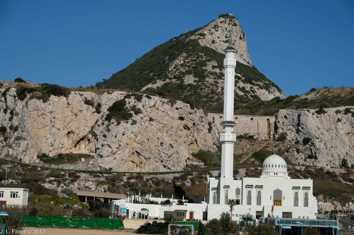
Europa Point seemed an odd place to find one of the most striking mosques we saw on our trip, but it is indeed the location of the Ibrahim al-Ibrahim Mosque, also known as the King Fahd bin Abdulaziz al-Saud Mosque after its donor, the late king of Saudi Arabia. It was completed in 1997 at a cost of £5 million. Muslims living in Gibraltar number about 1,000 and constitute 4% of the local population. Viewed against the backdrop of the Rock of Gibraltar from the south, at the very end of Europa Point, it is a spectacular sight.


From Europa Point our tour bus climbed up the steep switchback roads on the sides of the Rock, from which we had superb views of the harbor and the Straits. Our destination was St. Michael’s Cave, entry to which was high up on the Rock. Upon debarking from the bus, we encountered a troop of Barbary Apes, which are actually monkeys, of a type known as macaques. Their particular species is known as Macacus silvanus, and they are native to Africa, where they live mainly in the Atlas and Rif Mountains of Algeria and Morocco. Other than humans, they are the only wild primates living on the European continent. Their numbers are declining in Africa, but increasing on Gibraltar, where their troops must be periodically culled to avoid putting excessive pressure on the frail and limited habitat. Culling in this case means relocating selected numbers to places like the Atlas Mountains (their native habitat) or to zoos in Scotland, Australia and elsewhere. There is a legend that British rule in Gibraltar will continue as long as the macaques survive there; Winston Churchill took this seriously enough so that when the population shrank to only 7 during World War II, because of Axis bombing and other harassments, he directed that measures be taken to replenish them by kidnaping some from Algeria, so it’s kind of ironic that some now have to be sent back to Africa. They now number about 300, distributed among five troops. I have also read, though I’ve forgotten where, that during one of the 18th-century sieges when the Spanish mounted a stealth night attack to retake Gibraltar from the British, the macaques raised the alarm, waking the defenders in time to form up and repulse the onslaught.


St. Michael’s Cave is actually one of many caves on the Rock, some of which served as homes to prehistoric humans, e.g. the Neanderthals, about 50,000 years ago, and later on Homo Sapiens. With the advent of agriculture, people stopped living in the caves, settling in the Gibraltar Campo (hinterland) instead, but the Gibraltar caves continued to be used as religious shrines and hideouts in times of trouble.
St. Michael’s Cave was named after a similar cave system in Italy where the Archangel Michael was said to have appeared, and it is the most visited of the Gibraltar caves (1 million per year). Its entrance is 300 meters or 980 feet high on the western face of the Rock, with breathtaking views of the harbor area.
Upon entering St. Michael’s we shortly found ourselves in its largest chamber, the Cathedral Cavern, which has been converted into a concert hall and auditorium owing to its extraordinary acoustic properties. It has a concrete stage and a seating capacity of over 100. In addition to concerts of all known genres of music, the hall hosts plays and an annual beauty pageant. In the auditorium, as well as the other chambers we traversed, colorful lighting is used to enhance the experience.


The remaining chambers on our path through St. Michael’s, though smaller, were no less splendid than the Cathedral, and bore colorful names such as the Den of Dagon, the Blue Palace, the Chamber of Cthulhu, the Mouth of Hades, etc. Actually you won’t find most of these names on the St. Michael’s signboards because I made them up; however, I think they are quite appropriate.
If I recall correctly, the Den of Dagon is a name that I did not make up; if I had done so, I would have called it Batman’s Cave.


The lighting effects in some cases morphed the stalactites and stalagmites in the cavern into weird phantasmagoric shapes, to which I also gave names, such as the Hanging Dishtowel and the Violet Fountain.


Emerging back into the light of day, we encountered more of the Barbary nacaques; some of them were lounging nonchalantly on what looked like extremely uncomfortable and dangerous perches on the railings at the edge of a 2,000 foot dropoff, some were apparently practicing yoga, and one pair was studying a group of humans intently, with the obvious purpose of gathering data for anthropological monographs.


We continued to enjoy the views for a while before boarding the bus again for the descent to the harbor. Nearby the cave exit runs a cable railway which carries visitors from sea level to the top of the Rock, and I regretted that our stay was too short to allow us to take advantage of it and to see the remaining attractions, such as the Moorish Castle and the Great Siege Tunnels. The latter were constructed during the Great Siege of 1779-1883, when French and Spanish forces, fighting with the Americans during the Revolutionary War, attempted to take Gibraltar from the British. The British defenders needed to place artillery on the north side of the Rock to cover all possible approaches across the isthmus separating Gibraltar from Spanish territory, but one vital location was inaccessible because of the steep terrain, so they dug a tunnel to it instead. (The siege ultimately failed, of course.)


But now the afternoon was wearing on, and we had a major transfer coming up – not only to another city, another country, but even to another continent. This would be the first time I had ever set foot in Africa. (Sandie had been to Egypt in the 70s.) Our bus took us down to the Port of Gibraltar, where we boarded a large and comfortable ferryboat heading for Tangier. The voyage from Gibraltar to Tangier takes about an hour and a half. When we arrived in Tangier it was still daylight, but we found that there was some construction going on at the ferry terminal, which meant that the bus had to park in a temporary lot some distance away. We not only had to walk the entire way, we also had to haul our luggage. I’m not sure how far it was to the bus, but it seemed like at least a mile to us in our condition, and by the time we arrived it was dark and we were exhausted. The bus whisked us off to the Hilton Garden Hotel, and after a quick dinner we all fell gratefully into bed and slept the sleep of the near-dead.


