Rabat is the political capital of Morocco, and has been effectively so since 1912, when the French established their protectorate and made Rabat the seat of their administration for safety’s sake, Fes being too unruly and hostile to infidels. After Morocco regained full independence in 1956, the monarchy, perhaps for similar reasons, continued to rule from Rabat. It was a smaller city than Fes, less xenophobic and easier to control.
We visited Rabat on November 13, 2017, on our way from Fes to Casablanca, spending most of the day there. I knew little about Rabat in advance and thus was pleasantly surprised at what we saw there, much more than what I expected. I did not know, for example, that Rabat has been around a long time, under different names; it probably began as Shallat, a Phoenician colony, early in the first millenium BCE, and in the first century BCE it came into the orbit of Rome. Under the name of Sala Colonia, it became a naval outpost and commercial trading waystation. After Roman times it became abandoned, but underwent a revival in the Islamic era. In the 10th century CE a ribat (Arabic word for small frontier outpost) was built on the south side of the Bou Regreg River, and later a new town of Sala, now known as Salé, was built on the north side of the Bou Regreg River (Roman Sala Colonia had been on the south side). In 1150 or 1151 the Almohad caliph Abd al-Mu’min built a full-scale kasbah, or fortress, on the site of the old ribat, but the city eventually derived its name from the older title, because it’s now Rabat instead of Kasbah.
In 1244 the new Marinid dynasty replaced the Almohads and ruled Morocco until it was in turn overthrown by the Wattasids in the 15th century. The Marinids made their capital at Fes, but they built a new mosque, as well as a major necropolis, called the Chellah (which we visited), in Rabat.
In 1609 the Spanish monarch Philip III (who also controlled Portugal at the time) decreed the expulsion of all the Moriscos – people of Muslim or Moorish descent – from the Iberian peninsula. (The Spanish had promised to allow them to continue to practice their religion after the conquest of Granada in 1492, but Cardinal Ximenes had reneged on the deal.) Many of the Moriscos landed in the vicinity of Rabat, which underwent a substantial growth in population a result. Perhaps in order to revenge themselves on their former persecutors, as well as to augment their incomes, some of these immigrants turned to piracy.
By the early 17th century the Saadian Sultanate, which had replaced the Wattasids in the early 16th, was on the skids, and its control over the area at the mouth of the Bou Regreg River was falling apart. The Moriscos and other inhabitants of Rabat – then known as Old Salé, with the town on the north side of the river called New Salé – established an autonomous polity known as the Republic of Salé, or Republic of Bou Regreg, which became a haven of pirates. The corsairs preyed on merchant shipping around the shores of Western Europe, seizing the cargoes and selling the crews and passengers into slavery in the Islamic world. Although a new dynasty, the ‘Alawis, came to power and took control of the Salé area in 1666, they allowed the depredations of the pirates to continue until the early 19th century. I suspect that they got a share of the spoils.
While maintaining their capital in Fes, the ‘Alawis took considerable interest in Rabat and undertook several building projects there, expanding the kasbah and building new palaces and mosques. Sultan Moulay Isma’il (r. 1672–1727) settled members of the Udayas, a tribe that furnished part of his army, in the kasbah, so that now it is known as the Kasbah of the Udayas (which we also visited).
In 1755 the enormous earthquake that destroyed Lisbon also wreaked havoc in Rabat, seriously damaging the Chellah necropolis, the Roman ruins and other historic structures as well.
When the joint French/Spanish protectorate of Morocco was established in 1912, the ‘Alawi Sultan Abd al-Hafid abdicated and was replaced by his brother Yusuf, the candidate of the French. Under French colonial rule the Sultan retained some of his prerogatives but was basically the puppet of the French government. However, in 1927 Yusuf died and was succeeded by Mohammed V, who increasingly became associated with a growing nationalist movement. After World War II Mohammed V, encouraged by token support from the USA, became increasingly vocal in his support of the movement, and altercations with the French government became more serious and violent. In 1953 the French attempted to neutralize the Sultan by exiling him to Madagascar, but this failed to defang the nationalist movement and agitation for independence only increased. By 1955 the French were ready to throw in the towel and allowed Mohammed V to return to Rabat, greeted by cheering crowds, in October of that year. In 1956 the signing of a Moroccan declaration of independence officially ended French rule in Morocco. A year later, Mohammed V exchanged the title of Sultan for that of King, and his successors have continued as Kings ever since.
After Morocco regained independence in 1956, Rabat – although still only the seventh largest city in Morocco – grew to a population of 577,827 in 2014; but the conurbation it forms together with the surrounding cities of Salé (890,403), Kenitra (431,282), and Temara (313,510) totals over 2 million.
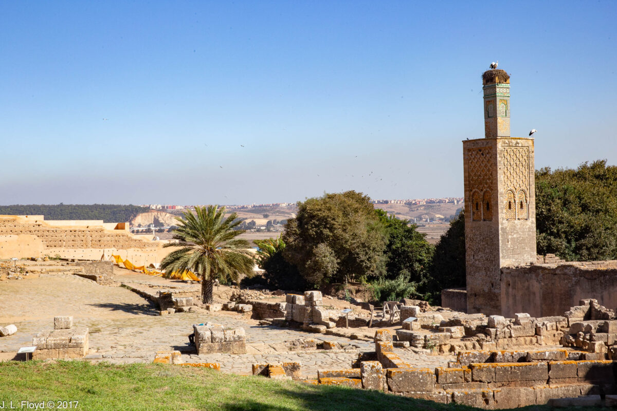
Our visit to Rabat started at the Chellah. It is enclosed by a set of walls built by the Marinid sultans in the 14th century. We entered through the monumental main gate, completed in 1339 by the Marinid Sultan Abu al-Hasan. The elaborately decorated gate with its horseshoe arch and polylobed motifs is flanked by two towers with semi-octagonal bases and crowned with square turrets, and guarded by two tribesmen dressed in colorful red and green costumes. After passing through the gate, we strolled through a garden area through which we glimpsed a towering minaret with a stork’s nest on top.


The minaret beckoned us to the ruins of the Marinid necropolis (known as a khalwa in Arabic), which we explored first, beginning with the mosque, built around 1284-85 by the Marinid Sultan Abu Yusuf Ya’qub (not to be confused with Caliph Abu Yusuf Ya’qub al-Mansur of an earlier dynasty, the Almohads). It is a hypostyle hall (i.e. has rows of columns supporting the roof) divided into three naves by two rows of horseshoe arches. At the rear of the mosque are several qubba (tombs or mausoleums), the most elaborate and well-preserved of which is that of Abu al-Hasan, who reigned from 1331 to 1348. His qubba was likely built by his son, Abu Inan, who also may have built the adjoining madrasah and the tall minaret.


Not only the minaret, but also the mausoleum of Abu al-Hasan, the walls of the madrasah and virtually every other tall structure in the necropolis were appropriated by storks as nesting sites. I was reminded of a madrasah in another Muslim city, Bukhara in Uzbekistan, where I stayed in 1973 and which was also topped by a stork’s nest, although it was unoccupied at the time. The nests in the Chellah were fully occupied; the residents, who are of the type known as white storks (though they have wings that are partly black), spend the summer in Europe and in autumn fly across the Straits of Gibraltar to Morocco, where they spend the winter. I love these magnificent creatures, and I was gratified that the custodians of the Chellah made them welcome.


Opposite the necropolis, on the north side of the Chellah, we strolled amidst the ruins of the ancient Roman town, Sala Colonia. This was built on a slope and was laid out in three terraces, with streets laid out in a regular grid. At its west end stood the capitolium, a temple dedicated to the Capitoline Triad, a group of deities which included Jupiter, Juno and Minerva and occupied a central role in Roman religion. It was better preserved than some of the other structures, including a row of tabernae (shops) on its south side, which had collapsed, and a triumphal arch nearby, of which only the foundations remain. South of them, next to the Marinid necropolis, was another set of ruined structures, which included the Roman bathhouse, a nymphaeum (temple dedicated to nymphs) and a basilica (civic structure, like a city hall). Most of these have been dated to the early second century CE, a time of great prosperity for the Roman Empire.
At the east end of the Sala Colonia complex we investigated the old Roman Forum area, which also includes a temple and some tabernae. Its age has not been precisely determined, but it may be older than the west-end structures, possibly dating from from just before or after Rome annexed the area in 40 CE. In the forum we found some ruined statues, one of which Manuel Sueiras, our tour leader, adapted for use as a podium from which to harangue us on various subjects (mostly the necessity of sticking to the tour schedule and not being late for the bus). I thought of him as the simulacrum of Emperor Trajan, the great second-century CE monarch who presided over the Roman Empire at its apogee. This was quite appropriate because Trajan, like Manuel, was from Spain. Manuel was followed at the podium by Chuck Mattox, whom I imagined as playing the role of Mark Antony rallying the crowd at Julius Caesar’s funeral with the speech that (at least according to Shakespeare) begins with “Friends, Romans, countrymen, lend me your ears.”


Leaving the Chellah, we rode the bus a short distance to a wide esplanade where we visited the next couple of attractions, the Hassan Tower and the Mausoleum of King Mohammed V. Guarding the entrance to the complex were a couple of elite Moroccan lancers in colorful red uniforms mounted on white horses.
Nobody seems to know how the Hassan Tower got its name, because it was not built by anyone named Hassan. Its sponsor was the Almohad ruler Abu Yusuf Ya’qub al-Mansur (r. 1184 to 1199), who wanted to move his capital from Marrakesh to Rabat and make the latter into an imperial capital with the largest and most magnificent mosque in the Maghreb. He actually started construction on the mosque in 1191, but when he died work stopped and was never resumed. All that remains are parts of the walls, a forest of columns intended to hold up the roof, and the partially completed minaret, 44 meters (144 feet) out of a planned 64 meters (210 feet) or more in height. That unfinished minaret is the Hassan Tower. Its footprint is square, 16 meters on a side, and it is built of sandstone which has turned a reddish color over the centuries. One curious fact about the Tower is that there are no stairs to climb to the top; instead there are a series of ramps – this was done so that the muezzin could ride horseback up to the top to do the daily prayers.


On the south side of the mosque esplanade stands a modern complex of structures, consisting of a modern mosque, a pavilion, and the Mausoleum of Mohammed V. These were designed by a Vietnamese architect, Cong Vo Toan, and completed in 1971. The mausoleum is at the southeastern corner of the esplanade.
King Hassan II (r. 1961-1999) commissioned the mausoleum after the death of his father, Mohammed V, in 1961, and was later himself buried in it as well, along with his younger brother Abdallah, who died of cancer in 1983. The mausoleum stands on a raised platform, accessed by a long flight of steps, and is built of reinforced concrete, but is clad in white marble, with porticos of Moorish arches holding up the walls. A pyramidal green dome sits atop the roof with its crenellated parapets.
Venturing into the mausoleum, we found ourselves in an upstairs gallery which extends along all four sides of a rectangular chamber, looking down into the burial vault. The tomb of Mohammed V is carved in white onyx and illuminated by lamps in chased brass vessels which cast a soft light over the room. In one corner stands a reading platform holding a copy of the Quran, where a reader can come and recite its verses. Elegant zellij tiles cover the walls, and a polished mahogany dome with colored glass presides over the chamber.
At the opposite side of the esplanade, in the southwestern corner, is a rectangular open-air pavilion with rows of arches, built on a raised platform; this was designed as a museum to showcase the achievements of the current ruling house of Morocco, the Alawites (or Alaouites). Between the pavilion and the mausoleum stands the modern mosque, which we did not enter.


Our itinerary took us finally to the Kasbah of the Udayas, our last stop in Rabat. The Almohad ruler Abu Yusuf Ya’qub al-Mansur, who wanted to make Rabat his imperial capital, built several new ornamental gates in the walls of the Kasbah, most notably the Bab Oudaia, also known as the Bab al-Kbir, which translates to “Great Gate.” It is indeed impressive, but for some reason I failed to obtain a good photo of it, though I did photograph some of the other gates. However, you can find good shots of the Bab al-Kbir on Wikipedia.


Immediately upon entering the Kasbah we discovered that Rabat is another Blue City, reminiscent of Chaouen. The walls are painted blue and white, and many of the doors and windows are blue also. The streets of the Kasbah, especially in the residential areas, were generally very narrow, as one would expect in a medieval walled city. However, they were neat and clean and the residents obviously took pride in their dwellings. Moreover, street lights had been installed to improve safety at night.


There was little opportunity for ostentatious display given the uniform character of the residential structures; what conspicuous consumption there was – and individual creativity as well – showed up mostly in and around the doors, some of which were quite remarkable. Sandie and I shot photos of some of the more striking ones, as seen in the next gallery.


In the 17th century the corsairs who then controlled the Kasbah built a broad platform on its northeastern edge, from which they could signal by semaphore to their own ships and repel pursuing enemy ships with artillery. Today the platform provides scenic views of the Rabat waterfront, the Bou Regreg river, the city of Salé across the river, and the Atlantic Ocean beyond. The jetties at the harbor mouth provide protection against the ravages of the tumultuous Atlantic Ocean and form a nice beach; a set of broad steps leads down from the Kasbah to the beach.


We did not spend the night in Rabat, instead boarding the bus to continue to Casablanca, Morocco’s largest city, where we were booked for dinner at Rick’s Café that evening.