The Wachau Valley lies between the city of Krems and the town of Melk, a distance of only 36 kilometers or 22 miles. It takes only a half-hour to drive 31 kilometers by automobile from D
It’s easy to get around in the Wachau Valley; several means of transportation are available. Major highways and rail lines run from Vienna to Krems and Melk. Within the valley, the Donau Bundesstrasse B3 runs from Krems to Melk on the north bank, while another highway, the Aggsteiner Strasse, runs along the south bank. Both have associated bike paths; the ride from Melk to Krems is said to take 3-4 hours, but that is mostly downhill – the ride in the opposite direction would take much longer. We saw many bicyclists on the way from D
The Donau Bundesstrasse is part of the Austrian Romantic Route, a 380-kilometer route which runs from Vienna to Salzburg. To avoid cutting through the heart of D


Not surprisingly, since we were doing it ourselves, waterborne travel is one of the major modes of transportation in the Wachau Valley. In addition to cruise lines such as Gate1 and Ama Waterways, there are regularly scheduled services between the major towns and “theme trips” available for short-distance day excursions.
But the transport mode that caught our attention most dramatically on our journey through the Wachau was the one used to cross the river rather than follow it: cable ferries. There are no bridges over the Danube in the Wachau Valley, so these ferries are the only way to cross. In my experience they are unique. The ferryboats have neither motors nor sails (nor for that matter, oars). They have only a rudder, which is set at an angle to the river current, and the energy of the current against the rudder is what propels the ferryboat. The boat is prevented from moving downstream by being tethered to an overhead cable, strung across the river and anchored to towers on either side. This struck me as being quite an eco-friendly and energy-efficient mode of transportation and I wondered why I haven’t seen it elsewhere.


The first cable ferry we encountered was at Weissenkirchen, 6 kilometres (3.7 mi) up the Danube from Dürnstein. Weißenkirchen in der Wachau, to give it its full authentic name in German spelling, is a village of about 1600 people right in the middle of the most prolific wine-producing area of the Wachau Valley. It is also the setting of the Teisenhoferhof, a structure originally built in Gothic style as part of the fortifications of the nearby church in the 14th century, when it served as a crossbow-shooting range. In 1542, however, it was expanded with an arcaded courtyard in the Renaissance style, and today it is considered one of the most beautiful courtyards in Austria. It is a popular venue for concerts, plays and other cultural events, especially wine festivals. It also hosts the Wachau Museum and an art gallery.
The Weissenkirchen parish church – for which I suspect the village is named – is a striking structure, easily the most prominent landmark in the village, with its steep red roof and soaring square tower. It was built in the 14th century, although its origins date from much earlier. Another highly visible landmark is a brilliant white chateau or mansion on a hill to the northeast of the church; but I was unable to identify it from the map, and since we didn’t stop at Weissenkirchen, I couldn’t find anyone who could tell me about it. I guess I’ll have to go back to Weissenkirchen sometime and find out what it is.


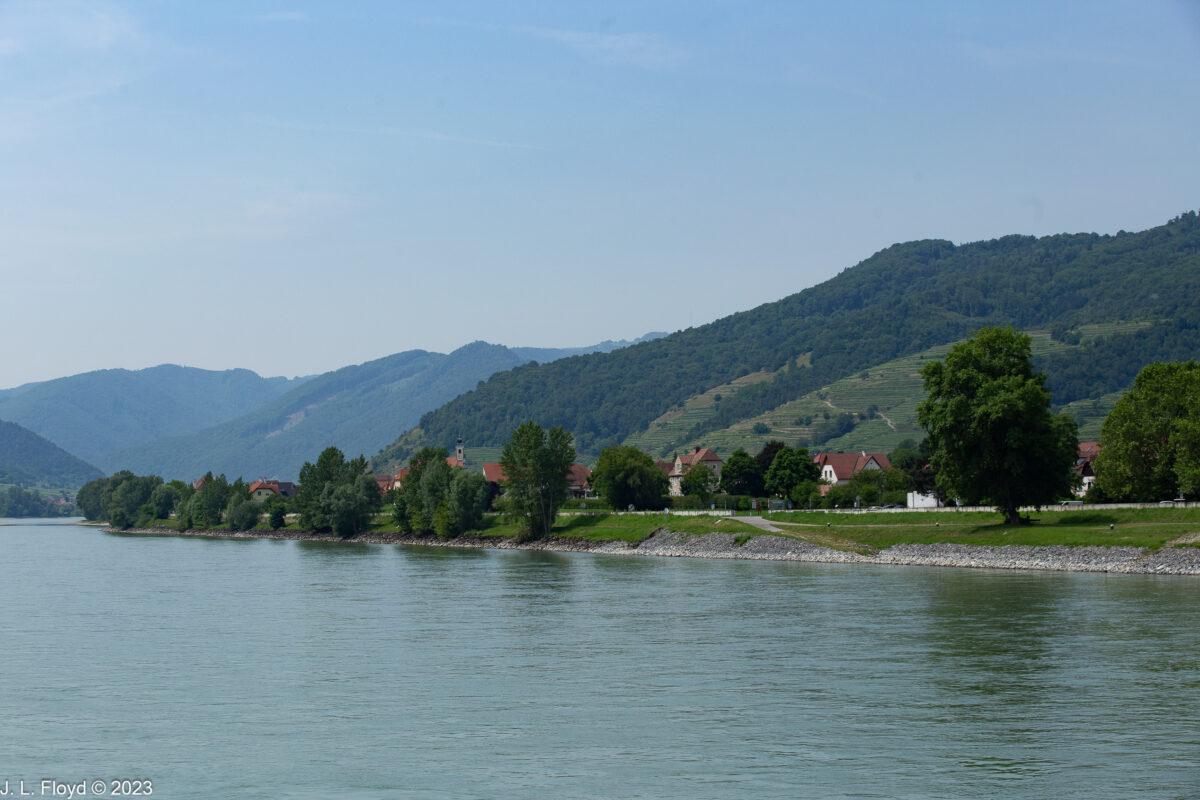
After passing Weissenkirchen’s neighbor, Wösendorf, we came to another village or hamlet, St. Michael’s, that was very different from its neighbors. Like Weissenkirchen, it had a wehrkirche (fortress church), but that church appeared to be carved out of the stone of the mountainside by giants and the rest of the village seemed to be no more than an insignificant adjunct to it. Indeed the village itself was nearly invisible, hidden in the trees, and the space between the mountainside and the Danube was so narrow that there didn’t seem to be any room for it. I found out later that there are only 13 houses in the village, but the church itself is very old and famous, dating from the tenth century in its original version. In its current incarnation it is Gothic, with a steep red roof and a square stubby tower with no spire on top. On its roof are said to be seven rabbits. I did not see them, and I can’t find them in my photos, but there is a legend associated with them: supposedly one winter’s night a blizzard filled the gap between the mountain and the church with snow, and the rabbits ran across the snow to investigate the church. But in the morning the snow melted, and the rabbits were stranded, with no way to get back to the mountain. Somebody – God, Mother Nature, whoever – felt sorry for them and turned them to stone so they could stay on the roof forever. Since I never saw the rabbits, I assumed that whoever turned them into stone later turned them back into live rabbits, and set them on the ground or gave them parachutes, so that they were then able to run away.


Turning my attention from the wehrkirche back to the river, I spied a couple of speedboats heading toward us. I thought they might be pirates coming to hijack us, but they sped on past, probably with bigger game in mind, such as pillaging Weissenkirchen. Meanwhile a couple of kayakers waved to us from their slender craft. In general we saw very few watercraft on the river in the Wachau Valley; I suspect that private boating is restricted to protect the pillars of the local economy – winemaking and tourism – by preserving the pristine ambience of the river. And to discourage piracy.


Just past St. Michael’s I noticed that the Wachaubahn railroad, which follows the Danube through the Wachau Valley, passes through a tunnel. The mouth of the tunnel is protected from rockslides by nets stretched over the mountainside above the railway. The nets also prevent rocks from falling on the Bundesstrasse highway, which runs below the railroad. For much of the way along the Danube from Dürnstein to Spitz, in the intervals between towns there is a narrow gap between the river and the towering stony cliffs, making for a rocky romance on this stretch of the Austrian Romantic Road. St. Michael’s just manages to fit in a small niche beside the road. Wherever there is any bare space on the mountainside that is not quite vertical, grapevines are planted.
There is a long history of viticulture in Austria, dating from pre-Roman times. But during the early medieval period after the fall of the Roman Empire, wine production in the area experienced a “dark age” owing to the ravages of invasions by barbarians such as the Huns, Vandals, Avars, Bulgars and Magyars. Eventually, with the pacification of the barbarians and the establishment of monasteries throughout Central Europe, agriculture and commerce began to recover. The monastic orders were particularly influential in promoting the spread of viticulture, identifying suitable sites along the banks of the Danube in the Wachau Valley and cultivating them. In the early modern period (16th-18th century) wine production in the Wachau, as well as Austria in general, made great strides, but during the second half of the 19th century the phylloxera epidemic decimated the wine industry in the Wachau as in the rest of Europe. In the twentieth century, the situation improved following the development of techniques of grafting European grapevines onto American root stock which is resistant to the depredations of the insect that causes phylloxera.
The Wachau Valley is noted for its white wines, which are produced mostly from two types of grapes, Riesling and Gr


A little further upriver from St. Michael’s, we encountered Spitz, a market town of about 1,600 people, a little larger than Ferndale, California (population 1,481) but with fewer churches (Ferndale had at least 13 when I lived there in 1965). Spitz has two main landmarks. One is the Tausendeimerberg. The other is the Hinterhaus castle, which I shall deal with later.
The Tausendeimerberg is a high hill in the middle of Spitz. The name means “Hill of a Thousand Buckets” because its vines produce a vast quantity of grape juice. As you will see from the pictures here, it is almost completely covered with grape vines.
Spitz is a hub of water transport, with a yacht marina, a Donaustation (terminal) for riverboats, and a cable ferry terminal, the third we encountered in the Wachau Valley. The marquee on the riverboat terminal building reads Ersten Donau Dampfschifffahrts Gesellschaft, “First Danube Steamboat Line Company.” Known by the abbreviation DDSG, it was founded in 1829 by a couple of mad Englishmen who convinced Metternich and the Emperor that the steam engine could replace draft animals as a means of propulsion for riverboats going upstream on the Danube. (They were right, of course, but it took a while for the venture to become viable.) The steam engines initially came from Britain since Austria was not yet industrially advanced enough to build them. After some initial setbacks, and a government takeover, the DDSG eventually (by 1880) became the largest inland shipping company in the world. But the First and Second World Wars brought disaster to the DDSG as to Austria in general, and in the aftermath the company was never fully restored to profitabilty. Additionally, after World War II passenger ship traffic along the Danube could not compete very well with railroad and automobile travel because of the long wait times in the Danube locks, which were the result of the construction of new power plants along the river. (We had to go through several of these waits before and after the Wachau Valley, but the schedule was calculated so that we mostly encountered the locks at night.) As a result, the company’s passenger service became mostly a tourist business. In 1991 the DDSG was divided into two units, with one, DDSG-Cargo GmbH, handling the cargo business and the other taking care of passenger service. The former is now owned by the Ukrainian company Ferrexpo. After no single buyer could be found for the passenger service, it was broken up and solod piecemeal to several outfits, the main one being DDSG Blue Danube Schiffahrt GmbH, which focuses on the core areas of Vienna and Wachau. Spitz is of course one of the riverboat stops for Blue Danube, as well as other lines. The DDSG Blue Danube operates two cruise ships that ply the Danube through the Wachau Valley. They put in at Spitz several times a day during the high season (April-October). Another line, the Brandner Schiffahrt GmbH, stops twice a day at Spitz.
The town of Spitz lies mostly between the base of the Tausendeimerberg and the riverbank. The Monarch Queen did not stop there, but from its top deck we got a good look at its elegant mansions, verdant vineyards and enticing eateries such as the Strandcaf
Spitz is a very old town. The area has been inhabited since Celtic times – 2000 BC or so. In 812 Charlemagne donated the land to a Bavarian monastery, Niederaltaich Abbey, and it remained a Bavarian enclave until 1504, when Holy Roman Emperor Maximilian I acquired it. But he sold it, and through various further transfers of ownership it passed into the grasp of Protestant counts and became a center of Reformation activity. During the Thirty Years’ War Spitz was devastated by both Catholic and Protestant troops, but eventually it wound up in the Catholic camp after its rulers, the Kuefstein family, reconverted to Catholicism.


High on a mountain spur to the southwest of Spitz stands the formidable-looking ruin of the Hinterhaus castle, the town’s second major claim to fame. It’s not certain when it was first built, perhaps in the 12th century, but it first appears in medieval chronicles in the year 1243. It was then owned by the Kuenrings of D
A little way upriver from the Hinterhaus, and beyond the boundary of Spitz, a spur of rock juts into the Danube. This is known as the Teufelmauer, or Devil’s Wall. According to legend, Satan wanted to build a wall or dam to flood the upper Wachau Valley, and God (for reasons unknown) gave him a single night for its construction with the proviso that if by the first cockcrow the wall was not finished it would collapse. Satan, perhaps realizing that roosters can crow at any hour and not just the break of dawn (and I know that from personal experience), bought up all the roosters from the nearby farms and slaughtered them to give himself a better chance of success. Tough luck for him – he overlooked one owned by an old woman from St Johann. Her rooster crowed and the wall collapsed. All that remains is the spur, which today is pierced by a tunnel.


After we passed the Teufelmauer, Sandie and I went below for lunch and watched the rest of the Wachau Valley go by from the ship’s windows. Thus I don’t have any photos of the towns of Schwallenbach, Willendorf, Groisbach, Aggsbach or the other towns of the Wachau Valley until we debarked at Melk. And our sojourn at Melk Abbey will be the subject of the next post.