Categories
Domestic Diversions

Cumbres & Toltec Scenic Railway, October 7, 2022

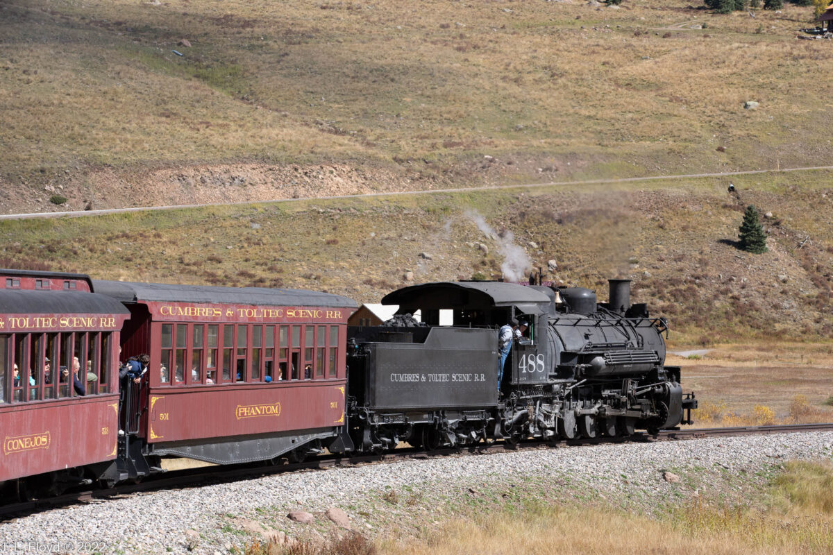
I enjoy riding on trains a lot. I much prefer trains to airplanes, because trains let me enjoy the scenery and I don’t have to stay glued to my seat. Road travel by automobile has its advantages, but one must focus on driving and navigating. Buses also have their merits, but they tend to be somewhat restrictive of personal movement and viewing. On a train you can get up and move to the other side of the train or down the aisle; on some trains you can go between the cars or go to other cars which afford a better view. This was true of the Cumbres & Toltec Scenic Railroad, which took us from Chama, New Mexico to Antonito, Colorado one fine Friday in October, 2022.

The Cumbres & Toltec Scenic Railroad, or C&TSRR for short, is one of the last remnants of a narrow-gauge network created by the Denver and Rio Grande Western Railroad to access the mineral resources of southwestern Colorado. It started in Alamosa, Colorado, and the section from Antonito to Chama was built in 1880. It was then extended from Chama to Durango and Silverton, Colorado, and the stretch from Durango to Silverton still exists as another tourist/heritage railroad. I won’t go through the history of the C&TSRR in detail; Wikipedia has an excellent article on that subject, to which I often refer. Here I’ll just mention that in its heyday the railroad not only transported gold and silver ores from Colorado but also lumber and agricultural products from the Chama area. By the 1960s these resources were depleted, and the Denver and Rio Grande found that its revenues no longer justified the costs of operating the railroad in wintertime, contending with the prolific snowfalls in the Cumbres Pass area, and the company abandoned the line in 1968. The section from Antonito to Chama was then reborn as the Cumbres and Toltec, which operates only in the summer season and carries passengers exclusively.

I heard about the Cumbres & Toltec from my sister JoAnne and her husband, Chuck, who used to be a railroad engineer. He is even more fond of trains, and very much more knowledgeable about them, than I. They live near Cleveland, Ohio, which is a long way from New Mexico; they planned to set out with their trailer and meet up with their friends Lou and Flo, from Cypress, California, in an RV park in Chama. When Sandie and I found out about their plans, we decided to crash the party, except that we don’t have an RV, so we reserved a room in the Elkhorn Lodge in Chama which turned out to be just down the street from their RV park.

We arrived at the Elkhorn on the afternoon of October 6, and joined the group in their RV park for dinner. The next morning we got up and had a very ample breakfast in the Elkhorn Lodge’s cafe, leaving plenty of time to drive the short distance into Chama to catch the train at 10 AM, or so we thought.

It turned out that I got my directions wrong and at 9:45, when my sister called on her cell phone wondering where we were, I was driving south, away from the train station, instead of north, toward the train station. I hung a fast U-turn and, breaking all speed records for that section of road and risking life and limb, arrived at the train station. The nearest parking space was a long way from the station, so we jumped out and let Chuck park the car while we jumped aboard the train in the nick of time. As we did so I realized I had left my camera in the car. Oh well, I thought, I’ll get by with my cell phone. But then it turned out that the conductor took pity on us and delayed the departure long enough for Chuck and me to go back to the car and retrieve the camera. That’s why I’m able to post nice full-frame Canon camera photos here instead of low-resolution cell phone shots.

Before continuing the tale, I need to make a disclaimer. Although the train had loudspeakers and an announcer gave a running account of the highlights of the trip, we couldn’t hear what was being said, so we never knew exactly where we were on much of the route, and in retrospect it’s very difficult in many cases to correlate points on the map with the pictures I took. So when I identify a particular photo as taken at, for example, Phantom Curve, be forewarned that I might be lying, and it could be Niagara Falls instead. But if you see anything that is flagrantly out of touch with what you think is reality, please let me know, and I’ll be happy to shower you with scorn and ridicule.

Even worse, be aware that just for fun I’ve included a number of purposefully outrageous lies, both in the text and the photo captions. I’m offering a prize of $100 to the first person who correctly identifies all the lies. (Hint: that’s the first lie.)

With that out of the way, let’s continue. The first leg of the trip, uphill to the Cumbres Pass, started out through the gently rolling wooded country of the Chama Valley. The aspen trees were starting to turn to yellow and gold with the onset of fall. Rolling through the aspen groves, we passed a ruined structure which I guessed was a stock pen for a former sheep ranch. There had once also been a water tank at the ranch, which was used in filming the movie Indiana Jones and the Last Crusade. We didn’t see the tank, though, since it was destroyed in a storm in 2006.

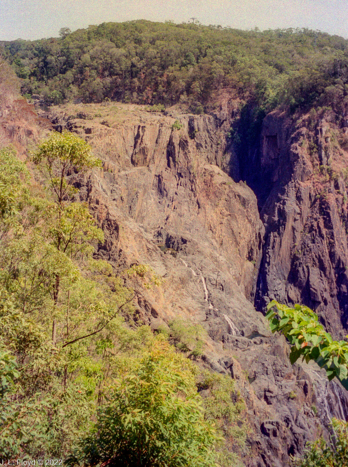
The rolling wooded country soon began to give way to stretches where the cliffs would tower over the train and deep gorges would yawn next to the rails, but the train kept chugging away on its gradual climb upward.

The train approximately followed the route of Highway 17, which like the railroad runs from Chama to Antonito. The highway crosses the railroad at several points, and cars have to stop to wait for the train to pass. 13.64 miles after leaving Chama, the train arrived at Cumbres Station, elevation 10,015 feet or 10,022 feet, depending on which sign you believe. It is the highest point on the railroad and the highest elevation of any narrow-gauge railroad in North America. (Don’t ask about standard-gauge railroads.) The long uphill climb from Chama uses up 3/4 of the locomotive’s water supply, so it must refill from a cistern at the station. The engineers also do a brake test, since the next stretch will be a long downhill.

Not long after leaving Cumbres Station, the train took a sharp turn to the south, parting ways with Highway 17 for a while and entering the storied Tanglefoot Curve where it doubles back on itself; this is done so that it can lose altitude gradually instead of risking burning out its brakes and careening wildly down a steep grade (which would happen if it followed the road) to end up as a pile of junk in Cumbres Creek. At Tanglefoot Curve the engine also performs a “boiler blowdown,” which entails releasing steam in a big puff to clear sediments at the bottom of the boiler.

After rejoining Highway 17 the train resumed its easterly direction for a while and then turned north into the Los Piños Valley, taking a long loop north to Los Piños Station. This is not a real station, though it probably was at some time in the past. Its sole claim to being useful is a water tank, but even this is only used for small engines and rotary trains (snow plows). But there are also a number of buildings in the area which make the place look like a station, so it’s easy to confuse with a real station and expect the train to stop there. Since I couldn’t hear the conductor’s announcements above the noise of the train, I did expect the train to stop there, thinking we had arrived at Osier Station, and was puzzled that it didn’t. Instead, it made a U-turn back to the south headed back to the point where it had turned north, and resumed its easterly course, leaving me to wonder why it had taken such a long, seemingly pointless detour. I speculate that most likely Los Piños was formerly important enough, maybe as a lumber pickup depot, to make it worthwhile for the train to stop there. Whatever the case, the Los Piños Valley is a pleasant alpine valley, with a wonderful pristine river, the Rio de los Piños, running through it. At least part of the riverfront belongs to the Western Rivers Conservancy, an organization devoted to preservation of habitat for fish and wildlife and to ensuring that rivers and streams remain available for public access.  

After completing the Los Piños Valley loop, the train turned eastward again, following the course of the Rio de los Piños, and crossed Cascade Creek, just north of where it flows into the river, over Cascade Trestle, the highest trestle on the line, running 137 feet above the creek.

From Cascade Creek it’s just a couple of miles to Osier Station, the mid-point of the journey. There we met another train coming up from Antonito, and we all stopped for lunch. After lunch we had time to stroll around and check out the station and its facilities before resuming the journey.

The Merriam-Webster Dictionary defines osier as “any of various willows (especially Salix viminalis) whose pliable twigs are used for furniture and basketry,” “a willow rod used in basketry,” or “any of several American dogwoods, especially red dogwoods.” We didn’t see baskets, willow rods or dogwoods of any color at Osier Station. Instead we saw a number of venerable structures including an old depot house, now a restroom, a water tank and a coaling facility; some old-time railroad equipment, such as the remains of a turntable; and some modern equipment, e.g. a little buggy that rolls along the tracks and pulls a trailer laden with maintenance tools – the modern-day equivalent of the old railroad handcar. My brother-in-law Chuck also regaled us with information about railroad tracks, where they are made and by whom, the different types, and so forth; for example, it turns out that curved tracks are made by a different company, to more exacting standards than straight ones, because they have to endure more stress and different force vectors. Incidentally, it’s also worth noting that the C&TSRR was built as a narrow-gauge railway (3 feet wide) not only because the narrow gauge was cheaper to build, but also because a narrow gauge railway can accommodate tighter-radius curves, allowing track to be laid where standard gauge (4 feet 8-1/2 inches) would not fit. 

After leaving Osier, the CTSRR train followed the course of the Rio de los Piños southeastward, crossing the state line back into New Mexico. Before long we arrived at the yawning chasm of Toltec Gorge, where the train crawls precariously along a narrow precipice while leaning shakily toward the dropoff, and we had to be careful not to make any sudden movements lest we rock the train and send it careening hundreds of feet to the bottom of the gorge six to eight hundred feet below us.

Near the confluence of Toltec Creek with the Rio de los Piños we passed through the famous Rock Tunnel, but I was unable to capture any photos of it since it was too dark inside and I didn’t bring my flash. The tunnel was blasted out of Pre-Cambrian igneous and metamorphic rock with black powder in 1880, and the rock is so hard that no shoring or lining was necessary. Unfortunately, several passengers who had climbed onto the roof of our carriage to see better were scraped off as we rode through the tunnel.

Somewhere near the mouth of Rock Tunnel, though I missed it at the time, there is a monument to President James A. Garfield, who was assassinated on that spot by Charles Guiteau, a madman and disappointed office-seeker, on July 2, 1981, shortly after emerging from the tunnel on one of the first trains to pass through it. (Actually, Guiteau shot Garfield with a British Bulldog revolver in the Baltimore and Potomac Railway Station in Washington, D. C., and Garfield lingered on for two months before dying, which probably could have been prevented by competent medical treatment. In those days insanity was given short shrift as a defense in a murder trial, and Guiteau was convicted and hanged in 1882.)

After exiting the Rock Tunnel, the train took a turn north and began a series of zigs and zags that took it back into Colorado, then south again. Somewhere in this bewildering sequence we rounded Phantom Curve, so named because of the eerie shadows that were created by the head light of the locomotive reflecting off the hoodoos along the tracks. Since it was daytime and the headlight wasn’t on, I didn’t see any eerie shadows, but I did see the hoodoos, which are ubiquitous along this part of the route.

Next we passed through another tunnel, 342 feet long and named Mud Tunnel because it was drilled through the soft weathered ash and mud of the Conejos Formation. Mud Tunnel is shored up with wooden pillars which occasionally collapse, burying whatever train is passing through and making it necessary to construct a temporary bypass called a “shoo-fly” for subsequent trains. The way this works is that the train is stopped and passengers and cargo are moved via the bypass to another train waiting on the other side of the tunnel. Fortunately, we did not have to endure this somewhat inconvenient arrangement.

After emerging safely from Mud Tunnel, the train arrived at Sublette, an abandoned railroad section camp, high in the southeastern San Juan mountains at 9,281 feet. The section house, bunk house and other structures have been restored and are maintained by the Friends of the Cumbres & Toltec. Sublette still functions as the first water stop for trains coming up from Antonito.

Leaving Sublette, the train began a gradual descent down from the mountains toward the plains west of Antonito and briefly crossed into Colorado again, where it traversed a pretzel-shaped stretch of track known as Whiplash Curve, a prime example of how early railroad builders used curves to gain elevation while keeping the grade as flat as possible.

Not far from Whiplash Curve, after crossing the state line again, we passed the siding and wye of Big Horn, New Mexico. The siding is no longer connected to the main line. A wye is a piece of track constructed, as one might guess, in the shape of a letter “Y”; its purpose is to enable a train to turn around by backing up on one leg of the wye, then pulling forward on the opposite leg to go in the other direction. This wye was originally constructed to enable snowplow trains to turn around, but it is now rarely used; since the Scenic Railway does not operate during the winter months, the rotary snowplow trains (of which there is only one left) are run only on special occasions.

By this time we were down on the plain of San Luis Valley, an incredibly flat, dry and boring expanse, but there was still one point of interest left on the route, though I missed it because I fell asleep. This was the chasm spanned by Ferguson’s Trestle, named for a man who was hanged from a locomotive there. Why they would hang him from a locomotive, when they had a trestle ready at hand for that purpose, I never found out.

At least the last part of the ride went by quickly, since the train had a straight and level shot to Antonito, and we pulled into the terminal sometime around 4:30 PM. Annoyingly, we had little time to check out the train terminal there because we shortly had to board our buses for the trip back to Chama shortly afterward.

Since it was October, darkness came early and we didn’t have long to enjoy the scenery on the way back. Also we were all tired and mostly fell asleep, until we were rudely awakened by an onslaught of nature. As we neared Chama, the skies, which had been sunny and bright all day with only a few puffy cumulus clouds, almost instantaneously clouded up and then began to shower bolts of lightning, claps of thunder, and a deluge of rain on our bus. We had to abandon plans for an outdoor barbecue upon our return and shelter in the Outlaw BBQ Company in downtown Chama. This was appropriate for me, an outlaw and carnivore by nature, but not so much for Sandie, who as a mostly-vegetarian had trouble finding something acceptable, since the menu had no non-meat entrees. She had to make do with side dishes such as potato salad. (Recommendation for Outlaw BBQ: Your barbecue is wonderful, but please include some vegetarian entrees on your menu.) Other than that, it was a pleasantly sybaritic end to a glorious day.

I highly recommend the Cumbres and Toltec Scenic Railroad as a day trip in the northern New Mexico/southern Colorado area.

Categories
Australia, November-December 2002

Adelaide, December 5-7, 2002

After the climactic experience of the total solar eclipse we had a few more days to continue our enjoyment of Australia in the elysian city of Adelaide and its environs.

I have seen few places on earth that approach the city of Adelaide in livability. Getting around was easy and everyplace we went in and around the city was primo.

Our hotel, the Stamford Plaza on North Terrace, was five-star and close to several attractions that we were quick to enjoy. One was the South Australian Museum, almost across the street from our hotel, where we toured exhibits on the natural history of Australia and what is claimed to be the largest and most comprehensive collection of Australian aboriginal cultural material in the world. Our souvenirs of that experience include paintings by aboriginal artists which still hang on the walls of our house. Another was the Rundle Street Mall, where we visited the store of the Australian Geographic Society – Australia’s counterpart to the National Geographic Society of the USA – and I bought my first Aussie leather hat.

Although the Stamford Plaza was a perfectly fine hotel, we didn’t stay there long. After the first night back, the organizer of the Arkaroola trip, Rob Hill, invited us to stay with him and his wife Janita in their lovely home in Aldgate, an upscale suburb just east of Adelaide. (By then Chuck and Elouise Mattox had departed for Sydney and points beyond; in contrast to us, they did their extra-eclipse Australian tour post-eclipse, instead of pre-eclipse.) Rob showed us around his neighborhood, where there were a number of beautiful homes, including an estate owned by Mel Gibson, the actor. Unfortunately no one was home at the time, so we only got to see it from outside the property.

Note: I’ve also included a photo of Rajah Hashish Yi-Jen Guy-Jean Pierre, my Abyssinian cat, in the following gallery. He didn’t accompany us on the trip to Australia – he wouldn’t have enjoyed the plane rides – but he wasn’t forgotten, and he was of course happy to see us upon our return. He came to me in 1992 from Al and Judy Potthoff, whom he left on account of feeling crowded by their new son Paul, and stayed with me through my move to Long Beach in 2002, until he passed away in 2004. He was a highly intelligent, affectionate and gracious being (not to mention haughty, incredibly stubborn and majestically aloof), true royalty, and I greatly treasure his memory.

Rob was also kind enough to chauffer us around to visit some of the premier sights in the city and its environs.

Among other sights, Rob showed us a monument to Colonel William Light, the first Surveyor-General of South Australia, and also the founder and designer of the city of Adelaide. His plan called for the city center to be arranged in a grid of five squares, surrounded by parklands. His vision was controversial at first but eventually proved to be sound, ensuring that the city would have wide multi-lane roads, an easily navigable grid layout and extensive green areas.

Thanks to Rob, we also visited a monument to Matthew Flinders, who circumnavigated Australia and explored the South Australian coast, and became better acquainted with his somewhat tragic history. He began his naval career as a midshipman in the 1790s, and his early experiences included service under Captain William Bligh, though not on the voyage noted for the celebrated mutiny on the Bounty. He went on to serve on a series of voyages of exploration to Australia, as a result of which he was given command of a 334-ton sloop, the HMS Investigator, with the mission of charting the coast of Australia, then known as New Holland – Flinders was among the first to call it Australia. Sailing from England in July 1801, Flinders made for the southern coast of Australia, and explored it extensively, including the area where the city of Adelaide was later to be situated. He also gave the large island at the mouth of St. Vincent Gulf south of Adelaide its present name of Kangaroo Island.

On a subsequent expedition, lasting from July 1802 to June 1803, Flinders accomplished the first inshore circumnavigation of Australia. But on the completion of that voyage his ship Investigator was found to be rotten and unfit for further service. He sailed for England on another ship, which was wrecked on the Great Barrier Reef, a fate which befell many ships in that era. He then took command of still another ship, the schooner Cumberland, and set sail for England, but that ship was in such poor shape that he had to put in for repairs in December 1803 at the island of Mauritius in the Indian Ocean. Unfortunately that island was a possession of France, with whom the British were then at war, and the French governor took Flinders and his ship captive, despite his protests that he was on a purely scientific expedition and had a passport exempting the Investigator (but not the Cumberland) from hostilities. He was not freed until 1810, when a British fleet blockaded Mauritius.

Before leaving for Australia in 1801, Flinders had married his longtime sweetheart, Ann Chappelle, intending to take her with him to Australia, in defiance of British Admiralty rules forbidding wives of captains accompanying their husbands on voyages, but his plan was discovered and he was forced to leave her behind. Thus he had not seen her for nine years when he returned to England. They did not have long to enjoy their reunion, because Flinders’ health had suffered during his captivity on Mauritius, and he died of kidney disease in 1814 at age 40. However, he had managed to father a daughter, Anne, in 1812; she later married a man named William Petrie, and the couple became the parents of Sir William Matthew Flinders Petrie, a famed archaeologist and Egyptologist noted for his discovery of the Merneptah Stele and the proto-Sinaitic script which was the ancestor of most alphabetic scripts.

Rob Hill also took us to the highest point in the Adelaide area, Mount Lofty, which at 710 meters or 2330 feet is not exactly Mount Everest, but provides great views of Adelaide and the surrounding area. It’s also a favorite destination of hikers and mountain bikers, although we were able to ride up in Rob’s car.

From Mount Lofty we descended to the Barossa Valley, 60 km (37 miles) east of Adelaide, one of Australia’s premier wine-producing regions, famous for its Shiraz vintages, of which I am inordinately fond. Shiraz is of course the name of a major city in Iran, which used to be famous for its production of the wine, but under the current repressive regime wine is outlawed there. However, the grapes to produce Shiraz were imported not from Iran but from the Rhone Valley in France, where the wine is known as Syrah, and that is its name in most places, but the Aussies like to call it Shiraz, and that’s fine with me. It’s good under any name.

The Barossa Valley was settled largely by German immigrants in the 1840s, and the German influence is still apparent there. The town of Hahndorf, not far away in the Adelaide Hills, was founded by German immigrants even earlier, in 1838, making it Australia’s oldest German settlement. They came from a village in Prussia which was transferred to Poland after World War II, as part of the relocation of the western Polish border to the Oder-Neisse line. German heritage is reflected in the architecture of Hahndorf. Its pleasant appearance and welcoming atmosphere make it a major tourist attraction in the area, and we thoroughly enjoyed our brief time there.

Rob Hill also took us to the beaches near Adelaide, which were pristine but a trifle chilly; you could feel the breeze blowing up from the South Pole there. Unfortunately none of my pictures from that locale have survived; by an oversight I shot them on the same film that I used to take some of the pictures in Port Douglas, and all of them were thus rendered unsalvageable. The same happened to the pictures I took of our outing with members of the South Australian Astronomical Society. That happened on our last night in Australia, before we flew back to the US on December 7. It began before sundown and extended into the late hours of the evening, with members setting up their scopes in a park and showing us views of the amazing sights of the austral sky, which put to shame those of the north. The SAAS people were a splendid lot and I wished we could spend lots more time with them, but the evening we did have was great fun and a fitting sendoff for our stay in the land of Oz.

Categories
Australia, November-December 2002

Total Solar Eclipse, December 4, 2002

On December 4, 2002 our tour group piled into two buses and set out for the eclipse viewing site, which was in the Outback, a six-hour bus ride from Arkaroola. The site was near Mt. Hopeless, which was appropriately named because there was obviously no hope of ever getting back to civilization, or even surviving, if you were stranded out there without motor transport. Quite simply, it was in the middle of nowhere.

It’s often said that getting there is half the fun. This is true, if you define “getting there” as traversing mile after mile of desolate, featureless landscape, then stopping halfway for lunch and finding out that one of the buses has a hole in the radiator and all its coolant has leaked out, so that it can neither go on nor go back, because there is no water the rest of the way, and you can’t risk having the other bus break down and leave everyone stranded in the middle of nowhere, so it looks like everyone will have to pile onto one bus, where the passengers will take turns standing up and sitting down while it wends its way back to Arkaroola, hoping that it doesn’t break down too.

Fortunately, that didn’t happen. We had a few bad moments while Rob Hill and the bus drivers discussed the situation. But they had a backup plan, and soon a Toyota truck showed up with a large tank of water in the bed. It followed us the rest of the way to the viewing site and back to Arkaroola, and whenever the bus radiator ran short of water, we stopped while it was refilled from the truck. I don’t know where the water truck came from nor whether this had been long planned for beforehand, but I have to hand it to Rob Hill and the bus operators for covering this contingency, because it saved the trip.

Finally we arrived at the viewing site. It was the most godforsaken place I’ve ever seen. It was completely flat for miles around. The landscape was absolutely featureless. There was nothing there – no gas station, no souvenir shop, no hot-dog stand, no toilets, no trees, not even a billboard or a beer can – nothing. It was absolutely perfect for our purposes, except maybe for one issue: the wind. I set up my camera on a tripod and the wind blew it over. But it was undamaged, and after righting the tripod I photographed the eclipse without further hindrance, except from my own ineptitude.

I had been advised not to try to photograph my first eclipse, because you risk becoming so involved in operating your equipment that you miss seeing the eclipse. I completely disregarded that advice. I had an Olympus OM-1 film camera and used a 70mm TeleVue Pronto scope for a lens, with a mylar filter over the aperture. I had the setup mounted on a TeleVue Telepod, which is just a plain tripod, suitable for holding a TeleVue scope but not equipped with any tracking or guiding capability. I had Ektachrome 200 and 400 color film, and some Fujifilm – I don’t remember what I actually wound up using.

Although completely inexperienced as a solar eclipse photographer, and hardly an expert at photography in general, I managed to capture a respectable sequence of images. I was a little slow in finding the right combination of optics. The solar image didn’t fill the scope’s field of view as much as I would prefer, so I tried using eyepiece projection to magnify it, but that made it too large, so after a couple of shots I switched back to the unmagnified setup. I also fumbled around for a while trying to nail down the appropriate exposure settings, and missed shooting first contact (the second when the Moon’s shadow first reaches the Sun’s disk) as a result.

We were seeing the eclipse almost at the very end of its path across the Earth. It began over the South Atlantic, continued over Africa and the Indian Ocean, and finished up in Australia, a bit to the northeast of our site. The maximum duration of totality was 2 minutes, 4 seconds, but that was in the middle of the Indian Ocean. At our viewing site totality occurred about 7:45 PM and lasted about 30 seconds. The partial phase began about 6:40 PM. Shortly after the end of totality, the sun set, still partially eclipsed.

Photographing totality is tricky. Until it arrives, you have to keep the filter on your scope; if you look at the unfiltered sun, even when partially eclipsed, you will blind yourself and destroy your equipment. But when totality arrives, it instantly becomes dark, and you have to jettison the filter quickly – otherwise you’ll get no picture at all. You also have to speedily readjust your camera settings to compensate for the change in light levels. Especially with as short a duration of totality as we had in 2002, if you fumbled around trying to find the right settings for long you would miss totality entirely! Fortunately I managed to avoid this pitfall and captured some decent images of the totally eclipsed sun.

Normally the post-totality phase of a solar eclipse is something of an anticlimax, and many people ignore it altogether, packing up and going home right after the Sun begins to emerge from the Moon’s shadow. That wasn’t the case for the 2002 eclipse in Australia. The sight of the partially eclipsed setting on the horizon was spectacular and kept people mesmerized until the last tip of the crescent disappeared off the edge of the world.

The organizers had planned carefully, and they had brought along equipment to provide a superb barbecue using organic beef contributed by local ranchers. Once dinner was over, we climbed into the buses and began the six-hour drive back to Arkaroola, which most of us spent in an unconscious state. Arriving back at our lodgings in the middle of the night, we were able to get just a few hours more sleep before we had to rise and pack for an early-morning departure for Adelaide.

Categories
Australia, November-December 2002

Arkaroola, December 3, 2002

On Day 3 of our stay in Arkaroola we were scheduled for the Ridgetop Tour, an outing that would take us into the wildest parts of the Flinders Range in 4-wheel drive vehicles. Before embarking on that excursion, though, Chuck and Elouise, feeling the need for more physical activity than riding around in trucks would provide, decided to do a morning bushwalk in the immediate vicinity of the resort, and I joined them.

The Ridgetop Tour is justly considered one of the premier experiences offered at Arkaroola Resort. It lasts about four and a half hours and goes through the most picturesque and rugged parts of the Flinders Range, taking the visitor to dizzying precipice lookouts and awe-inspiring gorges.

The Ridgetop Tour culminates in a climb to the top of Sillers Lookout, a vertiginous promontory near the northern end of the Flinders Range; it provides some stunning views of the different kinds of terrain encountered in this part of the world.

Since all of the next day, December 4, would be devoted to seeing the eclipse, December 3 was in effect our last full day at Arkaroola, so as a valedictory I’m going to present some of the scenes we encountered during our stay that I haven’t already posted.

Of particular interest to me was the telescope setup I encountered outside one of the lodges. It sat out there the entire time we were at Arkaroola, but I never saw anyone using it, and I never found out who owned it or made it. It was not a commercial setup; except for the telescope itself, it was obviously all homemade, by somebody who must have known what they were doing. They had cobbled together an equatorial mount, which consisted of a box presumably containing a motor and gears which would run the clock drive that turned the scope to follow the motion of the stars across the sky. The box was mounted at an angle suitable to match the latitude, so that the scope could be polar aligned. The scope was a Takahashi, I don’t know what model, but it was somewhere in the 100-110 mm range. Takahashis are among the highest quality refractors made, and they are quite expensive; this one would have cost upwards of $4,000 USD.

Categories
Australia, November-December 2002

Arkaroola, December 1-2, 2002

We flew from Cairns to Adelaide on November 30 and met up with Chuck and Elouise Mattox at our hotel. They knew a couple in Adelaide, the Fosters, and we were able to spend a most pleasant time at their house in Adelaide that evening. We boarded our bus for Arkaroola the following morning, December 1, 2002.

A couple of hours after leaving, we stopped for lunch in Burra, about 180 kilometers (112 miles) from Adelaide. Burra began in the mid-19th century as a mining town; when the mines gave out it kept going as an agricultural market town, but eventually developed a new identity as tourist center as well, a kind of gateway to the Outback. We found it a charming place. Sandie said it had the ambience of a Midwest American small town fifty years ago; I would have said pre-World-War II as well. Lads on bicycles greeted us with “G’day, mate” as we strolled the main street.

As we continued on from Burra, we began to encounter the real Australian Outback, and signs of civilization became few and far between. The land became barren and desolate, reminiscent of the Mojave Desert of California. Only the occasional kangaroo popped up to remind us that we were really in Australia.

After many uneventful hours we finally arrived at our destination, which rose up as a welcoming oasis in the endless wasteland. We settled into comfortable quarters – ours were in Greenwood Lodge, one of several hostels at the resort and conveniently close to the office, bar and lounge.

It turned out that Arkaroola had a couple of observatories, each equipped with an 11-inch Celestron Schmidt-Cassegrain telescope, the same model as the one I had at the time (I still own it, actually). Douglas Sprigg, the proprietor of Arkaroola, took us up to one of the observatories and showed us the wonders of the southern sky. It was the first time that I had seen with my own eyes the Magellanic Clouds, the Jewel Box, Alpha Centauri, Eta Carinae and other fabled objects that lurk too far south to see from Southern California.

We had a couple of days to pass in Arkaroola before the eclipse on December 4, and a number of interesting activities had been scheduled to keep us busy during that period. The first was a bushwalk conducted by aborigine guides, who acquainted us with the local flora and fauna, and provided instruction in the ways of the tribes, their techniques of obtaining sustenance and otherwise coping with the exigencies of life in the Outback.

Evenings were occupied with parties in the lounge, featuring aboriginal song and dance, and also instructional sessions provided by Victor and Olga Gostin. Olga, professor of anthropology at the University of South Australia, acquainted us with the history and culture of the Australian aborigines in general and the local tribes in particular. Victor, a geologist, held forth on the geology of the area, in particular the Lake Acraman impact crater, the second-largest in the world, of which he was co-discoverer. The fact that both Victor and Olga both come from Russian emigre family backgrounds gave me a special interest in becoming acquainted with them and greatly enhanced the Arkaroola experience.

I can’t omit mention of the cuisine at Arkaroola. It was all superb, but the barbecue dinners were especially memorable. I should mention I love barbecue and do it all year round at home, since the Southern California climate is amenable to outdoor cooking. I would guess that the same is true in South Australia. In any case, it was summer, the days were long and warm, and barbecues were de rigeur as well as most welcome. Naturally one would expect a livestock-abundant country like Australia to have beef, lamb and pork aplenty, and this was indeed the case; but we also had the opportunity to try new and exotic (to us) meats such as camel, emu, kangaroo and koala.

By the way, I’m just kidding about the koala. Even if one were so unfeeling as to barbecue a koala, it would be illegal; they are a protected species.

Categories
Australia, November-December 2002

Port Douglas and the Great Barrier Reef – November 29, 2002

Unfortunately, I don’t have much to show for the day we spent on the Great Barrier Reef. I didn’t want to take my Olympus film camera on the boat to the Reef, so I bought a waterproof throwaway camera in Port Douglas which was able to take pictures underwater. I used that camera to take pictures in Port Douglas as well. This worked fine at the time, but years later, when I went back to scan the pictures, I discovered that the film had deteriorated to the point where most of them were illegible.

Categories
Australia, November-December 2002

Kuranda, November 28, 2002

From Sydney we flew up north to Cairns in Queensland and then took a bus to our hotel in Port Douglas, an hour east of Cairns. The next day we came back to Cairns to catch a train on the Kuranda Scenic Railway.

It was at this point that I discovered that my brand-new Nikon E5700 digital camera was no longer working. To get it fixed I would have to ship it to the Nikon service center in Torrance, California, and that obviously had to wait until I got home. Fortunately I had a backup – my trusty Olympus OM-1 film camera. So I pressed it into service for the rest of the trip. Unfortunately, some of the film that I used on the Kuranda trip and subsequent peregrinations in Australia seems to have deteriorated over time, and maybe wasn’t the best to begin with, so the photos on this page are not up to the quality of those taken in Sydney; they range from rather grainy to wretchedly murky or blurry.

As soon as the train leaves the station in Cairns, it starts to climb up into the hills, approximately following the course of the Barron River for most of the way. It enters a dense rain forest, which crowds closely along the railroad tracks. The railroad was originally built in 1891 and runs 37 kilometers, or 25 miles, through the jungle and the mountains until it reaches Kuranda on the Atherton Plateau. Many tunnels and bridges had to be built to accommodate the railroad, and the construction is said to have cost many lives. The route is subject to rock falls and in 2010 had to be closed for repairs for several months after 5 passengers were injured when the train was derailed by a landslide.

The train passes through the spectacular gorge of the Barron River, and as it nears Kuranda it stops at a lookout, with a sweeping view of Barron Falls. There we were able to disembark for a few minutes and take pictures of the gorge and falls unobstructed by the train windows. The flow of water over Barron Falls is somewhat restricted by a dam, which also provides hydroelectric power to the area, so that for most of the year it is a mere trickle and only reaches full volume after a heavy rain during the wet season; we were there during the dry season. It was a spectacular view nonetheless.

After a two-hour ride, we arrived at the village of Kuranda, where we explored the shops, enjoyed the slightly quaint, thoroughly pleasant late 19th/early 20th-century ambience, ate lunch and bought a few souvenirs. I got a boomerang and a didgeridoo, and a sturdy long-sleeved shirt to protect my skin from the fierce Queensland sun.

After sampling the delights of Kuranda, we headed back to Cairns. We did so on a different mode of transport from the one we had taken to get there: the Skyrail aerial tram. This took us above the impenetrable jungle and gave us some more spectacular views of Barron Gorge, the falls and the river, and also made a couple of stops where we could get off and descend into the rain forest to view the magnificent trees and abundant foliage.

The Skyrail runs above the Queensland Wet Tropical Forest, the world’s oldest tropical rainforest, even older than the Amazon. There are unsubstantiated rumors that dinosaurs still roam its unexplored depths. The Skyrail was completed in 1995, and it was the world’s longest gondola cableway at the time. Helicopters had to be used to construct the cable towers, because there were no roads in the rain forest, and all efforts to build roads there failed because the construction crews were eaten by T. rexes.

Categories
Australia, November-December 2002

Featherdale, November 26, 2002

On the way back from the Blue Mountains our bus took us to the Featherdale Wildlife Park in the parklands just west of Sydney. Featherdale featured a wide variety of native Australian creatures, birds as well as terrestrial animals, and of course kangaroos were well represented among them.

Like everyone else, we were captivated by the koalas, who seem to have an irresistible appeal. Also, unlike kangaroos, they are approachable; they don’t seem to mind being petted and admired, despite what the Qantas ads would have you believe.

But I think it was the birds at Featherdale that most surprised and delighted me. Australia is a bird-watcher’s paradise; their variety, colorfulness and weirdness exceeded anything I ever could imagine. And Featherdale seemed to have them all – parrots, cockatoos, swans, kookaburras, emus, penguins, herons, you name it. The onliest problem was that many of them were in cages (or locations within the cages) that were not camera-friendly, so the photos here represent only a limited selection of what we actually saw.

I have seen sulfur-crested cockatoos in the USA, where they are bred for sale as pets, but in Australia they are common in the wild. They are all white except for their yellow crest; they are extremely curious and intelligent birds and are known for being able to learn to talk and to open garbage cans in Sydney to raid them for food. But that’s just the beginning for them; they have been rapidly begun to master new tricks, such as raiding gardens and farms for produce, hijacking mobile food trucks, using microwave ovens to cook their food, etc. In fact, the one in Featherdale told me that they were making plans to reverse the extinction of the dinosaurs 65 million years ago and take back the world from humans and other mammals. (Birds are known to be descended from theropod dinosaurs.)

Black swans are also common in southeast and southwest Australia, and we had already seen a few, e.g. at Disneyland in Anaheim. But I have never seen one in flight; they are said to have white flight feathers, which should make them a spectacular sight on the wing. The pair in Featherdale had cygnets – baby swans – with them.

The Eastern Great Egret was a beautiful sight: all white except for its black bill and green face mask. I later found out that ordinarily it is entirely white with a yellow beak, and the colors we saw appear only in breeding season.

We also saw some cute little penguins, and it turned out that it’s not only a description but also the species name. There are two species of these, one native to Australia, and the other to New Zealand. (The Australian variety has also invaded New Zealand.) The Little Penguins in Australia live on the southern coasts and offshore islands.

We had been introduced to the Australian White Ibis in Hyde Park in Sydney, so we were not surprised to see them in Featherdale. They are widespread over much of Australia, but it turns out that they have only invaded urban areas of Australia since the 1970s. It seems they have developed a taste for human food scraps, which they enjoy in addition to their natural diet of various invertebrates – they especially favor clams and mussels, which they dig out with their long bills. I don’t doubt that they have now joined forces with the cockatoos in their scheme to displace humans.

There was no end to the delightful and sometimes bizarre avians at Featherdale. We came across an emu who was investigating a middle-aged gentleman seated on a railing; he claimed to be conducting a scientific study of humans. Next we encountered a laughing kookaburra, another iconic Australian bird, who thought we were hilarious. But in the same pen with the kookaburras was the most bizarre and ridiculous bird I have ever seen, which was billed as a Tawny Frogmouth. It somewhat resembled an owl, and we thought at first that it was an owl, but we were informed that it is related not to owls but to swifts and hummingbirds, which I find quite difficult to believe. Like the owl, the frogmouth is a nocturnal feeder, but unlike the owl it is a weak flyer, so it depends primarily on camouflage for success as a hunter, as well as its broad flat hooked bill, which it uses to capture insects; frogmouths also like small vertebrates such as mice and frogs.

Getting back to the mammals, Sandie found a cute little marsupial in one of the open gardens – I’m not sure whether it was a baby kangaroo or a wallaby – and quickly made friends with it.

Next we came across a den with – or so it appeared at first – nobody home. But then in the darkness we could make out the hindquarters of a creature that turned out to be a sleeping Tasmanian devil. I had never seen one of these outside of a Looney Tunes cartoon, so I really wanted to know what they look like; but try as I might, I couldn’t coax the creature to come out of its den, or even wake it up. I had to look up the species on Wikipedia to find out what it looks like. Turns out it looks (and behaves) somewhat like a cross between a dog and a wolverine. According to Wikipedia, “It is characterised by its stocky and muscular build, black fur, pungent odour, extremely loud and disturbing screech, keen sense of smell, and ferocity when feeding.” It is carnivorous, both a hunter and a scavenger, and has the strongest bite for its body mass of any extant land animal.

A couple of rather large bats hanging upside-down in their cage caught my attention. I expected to find out that they were vampires, but it turns out that they eat pollen, nectar and fruit, and moreover are key pollinators. The grey-headed flying fox, as the species is known, is the largest bat in Australia and lives mainly in the southern and eastern regions of the continent. It does not echolocate but rather relies on sight and smell to find its food; the expression “blind as a bat” does not apply in this case.

And finally there were the serpents. I find snakes to be both fascinating and repellent. Australia is known for its venomous snakes, of which there are many varieties, most of them quite deadly. The inland taipan snake is supposed to have the most toxic venom in the world. However, we were informed that once bitten by an Australian snake, if you can get the antitoxin in time, you will recover more quickly and completely than if you were bitten by a cobra or a rattlesnake, whose venom supposedly has more long-lasting complications. I resolved not to test this assertion. The Australian snake with the second most toxic venom in the world is the Eastern Brown, a fast and agile snake which is responsible for about 60% of human snake-bite deaths in Australia. At Featherdale we saw tiger snakes, eastern browns and Australian copperheads; I’m not sure exactly which ones appear in the following photographs.

I can’t finish this post without bringing up the 1962 Rolf Harris song “Tie Me Kangaroo Down, Sport”:

There’s an old Australian stockman lying, dying
And he gets himself up onto one elbow and he turns to his mates
Who are all gathered around and he says

Watch me wallabies feed, mate
Watch me wallabies feed
They’re a dangerous breed, mate
So watch me wallabies feed
Altogether now!

Chorus (repeats after each verse):

Tie me kangaroo down, sport
Tie me kangaroo down
Tie me kangaroo down, sport
Tie me kangaroo down

Keep me cockatoo cool, Curl
Keep me cockatoo cool
Ah, don’t go acting the fool, Curl
Just keep me cockatoo cool
Altogether now!

Take me koala back, Jack
Take me koala back
He lives somewhere out on the track, Mac
So take me koala back
Altogether now!

And mind me platypus duck, Bill
Mind me platypus duck
Ah, don’t let ‘im go running amok, Bill
Just mind me platypus duck
Altogether now!

Let me Emus go loose, Bruce
Let me Emus go loose
They’re of no further use, Bruce
Let me Emus go loose
Altogether now!

Play your didgeridoo, Blue
Play your didgeridoo
Keep playin’ ’til I shoot through, Blue
Play your didgeridoo
Altogether now!

Tan me hide when I’m dead, Fred
Tan me hide when I’m dead
So we tanned his hide when he died, Clyde
And that’s it hangin’ on the shed!
Altogether now!

OK, I have to admit that I put in my own version of one of those verses. Originally it was “Let me Abos go loose, Bruce,” and that was the way I first heard the song on the jukebox when I was working in the Blue Door Cafe in Long Beach in 1963, but that verse was later deleted because the reference to “Abos” – aborigines – was considered racist. I don’t understand why they didn’t just replace “Abos” by “emus,” which has the same number of syllables and is an Australian animal, so I did it myself. So far, the emus haven’t objected to that.

Categories
Australia, November-December 2002

Blue Mountains, November 26, 2002

On Day 4 in Sydney our tour bus headed up the Great Western Highway to the the Blue Mountains. Our destination was a town called Katoomba. As we climbed up into the hills we got some nice views of the coastal plains west of Sydney from the bus.

Our first stop in the Blue Mountains was the village of Leura, which provided a pleasant introduction to the area.

From Leura it was just a short ride to Scenic World in Katoomba, where we hopped aboard a Scenic Cableway gondola for a ride to the floor of Jamison Valley.

On the floor of the Jamison Valley we found a lush, dense temperate rain forest, which we could observe from a walkway constructed above the ground so as to preserve the forest floor from damage by thousands of human feet tramping over it, and saving the humans themselves from having to stumble over rocks and tree roots or blunder into hanging vines.

From the valley floor we also had stunning views of the geological features of the area, including the towering cliffs of Katoomba with their spectacular rock formations.

After completing our stroll along the Scenic Walkway, we jumped on the Scenic Railway for the ride back up to the clifftops. It was a pretty exciting ride. The Katoomba Scenic Railway claims to be the steepest funicular railway in the world and I don’t find that hard to believe. It was better than an amusement park roller coaster.

The Scenic Railway ride ended our stay in Katoomba, but our tour day wasn’t over yet. We still had the Featherdale Wildlife Refuge west of Sydney to visit. But on the way there, we had to witness a spectacle that was all too familiar to Aussies, and would become even more so in subsequent years: a bush fire.

Categories
Australia, November-December 2002

Sydney Harbor Cruise, November 25, 2002

On the afternoon of our day in Sydney we went on a harbor cruise. We boarded the cruise boat at Circular Quay, in The Rocks district right next to Sidney Harbor Bridge.

Sydney Harbor cruise boats come in many shapes and sizes, but most of them are catamarans like the ones shown below.

As we pulled away from the dock we got a great view of the Sydney Opera House. Photos of the Opera House are a dime a dozen – it’s probably the most photographed landmark in Sydney – so it didn’t make sense for me to take a bunch of pictures of it, but I did anyway, and here they are – I’ll just put all of them out here at once.

As you might expect, we saw a profusion of pleasure boats of all kinds in Sydney Harbor, both wind- and motor-powered. Having crewed on a few sailboats in my younger days, I was mostly interested in the wind-powered kind, and I shot a plethora of pictures of them, ranging from centerboard dinghies to luxury yachts.

One sleek sloop moored off Darling Point got my attention because it bore the letters “UCLA” on the sail cover. I wondered whether the boat belonged to UCLA, or the owner was a UCLA alum, or whether “UCLA” in this case stood for something other than “University of California at Los Angeles”, such as “United Calvinist Laymen of Australia” or “Undersea Congress of Lustful Anchorites.”

Sydney is one of the world’s ten or fifteen most expensive cities to live in, and the shores of Sydney Bay, lined with opulent residences, have some of the most pricey real estate in the world. Of course, many of these properties are right down on the waterfront and one wonders whether they will retain their value in an age of rising sea levels incurred by climate change.

Our cruise boat took us along the southern shore of Sydney Bay to the east of the Harbor Bridge, almost to the mouth of Sydney Bay, then went to the north shore and circled back to the bridge. Here are scenes from the eastern circuit of the bay.

Entering the west part of Sydney Bay under the Harbor Bridge, our cruise boat hugged the north shore, giving us a close view of the north end of the bridge and the area nearby, known as Milson’s Point. This is the location of a famous amusement park, Luna Park, which opened in 1935. For many years it was one of Sydney’s premier attractions, but in 1979 a terrible catastrophe occurred, the Ghost Train Fire, in which six children and an adult were killed, leading to the closure of the park. It was rebuilt and reopened but continued to be troubled by financial and safety issues for years thereafter, resulting in further closures. At the time of our visit in December 2002, it was still inoperative, but a new redevelopment plan was underway which led to its reopening in 2004.

Our cruise boat next took us west to the confluence of the Parramatta and Lane Cove rivers, which join to form Sydney Bay. At the mouth of the Parramatta lies Cockatoo Island, the largest island in Sidney Harbor, which our cruise boat circled before heading back to Circular Quay. From 1839 to 1869 Cockatoo Island served as a prison, reserved for convicts who, having been transported to Australia as a punishment for crimes committed in Britain, were found guilty of new offenses in Australia. In 1857 the convicts housed there were pressed into service to start building a shipyard, which eventually became one of Australia’s largest shipbuilding facilities and remained in operation until 1991. Since the shipyard closed, Cockatoo Island has become a site for camping, art festivals and other cultural events, and historical exhibits.

Our route back from Cockatoo Island took us past some of Sydney’s most engaging sights and attractions. On Balmain Peninsula we saw a group of colorful buildings known as the Waterview Wharf Workshops, formerly the location of a ship repair yard, which have been preserved as a prime example of industrial maritime architecture and now house a variety of creative businesses. Passing Jones Bay Wharf, another restored port landmark, we entered Darling Harbor, the site of some of Sydney’s major attractions. One of them is the Australian National Maritime Museum, opened in 1991. It serves as home-port to a number of historic vessels, such as a replica of the bark Endeavor, which Captain James Cook sailed in to chart the eastern coast of Australia and New Zealand. I shot a picture of a large three-masted sailing ship docked at the museum which I thought was the Endeavor replica, but I later discovered that it did not arrive in Sydney until 2005; the ship turned out to be an original 19th-century barque (not a replica), the James Craig. Opposite the museum on the other side of Darling Harbor is King Street Wharf, a picturesque waterfront promenade with restaurants and shops, and just to the south of it is Sea Life Sidney Aquarium.

Emerging from Darling Harbor at Millers Point, we cruised past Walsh Bay, next to Sydney Harbor Bridge, another historic port area now transformed into a playground with theaters, restaurants, bars and shops, before returning to dock at Circular Quay.

After completing the cruise, we had dinner at a restaurant at King Street Wharf, where we were introduced to barramundi, a white-fleshed fish that is also known as Asian sea bass and is absolutely delicious. After that we dined on barramundi whenever we could.