Categories
Danube River Cruise, June 2023

Pilsen – June 23, 2023

On Friday morning, June 23, 2023, we arose, had a final breakfast on the Monarch Queen, then said farewell to the ship which had been our home for a week and boarded our bus for Prague.

There had been a violent thunderstorm overnight and it continued to be overcast and rainy that day. The Bavarian countryside was wet and green and beautiful.

Arriving at the Czech border, the bus stopped at the inevitable gas-station plaza with its duty-free shop and American fast-food joints to refuel and give us a potty and snack break.

We were now in a country to which I’d never been before, the Czech Republic. Outwardly it was little different from Austria or Bavaria, except of course for the signs, which were all in Czech, a language I don’t know much about, except that it is Slavic like Russian, a language I do know something about. There are lots of similarities in grammar and lexicon. But whereas Russian is written in a Cyrillic script, Czech is written in a Latinate script with a lot of circumflexes, accent marks and so forth, which make it hard to guess the pronunciation from the spelling. Anyway, before long we arrived at our first stop, which was Pilsen, or Plzeň in Czech. Pilsen is the German and English spelling.

Pilsen is a city of 181,000 people, located 78 kilometers or 48 miles west of Prague. It is famous chiefly for being the home of Pilsner Urquell Brewery, which produces one of the world’s foremost beers. It is also the original home of the Škoda industrial organization, which was the leading arms manufacturer in Austria-Hungary prior to World War I. Years later, after the German occupation of Czechoslovakia, Škoda was forced to produce arms for the Wehrmacht, and their tanks were extensively used on the eastern front.

We had several hours to visit Pilsen and we also had lunch there. Our bus parked some distance from the center of the city and we had to do some walking to get there. Sandie had not been feeling well for days and wanted to stay with the bus, but in the end she was persuaded to come with the rest of the group. It was difficult for her but she was a real trooper and managed to make it through the excursion without incident.

Our local guide led us to the city’s central square, known as Náměstí Republiky or Republic Square. On the way we passed through several streets lined with venerable Baroque-style buildings, all of them well-kept and many beautifully decorated with elaborate designs and figures.

On Prague (Pražská) Street, among other attractions, we encountered the Vodárenská věž, or Water Tower, better known as the Black Tower because of its dark coloring. It is a five-story structure with a square base. Built around 1542, for years it was integrated with the city’s fortifications, until those were demolished in 1822. It continued serving as the city’s water tower until 1889, when its function was assumed by a new city water works, but then it was remodeled and used as offices for city officials. Nowadays it hosts a tattoo parlor, an art gallery, a coffeehouse and the Škoda family museum.

Heading west along Prague Street, we arrived at the northeastern corner of Republic Square. Our guide led us along the north side of the square, where we shortly found ourselves in front of the stunning Pilsen City Hall.

The Radnice města Plzně, as it is known in Czech, was built between 1554 and 1559 under the supervision of an Italian architect, Giovanni de Statia. It is thus basically an Italian Renaissance palace. But there is more. The decorations seen on the upper stories of the building, above street level, were not part of the original exterior. They were added in 1910, during a major renovation of the building, by a Czech professor and architect, Jan Koula. He used a technique called “sgraffito“, which in Italian means “scratched.” It involves putting down a base layer of some chosen material, then overlaying it with a second layer of different material, and finally engraving the top layer in such a way that the color of the lower layer emerges and forms a desired pattern or shape. In this case the patterns that emerge represent several important figures in Bohemian history, the coat of arms of the city of Pilsen, and allegorical figures associated with the town hall’s functions, such as Law and Justice. The effect produced is quite unique and striking.

Next to the Pilsen City Hall stands another noteworthy structure, which now houses the Turistické informační centrum města Plzně, or Pilsen Tourist Information Center. I have not been able to find out much information about it other than it was formerly known as the Imperial Building, indicating that it probably had some governmental function. But what is chiefly interesting about it is the statue of a knight carrying a halberd that stands on a pedestal projecting from the side of the building (is there a specific architectural term for this?). A bit of online research told me that this figure represents a “robber knight” named Žumbera, perhaps a sort of Robin Hood figure. (I couldn’t find any other names for him, or any dates associated with him.) In any case, his statue was one of three that originally stood on Republic square – in Žumbera’s case, the northeast corner, as part of a fountain. All of the three were removed, when and why is not certain, but Žumbera’s statue eventually ended up on the façade of the Tourist Center. I didn’t find out what happened to the others; however, as we shall shortly see, they were eventually replaced by modernistic sculptures. What little I was able to find out about Žumbera came from the website of a restaurant named after him, and I am very grateful to them for publishing that information. Next time I’m in Pilsen – I’d love to go there again – I’ll have dinner at the Restaurace Žumbera and thank them in person.

Dominating Republic Square is the Gothic Cathedral of St. Bartholomew. Although it is very old, having been begun around 1295, the same year as the foundation of Pilsen itself, it was not a cathedral until 1993, when Pope John Paul II created the diocese of Pilsen. Nevertheless it is no simple parish church; the spire, at 103 meters (338 feet), is the tallest church tower in the Czech Republic.

Aside from the cathedral, the most prominent structure on Republic Square is the Marian Plague Column, erected in 1681 as an expression of gratitude for the mitigation of an outbreak of plague the previous year. It is topped by a replica of the Pilsen Madonna, a 14th-century sculpture which is the most famous and valuable work of art inside the cathedral. The base of the column rests on a square platform consisting of six steps of stairs. The base itself is three-tiered; the lowest level is a balustrade consisting of pillars topped with stone balls. Also on this level are three statues, which are not part of the original monument but were added in 1714 to commemorate deliverance from a second outbreak of plague the year before:  Jesuit missionary St. Francis Xavier, Franciscan St. Peter of Alcantara, and the patron saint of accidents and good death, the martyr St. Barbara. In addition, a niche on the second level contains a sculpture representing the plague patroness St. Rosalie of Palermo, sleeping in a rocky cave.  The statues on the second level, by the sculptor Kristian Widman, are original to the column; they depict the patron saint of Pilsen, the apostle St. Bartholomew, facing the cathedral; the Czech patron saint Wenceslas (Vaclav in Czech, I hate those Latinized names), oriented towards the town hall; St. Sebastian, a protector against the pestilence; and St. Rocha, another protector against the pestilence.

The Marian Plague Column is on the northwest corner of Republic Square. Each of the other corners has a fountain. According to a largely unintelligible comment from a “local guide” on Google Maps, there were originally three fountains on Republic Square, but over time they were removed, when and why is unclear. (One of them, of course, would be the fountain with the Žumbera statue mentioned above, but the commentator apparently didn’t know that.) Eventually – again, it’s not clear when; perhaps during the 2005-2007 reconstruction – the idea was floated of having a competition to determine who could come up with the best idea for replacing the fountains. The winner was an architect named Ondřej Císler, who came up with three golden shapes based on heraldic figures appearing on the Pilsen coat of arms. I would not have been able to tell what the forms were supposed to represent if our guide had not told us. The “angel”, a shape somewhere between a “T” and a “Y”, is on the northeast corner, where we came in from Prague Street; the “camel” is on the southeast corner, and could easily be taken for many different four-footed mammals; the “greyhound” is on the southwest corner, and does vaguely resemble a sitting dog, though not necessarily a greyhound. To me the modernistic shapes seemed to clash with the 18th-century look of the square, and I would have preferred more traditional designs. But there they are.

All sides of Republic Square opposite the square itself are lined with attractive and historical Gothic, Renaissance and Baroque buildings, but aside from the Town Hall and a few others, it was hard to find any information about them. One of my favorites was the činžovní dům U zlatého kolečka, Apartment House at the Golden Ring, built in 1902 at the southeast corner of the square where Františkánská and Zbrojnicka streets meet, near the Golden Camel Fountain. The building has a tall bronze tower at its corner and is the location of a fashion accessories store named “Snowbitch.” It is not to be confused with the U zlaté koule, Golden Wheel, an apartment building dating from 1891, at the northeast corner of the square, where Prague and Roosevelt Street meet.

Soon it was time for lunch, and our local guide led us to an Italian restaurant, La Dolce Vita, on Prešovská Street, off the southwestern corner of Republic Square where the Golden Greyhound Fountain stands. As we strolled down Prešovská Street, we could see a towering structure at the end of the street resembling a Moorish castle. This was the Velká Synagoga, the Great Synagogue of Pilsen, second largest in Europe. We had already seen the largest, the Great Synagogue of Budapest, and the one in Pilsen closely resembled it, at least from a distance. The original design, done by a Viennese architect in 1888, envisioned two 65-meter (213 feet) towers, but the Pilsen City Council rejected it because they felt that its height was too close to that of the St. Bartholomew’s spire. A new design, with 45-meter (148 feet) towers, was proposed in 1890, and this time it was accepted. Completed in 1892, the synagogue served the Jewish community of Pilsen until the Second World War, when the Nazis carted all the Jews off to be exterminated. The synagogue was then turned into a storage facility and survived the war unharmed. But those Jews who came back after the war were too few, and the postwar Communist regime too unsympathetic, to maintain the synagogue properly, and in 1973 it was closed and fell into disrepair. But during the 1990s it was restored, and reopened in 1998. The Jewish community of Pilsen now numbers only about 70, compared to the 2,000 resident before World War II, so only one room is still reserved as a place of worship; the others are used for concerts, exhibitions and other non-religious functions.

The architectural style, formally known as Moorish-Renaissance Revival, is an amalgam of various elements including Russian-Orthodox style onion domes atop the towers, Arabic ceilings and an Indian-appearing Torah ark. Unfortunately, we didn’t have time to visit it or even view it from up close, as we had done in Budapest, but were only able to photograph it from afar.

After lunch, it was time to hike back to the bus to resume the journey to Prague. Traipsing back past Republic Square to Prague Street, I encountered a beautifully restored two-seater cabriolet roadster of pre-World-War II vintage, complete with a rumble seat. But try as I might, I could not find any name or emblem on it to identify the manufacturer or the model, nor was the owner around to ask, so I am still in the dark about that.

We trudged back to the bus by a route a bit different from the way we had come, passing the Black Tower on Prague Street and then turning left at the Black Angus Steak House onto a pleasant parkway with a little roundabout, where pretty little houses hid amongst the foliage nearby. After that it was only a block to the bus, though we had to dodge the traffic on busy Tyršova Boulevard to get to the parking lot. Soon we were on our way again to Prague.

Categories
Danube River Cruise, June 2023

Regensburg, June 22, 2023

The Monarch Queen was unable to make it to Regensburg because the water in the Danube was too low for navigation; instead she had to dock at Vilshofen an der Donau, about 100 kilometers downstream, not far west of Passau. A bus came to pick us up and take us to Regensburg.

The bus took us through a lot of pretty Bavarian countryside. We saw lots and lots of verdant fields and prosperous-looking farmhouses, several charming little towns whose names I forget, with their picturesque churches. We also saw a few things which had not been there during my previous visit to Bavaria in 1964: solar panels and electricity-generating windmills.

As we neared Regensburg, we caught a glimpse of a neo-classical building sitting on a hill on the north bank of the Danube. This turned out to be the Walhalla, a memorial named after Valhalla, the headquarters of the Norse pagan pantheon. It was conceived in 1807 by then Crown Prince Ludwig of Bavaria as a means of fostering German unification by reminding Germans of the great figures of German history and their achievements. Unlike the mythological Norse Valhalla, which was reserved for warriors slain in battle, Ludwig intended his Walhalla to honor persons of high achievement in various fields – artists, musicians, scientists, clerics, poets, philosophers, etc. Women as well as men were to be included. After Ludwig succeeded to the Bavarian throne in 1825, he commissioned the building of Walhalla modelled on the Parthenon in Athens. It was opened in 1842.

The monument was little visited until 1889, when a private narrow-gauge railway called the Walhallabahn was opened to carry passengers the 8.9 kilometers between Regensburg and Donaustauf, where Walhalla is located. (The railroad was extended in 1903 to the larger town of Wörth an der Donau, 14.5 kilometers farther.) The Walhallabahn continued to carry passengers between Regensburg and Walhalla until 1960, when service was discontinued.

When we arrived in Regensburg, our tour bus deposited us at the edge of Stadtamhof, a district which was incorporated in Regensburg only in 1924. The bus terminal also turned out to be the open-air Museum of the Walhallabahn, featuring Locomotive #99-253, built in 1908 and retired in 1960, as the primary exhibit. Here we met our local guide, who turned out to have the improbable name of Paco Garcia. He informed us that he was from Sacramento, California, but had been living in Regensburg for about 20 years.

As it reaches Regensburg, flowing from west to east, just before its confluence with the Regen River, which flows in from the north, the Danube splits into three channels. The Stadtamhof district is actually an island bounded by branches of the Danube to the north and south. The north branch of the river is part of the Rhine-Main-Danube canal, a navigable waterway. The middle branch separates Stadtamhof from another island, Wöhrde, and the south branch divides Wöhrde from the Inner City (or Old City) of Regensburg.

Stadtamhof is crossed from north to south (and vice versa) by a wide boulevard, in contrast with the Inner City of Regensburg to the south, where the streets are all quite narrow. It takes only a few minutes to walk to the south side; just before reaching it we passed an institution whose spiffy appearance belies its age. This was St. Katherinenspital, founded in 1213 as a hospital for the poor. It became one of the earliest community hospitals in the Holy Roman Empire.

In medieval times, if you were rich and became ill, the doctor would come to your home to treat you. If you were poor, your only recourse would be to go to a hospital; most of these were maintained by monasteries and other religious foundations. St. Katherine’s was founded by the Bishop of Regensburg, Conrad IV, in a joint venture with the citizens of Regensburg, who were expected to provide financing for the establishment. But this was at a time when the city of Regensburg was undergoing a transition from a dominion of the Duke of Bavaria to a Free Imperial City of the Holy Roman Empire, and the political situation was highly unstable. Eventually the citizens of Regensburg successfully asserted their independence from Bavaria, except for Stadtamhof, which remained under Bavarian rule. The status of St. Katherine’s remained unclear, however, and in dispute. I suspect this was because the Bavarians would not have been overjoyed about footing the bill for the hospital, which existed mainly for the benefit of the citizens of Regensburg; and for their part, the Regensburgers were wary about footing the bills for a property over which they had no supervision. Thus the admininstration and funding of the hospital underwent many ad hoc changes until the 19th century, when both the Kingdom of Bavaria and the city of Regensburg were incorporated into a unified Germany. Even then not all matters were settled, and St. Katherine’s continued to undergo not only administrative but also functional changes: today it is no longer a full-service hospital but a retirement and nursing home for the elderly.

Passing by St. Katherinenspital, we embarked on the Steinerne Brücke, the Old Stone Bridge that connects Stadhamhof with the main part of Regensburg. Built in the mid-12th century, it is considered a masterpiece of medieval engineering. For 800 years it was the only bridge across the Danube at Regensburg. It remains one of the two major emblems of the city, along with the cathedral. The bridge consists of 16 stone arches and is supported by piers on the islands and in the river itself. Stone abutments were constructed to protect the piers from being undermined by the river currents. The Regensburg Stone Bridge became a model for a number of other medieval bridges, including London Bridge (the one which is now in Arizona, not the Tower Bridge which remains in London).

The Stone Bridge has long been an impediment to navigation on the river, because of the narrow passages between the abutments, the low clearances of the arches, and the strong currents it causes downstream. Formerly vessels going upstream had to be towed past the bridge. Nowadays, only small recreational and excursion boats use this stretch of the Danube; larger vessels bypass it by diverting to the canal north of Stadtamhof, which we had seen upon our arrival there. I don’t know where the Monarch Queen would have docked if it had been able to come all the way to Regensburg, but it would certainly not have passed under the Stone Bridge.

No trolls popped up from under the stone bridge to challenge our crossing, but about halfway we encountered something similar: a stone figure of a man, seated on top of the pointed roof of a miniature toll house, facing south, and shielding his eyes with his right hand. This was the famous Bruckmandl, or Bridge Man, about whom a number of legends circulate. My favorite is that he is the builder of the bridge, who supposedly made a wager with the builder of the cathedral as to who would finish first, and is looking toward the cathedral site to the south in apprehension that the cathedral builder was making alarmingly swift progress. To ensure that he won, the bridge builder then made a pact with the Devil. The payment for Satan’s help would be the souls of the persons associated with the first eight feet that crossed the bridge. The builder cheated Satan by sending a rooster, a hen and a dog across the bridge first. Satan, in his rage at being fooled, attempted to destroy the bridge but failed, only succeeding in bending it (the bridge does have a bend in the middle). In fact, the legend has no substance because the cathedral was built a century later than the bridge, but it’s a fun story.

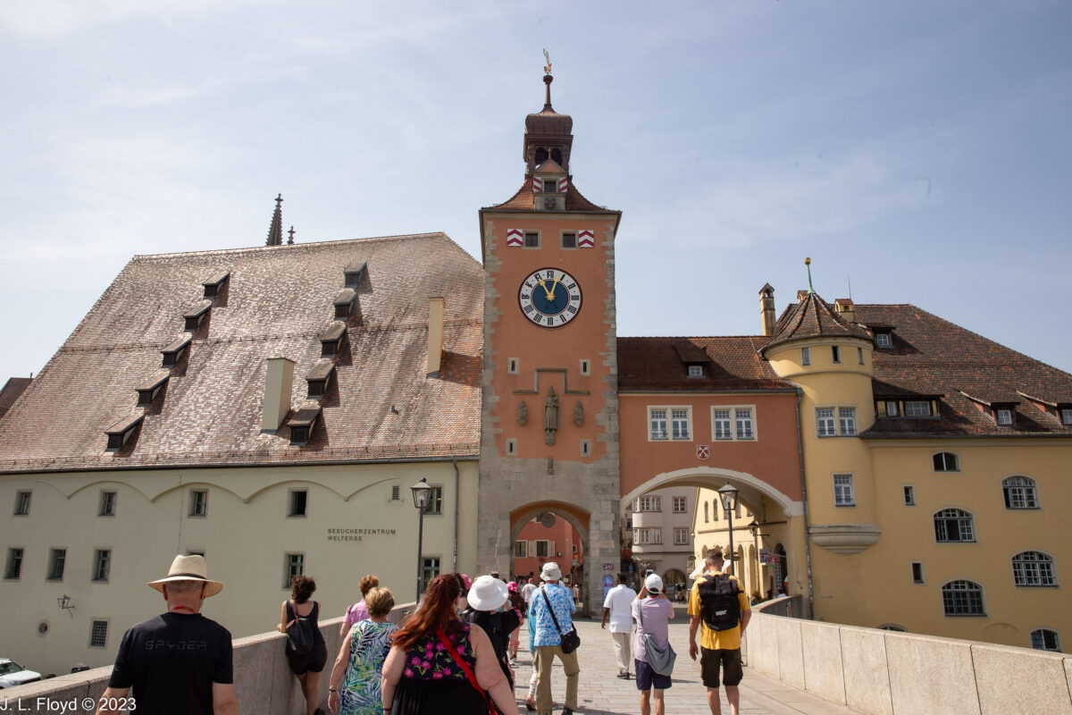
At the south end of the Stone Bridge is the Bridge Tower (Bruckturm), built around 1300. It has a clock, added in 1648, and an arch through which one enters the Old City. It is in the middle of a cluster of buildings which includes the Salzstadel (salt warehouse) on its left (east) and the former toll house (originally a chapel) on its right.

To the east of the Salzstadel is the Historische Wurstküche, Historic Sausage Kitchen, about which more later, and a little further down the riverbank is the Anlegestelle Donauschifffahrt, or Danube Shipping Wharf, which appears to be the most likely place where river cruise ships such as the Monarch Queen tie up when water levels are high enough for them to come to Regensburg. (They would then turn around and go back rather than continuing west under the Stone Bridge.) There was in fact a river cruise boat tied up at the wharf, but it was smaller than the Monarch Queen. While we were crossing the bridge I saw (and photographed) a very odd-looking craft, long and narrow and looking a bit like a Venetian gondola, with two very long poles or oars (they had flat blades on the ends) hanging on the stern. The boat pushed off the wharf, then shot under the bridge and off to the west. My guess is that it was an excursion boat of some sort, and the long poles or oars were there to provide a way of pushing off sand banks or away from navigational hazards, perhaps even to paddle the boat if the motor should fail. Later I found out that there are day cruises to the Walhalla memorial in Donaustauf which leave from the same wharf.

Passing under the Bridge Tower arch, we entered the Old City on Brückstrasse, Bridge Street, where the first house on the right had a prominent round tower on the corner. I had of course seen such towers on residential buildings in Germany and Austria before, but they seemed ubiquitous in Regensburg; I saw at least one of them on almost every street corner we passed in the Old City.

Regensburg is a very old city and was important even in Roman times. In 179 AD Emperor Marcus Aurelius had a major new camp called Castra Regina built at what is today the Old City of Regensburg. All that remains of that camp today are the ruins of the Porta Praetoria, which was the main gate of the fortified camp: a pile of stone blocks that have been cleverly integrated into what used to be the Bishop of Regensburg’s palace. Some of the stone blocks constitute part of the lower section of a corner tower, and others have been used to form an archway for a portal nearby.

From the Porta Praetoria, our guide led us west toward the city center. On the way we passed the Goliath House, a “city castle” built in 1260 for a patrician family. It is noteworthy chiefly for a huge mural of the battle between David and Goliath on the street side of the building. The painting, created in 1573 by Melchior Bocksberger, must have been refreshed, renewed and repainted several times over the centuries since it looks like it was done yesterday. Our guide informed us that Oscar Schindler, of Schindler’s List fame, had lived in the Goliath House for a while after World War II before emigrating to Argentina.

As we continued west along Goliathstrasse, I caught sight of a high tower with Gothic windows on a side street and paused to take a picture. This turned out to be the Baumburger Turm, a 7-story tower constructed during the 13th century. During that era there was competition among the patrician merchant families of the city as to who could build the highest and most grandiose family residence. The Baumburger Turm, at 28 meters (92 feet) high, is only the second highest — the Goldener Turm (Golden Tower) on Wahlenstrasse, which we would see later, tops it at 50 meters or 164 feet — but it is considered to be the most beautiful of the 20 surviving towers. It was built in 1270 by the Ingolstetters, one of the great patrician families of the time, but in the 14th century it was acquired by the Baumburgers, and their name stuck.

Emerging from Goliath Street, we found ourselves in the Kohlmarkt, a square which in days of yore had been the place where charcoal, a very important commodity for blacksmiths and everyone else, was sold. As far as I could tell, charcoal is no longer being sold there; instead it is a pleasant area to relax and enjoy an ice cream or coffee at Crema Gelato or lunch at one of the several cafés located there. It is also the site of a fountain called the Lebensbrunnen, or Fountain of Life. This is not part of the historical ambience of the square but a modern implant, in the form of a granite cup with melting sides, such that it gives the appearance of a grotto. Water spouts below the cup fill a basin which in turn spills into four smaller basins around the base. The fountain is the work of sculptor Günter Mauermann and was installed in 1985 as part of a city beautification project.

Kohlenmarkt leads right into the Rathausplatz, the seat of city government in medieval and early modern times. There is located the Altes Rathaus, the Old City Hall, which consists of several separate structures, built at different times in different styles. The oldest is the 55-meter (184 feet) tall Council Tower, built in the middle of the 13th century in the style of the patrician family towers such as the Baumburger Turm. Next came the Reichsaale building, constructed around 1320, to the west of the Council Tower. It was originally intended as a free-standing building for hosting municipal assembly and festival hall, but it soon found another use. The second story was originally accessed only via an outside staircase, but this was remedied in the 15th century by the construction of the Portal building, which provided inside access to the second floor and in 1564 was extended to connect to the Council Tower as well. Also in 1564 a new Baroque wing was added to the complex on the east side of the Council Tower.

But this was not the end of the story. In the second half of the 16th century Regensburg became the preferred meeting place of the Reichstag (legislature) of the Holy Roman Empire. The city fathers felt an obligation to give the Rathaus complex an appearance commensurate with its importance. One way of doing so was by painting the buildings, and in 1575 the town council gave Melchior Bocksberger, the same artist who painted the mural on the Goliath House, a commission to do something similar for the Rathaus. Unlike the Goliath House murals, however, his paintings on the Rathaus buildings have long since vanished.

To the east of the Rathausplatz, on Kohlmarkt, another structure, called the Market Tower, had been standing for centuries. In 1706 it burned down, and a few years later, in 1721, a new southern extension of the Baroque wing of the Rathaus was built on its foundations. As well as municipal offices, this edifice now houses a restaurant called the Ratskeller.

The Imperial Diet, the Reichstag, met in the Reichsaale, which has an elaborate bay window on its western façade, where the Emperor appeared on occasion to make proclamations and receive the homage of the people. After 1594 the Reichstag met exclusively in Regensburg, which in effect became the co-capital of the Holy Roman Empire with Vienna, and after 1663 it became known as the Perpetual Reichstag because it was in permanent session, never dissolved. It was also never a real representative legislature, but in effect only a convocation of the Imperial Estates, i.e. the territorial and ecclesiastical princes and Imperial free cities, which meant in practice — at least in its later years — an assembly of the ambassadors of the constituent states of the Holy Roman Empire.

Directly across Rathausplatz from the Ratskeller we found the Café Prinzess, which claims to be the oldest coffeehouse in Germany, operating continuously since 1686. A bit skeptical of the claim, I did a little online research later on and found that the earliest coffeehouses in Germany were opened in Bremen and Hamburg in the 1670s — which would seem reasonable, since these cities are closer to the Atlantic and therefore would be more likely to be exposed to imports from the New World before inland locations such as Regensburg. Another coffeehouse was opened in Nuremberg in 1686, the same year as the Café Prinzess. So the Prinzess’ claim is perhaps legitimate, as long as one qualifies the area as South Germany rather than Germany in toto.

From the Altes Rathaus our guide led us south on Wahlenstrasse – “Election Street” – toward Neupfarrplatz (New Parish Square). The main attraction on Wahlenstrasse is the Goldener Turm (Golden Tower), the highest of the medieval family towers – not only in Regensburg, but the highest north of the Alps. Its construction was begun in 1250 by the Waller (or Woller, nobody seems to know for certain) family, but the upper stories were completed later, in the 14th century, and the pyramid roof around 1600. The name “Goldener Turm” has nothing to do with any material used in the construction of the tower, but rather with an inn by that name which existed there in the 17th century.

As I’ve already mentioned, the Market Tower on Kohlmarkt burned down in 1706. It had been serving as the city’s watchtower, and with its demise, the Golden Tower was pressed into service as its replacement. Various modifications were made to make it more accessible and comfortable for the guards manning the tower.

In 1985 the Golden Tower was renovated and given over to the local student union to serve as a student housing facility for the University of Regensburg. It has 43 apartments, most of them in shared-living arrangements where the occupants share a common kitchen and bathroom.

Our guide, Paco Garcia, showed us into the attractive courtyard of the Golden Tower, which is surrounded by Renaissance arcades on three sides and has a dogwood tree in one corner. Parking is available for bicycles in the courtyard, but cars are not allowed.

Resuming our progress on Wahlenstrasse, we continued south to Neupfarrplatz. It came as a surprise to me – not being an expert on German history – that Regensburg was a major center of the Protestant Reformation in Germany. I hadn’t known that by 1542 the town council was entirely Lutheran, and in that year the city officially adopted the reformed faith. Catholics were in the minority and were deprived of civic rights, though they were not driven out (that only happened to the Jews, in 1519). The Bishop of Regensburg maintained his seat, and the Catholic cathedral continued to operate, along with several abbeys. The Imperial Diet continued to meet in Regensburg. Emperor Charles V, a devout Catholic who was determined to roll back Protestantism in the Holy Roman Empire, continued to show up in Regensburg in the course of his official activities and sometimes stayed for extended periods.

Back in 1519, as I already noted, the good people of Regensburg had, in their immeasurable kindness and mercy, decided to drive out the Jews living there. Actually this sentiment had been accumulating for some time, and both the bishop and the town council had repeatedly applied to the Emperor to be allowed to expel the Jews, but Maximilian I, the Holy Roman Emperor at the time, had refused permission. In January 1519 Maximilian died, and a month later the Regensburg city council, taking advantage of the interregnum, took matters into its own hands. The Jews were given two weeks to leave the city. Their houses and their synagogue were razed to the ground. Meanwhile, plans had been drawn up to build a new church on the site of the synagogue, and construction began immediately, using rubble from the demolished Jewish buildings. At that time Regensburg was still Catholic, and the new church was to be named St. Mary’s. Then, in 1528, funds for the construction ran out and work had to be halted, leaving the church only partly complete. When Regensburg converted to Lutheranism in 1542, the city council decided to make the incomplete St. Mary’s the first Protestant church in town and renamed it the Neupfarrkirche, or New Parish Church. But it was not finally completed until 1860.

The Neupfarrplatz, which surrounds the Neupfarrkirche, is thus the old Jewish quarter of Regensburg. At its west end, where we came in from Wahlenstrasse, stands the elegant Baroque Reichsstadtbrunnen, or “Imperial City Fountain”, which dates from 1721. Between the fountain and the New Parish Church is the Synagogengrundriss, also known as the Misrach monument. In 1995-97 excavations were conducted which unearthed the remains of the old Jewish synagogue on Neupfarrplatz; a decade later, an Israeli artist named Dani Karavan created on that site a replica of the floor plan and foundation of the synagogue using white granite blocks.

In 1611, on the east side of Neupfarrplatz, a wooden structure called the Hauptwache (Main Guard Station) was built to house the town militia. This body was made up of citizen soldiers, although after 1663 the city hired mercenaries to fulfill their duties instead. These duties included maintaining order in the city, performing guard duty at the gates, and providing military contingents for Imperial forces in times of crisis as required, for example during the siege of Vienna by the Turks in 1683.

In 1820 the wooden Hauptwache was replaced by a stone building with a Tuscan portico, supported by eight columns made of green sandstone. In 1875 a second story was added to the house. After World War II, the building — by this time known as the Alte Wache (Old Guard House) — was used to house the city library, but in 1973 it was demolished to make way for a new indoor shopping mall, the Galeria Regensburg Neupfarrplatz. However, the façade was retained and incorporated into the new mall, and thus still may be seen today.

From Neupfarrplatz it was just a short walk northeast to Domplatz —Cathedral Square. The Gothic cathedral of Regensburg was begun in 1280, after the previous one burned down, at a time when the economic fortunes of the city were at their height. The design was grandiose – a French architect was hired for the purpose, so the cathedral was built in the French Gothic style. It is the only Gothic cathedral in Bavaria. Construction continued for over two centuries, but then Regensburg fell upon evil days; economic downturn, religious upheaval and civil unrest led to the cessation of work on the cathedral in 1520. Although a few additions and modifications were made during the next three centuries, it remained unfinished, and in particular the towers with their spires remained mere stumps, about half as high as planned. It was not until the 19th century that any further progress was made. Following the Napoleonic Wars, Regensburg was incorporated into the Kingdom of Bavaria, and its King, Ludwig I, started taking an interest in the cathedral. Ludwig commissioned a neo-Gothic renewal in the 1830s, and in the 1860s the cathedral was finally completed with the addition of the towers and spires. In honor of his patronage, an equestrian statue of King Ludwig erected in 1903 stands on the south side of the cathedral.

We did not see the inside of the cathedral because it was now time for lunch, and our luncheon spot was right next door to the Cathedral. It was the old bishop’s palace, now a 4-star hotel, the Bischofshof am Dom. It has an open-air restaurant, the Bischofshof Biergarten, in its courtyard, and there we enjoyed an excellent lunch of beer and sausages.

After lunch we were turned loose to wander about as we pleased, with the proviso that we wander back to the Walhallabahn Museum to reboard our bus by the appointed time. I chose to wander west on Goliathstrasse toward Keplerstrasse, a street named after a famous astronomer who had once lived there. Keplerstrasse is a block or two north of Goliathstrasse and to get there, I took a right turn at Zieroldsplatz, which runs along the east side of the Altes Rathaus. On Zieroldsplatz there is a statue of Don Juan of Austria, which I had seen from Goliathstrasse earlier, but now I had a chance to stop and get a better photo of it, which I did.

I would not have expected to see a monument to Don Juan of Austria in Regensburg or anywhere in Bavaria, because his career was associated almost entirely with Spain and not at all with Germany — except for his birthplace, which was Regensburg. It turns out that Emperor Charles V made his last visit to Regensburg in 1546, during the Schmalkaldic War, when he was attempting to subdue a league of unruly Protestant princes. He stayed at the Goldenes Kreuz (Gold Cross) Inn on Haidplatz, a favorite hostel for princely visitors, and while there had an affair with a woman named Barbara Blomberg. His wife, Isabella of Portugal, had died in 1539 and he had not remarried. Barbara, as the daughter of an artisan, was a commoner and would not have been considered eligible to marry royalty. The birth of Don Juan, which occurred on January 24, 1547, was kept a closely guarded secret. Charles V shortly left Regensburg and won an overwhelming victory over the Protestants at the Battle of Mühlberg in April 1547. Don Juan was taken to Valladolid, Spain, in 1554 to be raised by a Spanish noble family. He did not meet his father until just before Charles’ death in 1558. In his last will, Charles expressed an intention to have the boy take holy orders and pursue an ecclesiastical career.

Don Juan, it turned out, had other inclinations, which were toward a military vocation. He earned his spurs fighting pirates in the Mediterranean and then by suppressing the rebellion of the Moriscos in Spain in 1568-71. In 1571, he was made commander-in-chief of the armada of the Holy League, an alliance between King Philip II of Spain (Don Juan’s half-brother), the Pope and other Christian powers against the Turks. On October 7, 1571, the Christian forces met and annihilated a much larger Turkish fleet in the Battle of Lepanto, and Don Juan was hailed as a hero. A statue of him was sculpted and installed in Messina, Sicily, where the Christian fleet had sailed from. The statue in Regensburg was erected in 1978 and is an exact copy of the one in Messina.

Don Juan was less successful in his next major assignment. In 1576 Philip II sent him to quell the revolt of the Netherlands, which the king’s uncompromising religious policies had provoked. He was initially successful, winning a great victory over the Protestants in the Battle of Gembloux. But six months later he suffered a defeat at Rijmenam, and two months after that he contracted a fever (probably typhus) and died on October 1, 1578, at the age of 31. He is buried in the Escorial, Philip II’s monastery-palace near Madrid.

From Zieroldsplatz I continued north to Fischmarkt, which if one turns west becomes Keplerstrasse. At Keplerstrasse 5 I found the Keplergedächtnishaus, or Kepler Memorial House. I was a bit disappointed to learn that Kepler lived there for only a month in 1630. He lived most of his life, and did all his significant work, in Graz, Linz and Prague.

Kepler was born in 1571 in another Free Imperial City, Weil, in the German state of Württemburg, and attended the University of Tübingen, also in Württemburg. He wanted to become a minister (Protestant), but poverty, along with his skills at mathematics and astronomy, led to his taking a position as astronomer with a Lutheran school in Graz, the capital of the province of Styria in southern Austria, in 1594.

It was Kepler’s misfortune to live during the height of the Catholic Counter-Reformation, when the Habsburgs were undertaking a concerted effort to roll back the Protestant tide in Germany. Leading the charge was the Archduke Ferdinand, who became ruler of Inner Austria (Styria, Carinthia and Carniola) in 1597 and the next year expelled Protestant teachers and preachers from his domains. (He would eventually become Holy Roman Emperor in 1519.) By that time Kepler had made a name for himself and was able to land a job with the Imperial Court Astronomer, Tycho Brahe, in Prague. When Brahe died suddenly in 1601, Emperor Rudolf II immediately appointed Kepler to step into Brahe’s shoes. Rudolf was mostly interested in astrology – in those days astronomy and astrology were not distinct disciplines – and Kepler was required to cast horoscopes for the monarch. Nevertheless during his time in Prague he published some of his most significant works, including Astronomia Nova (1609), in which he set forth his laws of planetary motion, which asserted that planets orbited the sun in ellipses rather than circles.

Although Rudolph’s successor Matthias confirmed Kepler’s position as court astronomer after his predecessor’s death in 1612, the imperial treasury was empty and Kepler’s salary was not being paid. In the same year Kepler accepted a position in Linz as mathematician to the states of Upper Austria, without resigning as court astronomer. Kepler’s residence in Linz was not devoid of travail. Although he steadfastly refused to convert to Catholicism, his independent views on religion earned him the enmity of the Lutherans, who made what trouble they could for him. This included an accusation of witchcraft against Kepler’s mother, still living in Württemburg, and he had to take several months off work to defend her, in which he was successful. The Thirty Years’ War, which broke out in 1618, at times threatened to engulf Linz, which was besieged in 1626-28. Amidst all the chaos, Kepler’s patrons had other priorities than astronomy and failed to come up with the sums they had committed to pay. In 1830, Kepler decided to seek restitution from the Imperial Diet, and on October 8, 1830, he set out for Regensburg, where it was meeting. Worn out by the rigors of a long ride on horseback, he soon fell sick and died a month later, on November 15, at the age of 59, in the house he had rented, on the street that many years later was named after him.

I continued down Keplerstrasse a little way, then turned around and went back to Fischmarkt, taking photos as I went. There was much to see: elegant Baroque buildings with rounded corner towers and bay windows; upscale restaurants, cafés and pubs; a ceramics shop with exquisite wares; and two pretty fountains, the Fortitudobrunnen on Fischmarkt and the Wiedfangbrunnen at the corner of Goldene-Baren-Strasse and Am Wiedfang alley. The Fortitudo Fountain is supposedly part of a trio representing the cardinal civic virtues of Fortitude, Justice and Peacefulness. (I did not see either of the other two, assuming they still exist.) Fortitude is depicted as a figure of a youth standing on a dolphin, holding a fish in his left hand. The Wiedfangbrunnen is actually an old well, built in 1610 and renovated many times over the years, so that it looks almost like new. It is no longer used as a well, of course, and is blocked by a grating.

At Am Wiedfang I took a left and went north to the riverbank, with the aim of shooting some photos of the Stone Bridge from the side. I noticed that the closer I drew to the river, the more graffiti I saw, and when I reached the riverfront, the graffiti were ubiquitous. So I photographed the graffiti, too. I gather that graffiti are a common sight in European cities these days; I had seen them in Spain and Portugal in 2017, and in Vienna a few days earlier. Disregarding the graffiti, though, the south bank of the Danube in Regensburg has a nice long promenade, with stone benches where people can take a break.

By now it was time to return to the bus and say farewell to the marvellous medieval city of Regensburg. Before I crossed back over the Stone Bridge, I stopped by the Wurstküche. I didn’t have time or appetite to sample any of its famous sausages, but I did take a couple of pictures.

The Historic Sausage Kitchen of Regensburg began as the construction office for the Stone Bridge in 1136. When the bridge was finished in 1146 the little building was turned into a restaurant which served boiled meat. The customers were dockers, sailors, cathedral workers and other local people. Around 1800 the menu was changed to feature charcoal-grilled sausages. Currently it serves around 6,000 sausages per day. You can get them with sauerkraut and mustard; other dishes are available as well. The tiny restaurant only seats 35 people, but there is an outside dining area which can be used in fair weather.

The Regensburg Sausage Kitchen has been in business continuously for over 800 years, and claims to be “the oldest continuously open public restaurant in the world.” But the day before, I had been assured that St. Peter’s Stiftkulinarium in Salzburg was the oldest restaurant in the world, having been opened around 800. Which claim should I believe? Perhaps it depends on the wording. Maybe St. Peter’s was not continuously open during the entire period of its existence, or perhaps it was not public for part of its existence. Regardless, the Wurstküche has been around for a long time.

Crossing back over the Stone Bridge, I observed some sunbathers relaxing in the grassy area on the Stadtamhof side, as well as people taking a dip in the river there. This locale turned out to be a park with the formidable name of Naherholungsgebiet Steinerne Brücke, “Local Recreation Area Stone Bridge.” Lacking a sandy beach, the city of Regensburg instead provided this pleasant grassy area for sunbathers and picnickers, pleasantly shielded by wooded Wöhrde Island from the traffic on the main branch of the Danube.

By this time I was quite worn out and ready to board the bus back to Vilshoven – I think I slept most of the way. Back on the Monarch Queen, we had some festivities to celebrate our last night on the ship, but I stole some time to take a few last pictures of the river as well as some telephoto shots of the town of Vilshofen from the top deck of the ship. As I was thus engaged, a pair of lovely white swans swam up near the riverbank next to the Monarch Queen. It was a delightful conclusion to a memorable day and a fairytale cruise on the Danube.

Categories
Danube River Cruise, June 2023

Salzburg, June 21, 2023: Afternoon

I figured that the most interesting thing I could do after lunch would be to investigate the Hohensalzburg Fortress on top of its mountain, so I set out in its general direction and immediately found myself in the St. Peter’s Abbey cemetery, known as Petersfriedhof. I’m not normally a great fan of cemeteries, even historic ones, but Petersfriedhof proved to be a very unusual and beautiful place and I’m glad I didn’t miss it.

The cemetery is actually older than the abbey, having been used as a burial place by Christians from late antiquity. The graves are beautifully decorated, and when I was there in June the grounds were lush and verdant, with flowers in bloom throughout. But what really Petersfriedhof an extraordinary place is the chapels, the arcade crypts and the catacombs. At the back of the cemetery, right up against the mountain, is a long row of crypts fronted by elegant wrought-iron gates, containing tombs where the members of wealthy and aristocratic families are buried. These crypts are attractively decorated in various ways, some with frescoes, others with elaborate headstones, and included in the rent paid for the crypts is a floral service which places fresh flowers in each crypt every month.

Carved into the mountain above the crypts are catacombs, thought to have been built in the Roman era, possibly by Christians as places of shelter and refuge from persecution.

Among the notable persons buried in Petersfriedhof are the composer Michael Haydn, younger brother of Joseph Haydn; Maria Anna “Nannerl” Mozart, Wolfgang’s older sister; and Harry J. Collins, an American general who led the 42nd Infantry Division in the invasion of Germany at the end of World War II, liberated the Dachau concentration camp, served as military governor of western Austria after the war, and later retired to Salzburg, where he died in 1963.

Inevitably, Petersfriedhof also figures in The Sound of Music, which has a famous cliff-hanger scene set there: with the aid of the Mother Abbess of Nonnberg Abbey the von Trapps hide from the pursuing Nazis in the catacombs as they prepare to escape to Switzerland. (This episode is of course entirely fictional.)

After meandering around Petersfriedhof a bit, I came out on the north end of a small triangular plaza where I found an old waterwheel, slowly turning under the impulse of a stream that runs underneath. This wheel, or Wasserrad in German, powers the mill of St. Peter’s Abbey Bakery next to it. It’s a proud relic of an older time when technology was relatively primitive and yet provided an efficient and reliable way of harnessing the forces of nature. According to a local guide, there is a local legend to the effect that the Wasserrad was once part of a series of “talking” wheels, believed to whisper prophecies to those who listened closely on moonlit nights.

Across the court from the waterwheel and its bakery stands a statue of the Bohemian martyr St. John of Nepomuk (Johannes or Jan Nepomuk, 1345-1393). He is venerated in the Roman Catholic Church as the “martyr of the seal of confession,” because, as the confessor of the Queen of Bohemia, he supposedly refused to divulge the secrets of her confessions to King Vaclav IV, who had him drowned in the Vltava River in retaliation. Because of the manner of his death, he came to be considered a protector against floods and drowning, and touching his statue is thought to bring good fortune, especially for those about to embark on a journey over water.

Exiting from the courtyard of the Wasserrad into a narrow street called Festungsgasse – “Fortress Alley” – I shortly came to the lower station of the Festungsbahn, the funicular railway that transports people to and from the Hohensalzburg fortress. Near the entrance to the Festungsbahn is a pool with several intriguing fan-shaped contraptions which appear to be windmills operating water pumps, perhaps to irrigate the vegetation in the cemetery – that’s my guess, because I didn’t see any signs or plaques describing them. But tucked in behind the pool, next to the Festungsbahn station, is a small rock-walled tunnel, apparently quite old, called the Liebesgrotte, or Love Grotto. At the entrance there is a plaque which reads, in old-style German letters, “Küsst man sich in der ‘K & K Liebesgrotte’, wird die Liebe ewig währen,” and beneath it in English, “One kiss in the ‘love grotto’ and your love will be everlasting.” A second plaque reads “One Kiss: 1€”. A box beneath the second plaque with a slot in the top makes it obvious that one is expected to drop a 1 euro coin in the box for the privilege of kissing in the Love Grotto, though there is nobody standing by to enforce it. The “K & K” in the German inscription stands for “Kaiser und Königliche,” i.e. “Imperial and Royal,” referring to the fact that the ruler of the Dual Monarchy was both Emperor of Austria and King of Hungary. Since the Dual Monarchy was established in 1867 and ended with the First World War, the reference to it would imply that the plaque was made during that period; but the fact that it is also in English suggests that it was made much more recently, since large numbers of English-speaking tourists would not have been common until some time after World War II. So I found it a little puzzling. In any case, since my wife was absent, I didn’t have an opportunity to test the promise of the Love Grotto.

The Festungsbahn has been in existence since 1892, although it has been updated several times since then, most recently in 2011. It is a single-track railway with a passing loop, and is 191 meters (627 feet) long; 99 of those meters (327 feet) are vertical, with a maximum grade of 62%. Two cars are operated, with a maximum rated capacity of 55 passengers each; I found it hard to believe that 55 passengers could fit into one car, and certainly not more than 20 were in the each of the cars I rode in. The ride up to the fortress takes only one minute.

It turns out that there is another railway that provides access to the fortress; it is used for hauling supplies, and it is far older than the Festungsbahn. The Reisszug is a privately operated cable railway running from the Nonnberg Abbey on the east side up to the central courtyard of the fortress. It was already in operation by the early 16th century, which would make it the oldest cable railway – or perhaps the oldest railway of any kind – still in existence. The cars then were equipped with wooden wheels and ran on wooden rails, and human or animal power was used to pull them to the top with hemp ropes. I pity whomever was called upon to provide the motive force, because the gradient is 65%. This situation prevailed until 1910, when the railway was updated with steel rails, steel cables and an electric motor for traction. It has only one car, which can carry 3 passengers or 2,500 kilograms (5,500 pounds) of freight.

The Hohensalzburg, sitting atop the Festungsberg (Fortress Mountain) at an altitude of 506 meters (1660 feet), is one of the largest medieval castles in Europe. Although there was a Roman fortification atop the hill in ancient times, construction of the medieval fortress began in 1077 under Archbishop Gebhard von Helfenstein. During the Investiture Controversy, which pitted the Holy Roman Emperor against the Roman Catholic Papacy, Gebhard was a supporter of Pope Gregory VII against Emperor Henry IV. Fearing the prospect of Henry’s wrath, and anticipating the need to defend his realm against Imperial forces, Gebhard had a basic motte-and-bailey castle – a bastion or keep with wooden walls – built atop the Festungsberg. It did him no good; Henry chased Gebhard out of Salzburg and installed an anti-archbishop in his place. (Gebhard eventually regained his archbishopric in 1086 with the support of the powerful Duke of Bavaria.)

The fortress was greatly expanded in the 15th and early 16th centuries, just in time for the Reformation. This was fortunate for Prince-Archbishop Matthäus Lang von Wellenburg, Prince-Archbishop from 1519 to 1540, who was besieged in the fortress in 1525 by local insurgents — the only time the fortress came under siege during its entire existence. Lang, a strong supporter of the Catholic Church and Emperor Charles V, had made himself unpopular in Salzburg, and a group of miners, peasants and townspeople wanted to get rid of him. But they failed to take the fortress, and the Archbishop called in help from outside to suppress the revolt. During the Napoleonic Wars, in 1800, French troops took the fortress, but they did not need to besiege it, because it was surrendered without a fight, and the last Prince-Archbishop, Hieronymus von Colloredo, Mozart’s nemesis, ran away to Vienna. Unfortunately Mozart was no longer alive to savor the Archbishop’s discomfiture.

After the Napoleonic Wars, with the imposition of direct Habsburg rule on the former archbishopric of Salzburg, the fortress became Imperial property and was used as a military barracks, storage depot and prison until 1861, when the government turned it over to the city of Salzburg. After the building of the Festungsbahn funicular railway in 1892, it became a major tourist attraction. However, during World War I it was again used as a prison, this time for Italian prisoners of war; and again in the 1930s, when the Austrian government incarcerated unruly Nazis there until the Anschluss of 1938, after which the inmates took over the asylum, in effect.

Since World War II, Hohensalzburg has become one of the pre-eminent tourist magnets in a city which is full of fascinating attractions. The fortress contains several enticing museums, which I would have loved to visit, but I only had enough time to do a superficial walk-through of the passages and courtyards. Even that took over an hour; I could have spent an entire day there. The Prince’s Chambers in the Hohe Stock are said to be quite impressive; on the ceiling of one room, the Golden Chamber, is a simulation of the night-time sky, consisting of gold stars on an azure background. I also regret to have missed the Salzburg Bull, which is not a bovine but a 500-year-old wheel-driven auto-playing barrel organ. But you can see and listen to it, as I did, on YouTube, via the fortress’ website.

The Salzburg Bull was installed during the tenure of Prince-Archbishop Leonhard von Keutschach, who was responsible for a number of major improvements to the fortress. There is a monument to him in the wall of St. George’s Chapel in the main courtyard of the fortress. He was elected Archbishop in 1495, and proved to be a highly effective administrator; during his reign Salzburg became one of the richest principalities in Europe. He stabilized the archbishopric’s finances and undertook important economic initiatives, including the reorganization of the salt trade and the development of silver and gold mining. He strengthened the defenses of the city and the fortress, and had several new castles built in his domains to improve its security.

But there was a dark side to his reign also. In 1404 the Jews had been expelled from the city, but since then had been allowed to return; Leonhard expelled them again and destroyed their synagogues. In 1481 Holy Roman Emperor Frederick III had granted the citizens of Salzburg the right to elect their own city council and mayor, a reform which was most unwelcome to the Archbishops. But Leonhard found a solution to that: in 1511 he invited the city officials to a posh banquet, where he had them clapped into prison and held there until they agreed to renounce the rights granted by the Emperor. He was also notorious for nepotism, placing his relatives in important positions throughout the archdiocese. Perhaps on account of these transgressions, in 1514 the Pope appointed a coadjutor to the archbishop. A coadjutor in the Roman Catholic Church is a kind of co-bishop appointed to assist in the administration of the diocese, and perhaps to keep an eye on the bishop if he is thought to be in declining health, or is incompetent or suspected of malfeasance. A coadjutor also has the right to succeed the current bishop on his retirement or death. Leonhard von Keutschach’s coadjutor was Matthäus Lang von Wellenburg, and the two did not get on well. The situation was resolved, however, when Leonhard died in 1519 and Matthäus Lang succeeded him.  As I have already noted, Lang was no more popular with the citizenry of Salzburg than his predecessor, but he greatly benefited from Leonhard’s upgrades to the fortress, which helped him to weather the revolt of 1525.

Two of Leonhard’s predecessors, Burkhard von Weisbriach (1461-1466) and Bernhard von Rohr (1466-1481), had already made some significant additions in 1462, consisting of ring walls and towers. Leonhard picked up where they had left off, adding new walls and towers, strengthening the existing ones, and installing cisterns to safeguard the water supply. He was also responsible for the creation of the luxurious Prince’s Chambers in the Hohe Stock, for the construction of St. George’s Chapel, and for the acquisition of the Salzburg Bull organ. The Reisszug cable railway was established during his tenure. It was in his time that Hohensalzburg essentially acquired the form in which we see it today.

In addition to all the other enhancements he sponsored, Leonhard gave the fortress a new coat-of-arms, with a rather whimsical design taken from his own coat of arms, which depicts a lion and a turnip. The turnip was part of the von Keutschach family heritage; their coat-of-arms displays a white turnip on a black field. Although the coat-of-arms is displayed prominently on the wall of the chapel, I missed it and didn’t get a photo, but a good one can be seen on the Hohensalzburg page of the Exploring Castles website.

As one might expect, the views of the city and countryside from the parapets of Hohensalzburg are magnificent, and I did my best to shoot a full 360-degree panoply of photos in the limited time I had.

The view to the north overlooks the Aldstadt, the Old City, in the foreground, with the Cathedral, St. Peter’s Abbey, the Franciscan Church and the University Church all prominently in view. Behind them the Salzach River winds through the city, heading toward its rendezvous with the Inn River far in the north. Across the Salzach one may discern the major landmarks of the Neustadt: the Kapuziner Kloster – Capuchin Monastery – on the Kapuzinerberg; the Dreifaltigskeitkirche (Holy Trinity Church), a Baroque church with a large dome; the Andräkirche (St. Andrew’s Church), a neo-Gothic church on Mirabellplatz; and, of course, the Mirabell Palace with its gardens.

Immediately to the west lies Mönchsberg – Monks’ Mountain – named after the monks of St. Peter’s Abbey. It extends 500 meters () from the Festungsberg and is 508 meters ((1667 feet) high at its highest point, but its top is a plateau rather than a peak. It is largely unspoiled, with extensive woods and meadows and many hiking trails, making it a popular recreation area for locals as well as a tourist magnet. It has a number of picturesque old fortifications and several small palaces, including the Marketenderschlössl, formerly owned by the Catholic Pallotine Order but now a study center run by the University of Redlands in California. As I have noted in my previous post, half of the Salzburg Museum of Modern Art (Museum der Moderne) is also located on the Mönchsberg.

To the east of the fortress may be seen the Nonnberg Abbey, where Captain von Trapp and Maria from The Sound of Music were married in real life; the Sportunion Sportplatz and the Sportzentrum Salzburg Mitte, a sports complex; the Nature and Life-Sciences Department of the University of Salzburg; and various other educational institutions.

The most stunning views for me were toward the south. That way lay the Berchtesgaden Alps, Untersberg, and the Tirol. The south view was filled by the Untersberg massif, with its lopsided peak of Berchtesgaden Hochthron. To the southwest and southeast, the Alps seem to march off endlessly into the distance.

At the foot of the Festungsberg, beneath the fortress ramparts, there is a broad squarish green space with a solitary small house in the middle. I found out later that this was the Krautwachterhaus (“Vegetable keeper’s house”), so called because from the time of its construction in 1380 down to the 19th century it was the dwelling of the caretaker of the vegetable gardens of St. Peter’s Abbey. The vegetable gardens are now a park called Krauthügel (“Veggie Hill”), and the house is a monument protected by law. There is also a local legend that the house has no other dwellings near it because it once belonged to the city executioner, and nobody wants to live near an executioner; but this is apocryphal.

The park is also the site of the Krauthügel Art Project. Supposedly, every summer an artist affiliated with the Project creates a new work of art and displays it there. What I saw was a figure made of lines of white material – it turned out to be concrete – taking the shape of a square, with lines running from the edges of the square and forming a design in the middle. I had no idea what to make of it, but from later research I discovered that the name of the artwork is “Fallen Star,” and that is what the design in the middle is supposed to represent. The artist is an American, Paul Wallach, who lives and works in Paris. From my high perch on the parapets of Hohensalzburg, I could see no evidence of any other artworks in the park, and it seems that the Fallen Star has been there since 2018.

After descending from the fortress, again via the Festungsbahn, I had about a half-hour to get back to the rendezvous point at Marko Feingold Bridge by the appointed time of 3:45, so my picture-taking time was limited to quick pauses along the way. However, I did manage to see Kapitelplatz, which I had missed on the way in. This is the square just south of the Cathedral, and there I encountered a huge golden ball resting on an iron frame with a man standing on top clothed in what appeared to be dark pants and a flannel shirt. This is the Salzburg Sphaera, a work of art by the German sculptor Stephan Strahlhol (or Stangenhol, or Balkhol — he evidently goes by several different family names and nobody seems to know which is the real one). I felt sorry for the man standing immobile on top all day until I realized that he is just a statue of Paul Fürst, the confectioner who created the Mozartkugel in 1890, and the golden ball (Goldene Kugel in German) is a grandiose facsimile of a Mozartkugel. The Goldene Kugel, is made of reinforced fiberglass, weighs 2 tons, and sits on a wrought-iron frame weighing 3.5 tons. The statue on top weighs 300 kilograms (661 pounds) and the whole ensemble is 9 meters (30 feet) high.

There is no fence or other barrier around the Goldene Kugel and the lower part of its surface is within easy reach of a person standing next to it, so of course that expanse of the ball – which, if the ball were the Earth, would be about the area within the Antarctic Circle – is covered with graffiti. However, the graffiti extend up much farther than that, up to about the Tropic of Capricorn, 23° 26′ 22″ south of the Equator, so some people must have had ladders or stood on others’ shoulders to write their graffiti. The most prominent graffito was by someone from the city of Yaroslavl in Russia (a place which I visited in 1973 and where I walked on the ice-covered river Volga) and consists simply of the inscription “YAROSLAVLЬ 09.07.2019”. (The character Ь at the end of the city name is the result of a misguided attempt to retain the final Russian letter while transliterating the name into Latin letters. The usual way to represent the Russian letter Ь in Latin type is with an apostrophe, so the city name would come out as Yaroslavl’.)

Threading my way back to the rendezvous point through the narrow streets of the Altstadt to the Marko Feingold footbridge, I encountered a number of tempting establishments I would have loved to patronize if there had been time. On Goldgasse I passed a gin bar named the “5020 Destillerie” where the gin is distilled on the premises, and they will make drinks to go, which would probably be illegal anyplace in the USA. On Judenstrasse I came upon a café named the Goldene Kugel, after the artwork in Kapitelplatz. Looking it up online afterward, I found that it gets generally good reviews.

I made it back to the rendezvous point on time, boarded the bus and slept most of the way back to the ship. Thus ended my second visit to Salzburg, which turned out to be far more pleasant and edifying than the first.

Categories
Danube River Cruise, June 2023 Adventures Abroad

Salzburg, June 21, 2023: Morning

I have to confess that I was a bit apprehensive about going to Salzburg, because on my first visit there I had become a wanted criminal, and I was concerned that I would be recognized and detained in one of the dungeons of its grim fortress, never to see daylight again.

Let me relate the circumstances. In June, 1964 I had joined a small party of fellow-students at the Institute for the Study of the USSR in Munich, Germany, who wanted to go on a trip to Italy in a Volkswagen beetle. We set out and somehow found ourselves in Salzburg, where we decided to stop for lunch. We investigated this one place – I don’t remember what it was called, but I do remember it had a terrace, as well as a large parking lot. For some reason, we decided not to have lunch there – maybe it was too crowded, and we didn’t want to wait – so we got back in the car and started to drive away. On our way out we slightly sideswiped a Mercedes, putting a dent in the bodywork. The owner of the Mercedes was having lunch with several other people on the terrace, and they all jumped up and began shouting for us to stop and wait for them to come so they could get our insurance information. Instead we got the hell out of there as fast as we could, and made it to Italy and back to Munich without being detained in Austria.

Okay, I wasn’t really worried that the local police would recognize me after 59 years or even that they had any record of the incident after so long. But it was an unpleasant experience and I did not have a good memory of the city, or especially high expectations for my second visit. But Salzburg not only exceeded expectations; my visit there proved to be one of the most memorable experiences of the Danube cruise.

To be sure, Salzburg is not on the Danube. It is in the Alps of Upper Austria, 120 kilometers and a two-hour bus ride from the river. The Monarch Queen docked at Aschach, a small town west of Linz, to let us catch the bus for Salzburg, while it went on to Passau. Those who did not go on the Salzburg excursion got to see Passau that day instead. Sandie, unfortunately, was not feeling well enough to do either and stayed on the boat.

After an hour or so on the road, the bus stopped a rest area by a lake named Mondsee, where there is also a town by the same name. The rest area had a gas station and a nice motel, the Landzeit, with a restaurant. Mondsee is in the Salzkammergut, a resort area in Upper Austria east of Salzburg. I should mention that on the previous night (June 20) the Monarch Queen had entered Upper Austria, which is so named simply because it lies upstream on the Danube from Lower Austria. Both are separate states of the Republic of Austria, and so is Salzburg (the others are Vorarlberg, Tirol, Styria, Burgenland, Vienna and Carinthia).

The Salzkammergut is not an official administrative division of Austria but rather a vaguely defined region of salt mines – the name Salzkammergut means “salt demesne” – which were formerly owned and operated by the Hapsburgs. Salt was a very important commodity in pre-modern times because its sources, in inland areas, were relatively few and often remote from the consumers, so it had to be shipped long distances, making it expensive. In Europe salt-mining and sale was frequently a royal monopoly and a lucrative source of income for the rulers. So it was in Salzburg, which owes its name (meaning “salt-castle”) to its control of the salt trade on the Salzach River.

Mondsee, the lake, is on the border between the states of Upper Austria and Salzburg. The lake is about 9 miles long, is privately owned, and the owner, Nicolette Wächter, has put it on the market for 16 million euros.

It was in Mondsee that we would start hearing what would prove to be continual references to the musical The Sound of Music. Although I had seen the 1965 movie starring Julie Andrews and Christopher Plummer, I was not a great fan of it and didn’t remember much about it. I had indeed forgotten that the movie was set in Salzburg and partly filmed there. I was soon reminded. As the bus passed the town of Mondsee on the A1 highway, our guide noted that the wedding scene between Captain Trapp and Maria in The Sound of Music was filmed in the medieval cloister church of Mondsee Abbey. (In real life they were wed in Nonnberg Abbey in Salzburg.)

From then on, allusions to The Sound of Music hardly ceased. Our tour bus dropped us off at Mirabell Palace, a 17th-century Baroque affair with ornamental gardens. There we learned that the steps we had just come down from the street to the garden, and the stunning Pegasus fountain nearby, were a setting for a scene in which Maria and the children sang “Do-re-mi” dancing around the fountain and using the steps as a musical scale.

The builder of Mirabell Palace, Prince-Archbishop Wolf Dietrich von Raitenau (1557-1617), was a picturesque character who deserves some mention. He was elected archbishop in 1587 and, as an adherent of the ideas of Niccolò Machiavelli, ruled Salzburg as an absolutist Renaissance prince, with lavish expenditures on art and construction projects. His misfortune was that this was no longer the era of the Renaissance but of the Catholic Counter-Reformation. At first he enforced the measures of the Counter-Reformation rigorously, establishing the Capuchin Monastery as a stronghold against the Reformation and expelling the Protestants from his domain, but in the later years of his reign he relaxed his earlier posture, much to the dismay of the Vatican. In 1606, he built a palace on the north bank of the Salzach River for his mistress, Salome Alt, with whom he had fifteen children. But a few years later, he ran afoul of a much more powerful potentate, Duke Maximilian I of Bavaria, whom he challenged for control of Berchtesgaden. Maximilian prevailed, and Wolf Dietrich was deposed and imprisoned. His successor, Mark Sittich von Hohenems, booted Salome and her children out of her palace, and then renamed it Mirabella. In the next century, the palace was rebuilt in the Baroque style, and again in 1818 in Neoclassical fashion, giving it its present-day appearance.

We did not visit the interior of Mirabella Palace owing to lack of time, so we missed the acclaimed Marble Hall, which used to be the archbishop’s banquet and concert hall, and is now used for the same kinds of events by both public and private groups. Mozart performed there for his boss, Archbishop Hieronymous von Colloredo, whom he despised. It is still considered one of the most beautiful concert halls in the world.

From the palace, we proceeded south along the parterre of the Mirabell Gardens. The gardens were created somewhat later than the palace, in the late 17th century, during the administration of Prince-Archbishop Johann Ernst von Thun. Von Thun hired the noted architect Johan Bernhard Fischer von Erlach, a celebrated Baroque artist, for a number of projects in Salzburg, including laying out the Mirabell Palace Gardens, and he was responsible for the dominant feature of the parterre, the Four Elements Fountain. This consists of an octagonal basin with a single fountain in the center spewing a tall column of water vertically; around the fountain there are four groups of statues, depicting figures out of Greek mythology who are supposed to represent the four elements known to the ancients – Earth, Air, Fire and Water. The relationships between the elements and the statues are somewhat obscure in the absence of explanation, which I have provided in the captions of the pictures in the gallery following.

Farther south, there are two more groups of statues of ancient Greco-Roman deities, standing on two sets of stone balustrades that enclose the south end of the Mirabell Gardens. There is an inner balustrade for the goddesses and an outer one for the gods; both are split into two segments by the exit walkway. I photographed only the goddesses on the inner balustrade since the outer balustrade is screened by trees. All of the statues may be seen on the Salzburgwiki page for Mirabell Gardens, along with a more complete description of the Gardens than I can convey here.

In addition to the gods and goddesses, there are four statues on pedestals depicting pairs of fencers facing one another as if dueling across the exit walkway. Actually, these are identical replicas of a single ancient Greek statue found in 1611 in Italy. They are known as the Borghesian fencers because the original was housed for years in the Borghese villa in Rome. It is now in the Louvre in Paris, no doubt stolen by Napoleon.

Passing between the dueling fencers, we emerged onto Makartplatz, one of the major squares of the city. It has a number of attractions, including the historic five-star Hotel Bristol; the Salzburg State Theater; the birthplace of the conductor Herbert von Karajan; and a house where the Mozart family lived from 1773 to 1787 in a spacious 8-room apartment, now a museum. However, we did not tarry in Makartplatz, but went on to cross the Marko Feingold Steg, a pedestrian bridge across the Salzach River.

The Salzach River flows from south to north, but as it enters Salzburg it takes a turn to the northwest, then resumes a more northerly course as it leaves the city. Thus the Marko Feingold Steg crosses the river in a north-south orientation. The district on the northeast side of the river, where the Mirabell Palace and Makartplatz are located, is known as Neustadt, the New City. We were about to cross to the southwest side, which contains the historic heart of Salzburg and is known as the Altstadt, or Old City. And it really is old; it was an important town in the Roman province of Noricum, and it has been the seat of a Roman Catholic archbishop since the 8th century. After the collapse of the Western Roman Empire in the 5th century, it came under the rule of a German tribe, the Baiuvarii, the ancestors of the Bavarians, who then became Christianized and were eventually integrated into the Holy Roman Empire. Salzburg remained under Bavarian rule until the 14th century, when the archbishopric became an autonomous ecclesiastical principality of the Holy Roman Empire, with a Prince-Archbishop as its ruler. It remained so until 1803, during the Napoleonic Wars, when it was secularized and placed under the direct rule of the Austrian Emperor.

Neustadt came into its own during the 19th century, when the old defensive works which had protected Salzburg were demolished and the area which they were occupied was then redeveloped as a residential district.

The Marko Feingold Steg was built in 1904 as an Art Nouveau-style iron bridge, named Makartplatz Steg. I’m guessing that the original must have been destroyed in World War II, because the latest iteration, built in 2001, is a simple concrete span with chain-link fences. Its salient feature is the enormous number of locks fastened on the chain links by lovers, similar to the Fishermen’s Bastion in Budapest. It appears at first glance that every link of the fence is festooned with at least one lock, and yet a closer look reveals that there is still plenty of room for more.

The Marko Feingold Steg also displays ten or so placards at intervals along the fences. These have an educational purpose, namely to remind people of World War II and the Holocaust. They are also associated with the person for whom the bridge is named, a Jewish survivor of the Holocaust who came to live in Salzburg after World War II. Marko Feingold was born in 1913 in a town which was then in Austria-Hungary but is now in Slovakia. He was arrested in Vienna in 1938, escaped, was recaptured and deported to Auschwitz, but then transferred to other camps, ending up in Buchenwald, where he was liberated in 1945. Settling in Salzburg, he because a pillar of the local Jewish community, serving twice as its president. He also organized efforts to help other Holocaust survivors to emigrate to Palestine, in defiance of restrictions imposed by the British mandate authorities who then controlled (or thought they controlled) Palestine. He died in 2019 at the age of 106, after which the Makartsteg was renamed in his honor.

The Marko Feingold Steg is a very busy bridge, with about 20,000 people crossing it every day. The placards on the bridge inform them, among other things, that the Displaced Persons camps in which the Holocaust survivors were housed had been established by the Nazis as prisoner-of-war camps in World War II; that emigration to Palestine was illegal under the British Mandate until the establishment of Israel in 1948; and that schools were established in the camps for Jewish children, many of whom were too young to know what school was.

Our tour guide stopped at the bridge to give us a break and to inform us that we were to meet up there at 3:30 PM to board our bus to Passau, and that if we missed the bus, taxi drivers charged 500 euros for the same trip. Great views can be had from the Marko Feingold Steg and from the riverbanks nearby, and I made the most of the opportunity to capture them with my camera.

Resuming the tour, our guide led us through the narrow streets of the Old Town, past elegant (and pricey) boutiques and restaurants, to Hagenauerplatz, the location of the house in which Mozart was born in 1756 and lived until 1773, when the family moved across the river to Makartplatz.

A block away from the Hagenauerplatz is the Universitätsplatz, which as you might expect is is the site of the University of Salzburg, founded in the early 17th century. The university’s parish church, called the Kollegienkirche, or Collegiate Church, fronts on this square. Completed in 1707, it is a late Baroque church with white walls, a masterpiece of the architect Johann Bernard Fischer von Erlach, who as we have seen also laid out the Mirabell Palace Gardens. The University of Salzburg itself was founded in the early 17th century. A churchyard would seem to be an unlikely place for a farmers’ market, but it is indeed the site of the Grünmarkt (Green market), a traditional farm market established in 1857 – although having long since become a tourist attraction, it is said to have lost its authenticity.  More interesting to me were some of the burgher townhouses around the square, which date from the 14th century or even earlier, but have been restored many times since then and equipped with Baroque façades.

On the east side of Universitätsplatz is Sigmund Haffner Gasse. The name caught my attention because I knew that Mozart’s Symphony No. 35 was nicknamed the Haffner in honor of one of his patrons. It turns out that the street is one of the oldest in Salzburg, dating from 1140, although presumably it did not always bear the name, because the Haffners only became established in Salzburg in the 18th century. Sigmund Haffner the Elder was a wealthy businessman and mayor from 1768 until his death in 1772. The Haffner Symphony began as a serenade written for the ennoblement of his son, Sigmund Haffner the Younger, in 1782; in 1783 Mozart reworked it into a symphony which enjoyed a successful premiere in that year.

The Sigmund Haffner Gasse is the location of several noteworthy Salzburg landmarks, including the Franziskaner Church, a Gothic edifice built in the thirteenth century; the Gasthof zum Elefanten, an inn dating back to at least 1604; the Ritzerhaus, a building which was first documented in 1294 and since 1492 has hosted Austria’s oldest bookshop; and the Museum der Moderne (Modern Art Museum) at the Rupertinum, the Old City counterpart to the clifftop Museum der Moderne on Mönchsberg Mountain, which we had seen from the Marko Feingold footbridge.

From Sigmund Haffner Gasse the short street called Churfürststrasse leads to the Alter Markt (Old Market) square, the location of what is often billed as the oldest coffeehouse in Austria, the Café Tomaselli. What actually happened is that in 1700 a French immigrant, Jean Fontaine, opened a coffee bar on the nearby Goldgasse, called the Cafegewölb (“Vaulted Café“) Fontaine. After he passed away, the place changed hands several times, until it was purchased by Anton Staiger, who happened to be the major-domo to the Archbishop of Salzburg. The well-connected Staiger moved the coffeehouse to its current location in the Alter Markt in 1764, and under his aegis it became the “happening” place, frequented by the town elite, including Wolfgang Amadeus Mozart. It remained the Café Staiger until 1852, when Carl Tomaselli bought it and renamed it after himself. The café has remained in the hands of the Tomaselli family ever since, except for a period after World War II when it was commandeered by American occupying forces, who renamed it the “Forty-Second Street Café.” It was returned to the Tomasellis in 1950.

But the Alter Markt is also home to another, almost equally famous establishment, the Café Konditorei Fürst. In 1884, Paul Fürst opened a patisserie across the square from Café Tomaselli, in a building which had existed since 1391. In 1890, he invented the Mozartkugel, a confection with a core of marzipan coated with pistachio and nougat before being dipped in chocolate. Fifteen years later he was awarded a gold medal at an international exhibition in Paris. I’ll have more to say about the Mozartkugel when I come to the Kapitelplatz.

The Alter Markt is also the location of the narrowest house in Salzburg, and perhaps in the world. It is located next to the Cafe Tomaselli and is only 1.42 meters wide. It was built in the mid-19th century to close off a narrow alley. It now houses the Henri J. Sillam jewelry shop.

In the middle of the square is the Fountain of St. Florian, which has been there since 1488, when it replaced an even older fountain. However, the statue of St. Florian von Lorch on top was only added in 1734. St. Florian, a third-century martyr, is the patron saint of chimney sweeps, soapmakers and firefighters, not to mention Poland, Linz and Upper Austria.

Just as we were leaving the Alter Markt and crossing into the Residenzplatz, I spotted a miniature square tower standing on the sidewalk in a corner. It had a tall glass window on each of the four sides and an elaborate weather vane on top, and appeared to be mostly covered with gold. This turned out to be the Salzburg Wettersäule, or Weather Column, a mini-weather station erected in 1888, with instruments reporting the temperature, pressure and humidity displayed behind the glass windows. It was amazing to me that such a beautiful, and obviously costly (even if the gold isn’t real) object could be on public display, absent any apparent security, for so long without being vandalized or stolen.

The Residenzplatz is so named because for centuries it was the site of the Archbishop’s palace, or Residenz. There is an Alte Residenz, or Old Residence, and a Neue Residenz, or New Residence; both are located on Residenzplatz. The Alte Residenz has been in existence since 1120, when the Archbishop moved out of St. Peter’s Abbey; in the 16th century it was rebuilt as a Renaissance palace under the auspices of Wolf Dietrich von Rathenau, whom we have met earlier in connection with Mirabell Palace. Down to the end of their rule in 1803, the Prince-Archbishops continued to expand and enhance the palace, adding refinements such as a Baroque façade and new wings, exploiting its magnificence to the full to project their power and grandeur. After taking over Salzburg in 1803 the Habsburgs appropriated the Residenz for their own use. Nowadays it houses a renowned art gallery, the Residenzgalerie.

The Neue Residenz was begun in 1588 under Wolf Dietrich von Raitenau, who initially used it as housing for his relatives; later it served as a supplementary venue for state functions and public ceremonies. It was initially built with a 5-story tower, which Archbishop von Thun turned into a bell tower in 1702, equipping it with a carillon. Since 2005 the Neue Residenz has housed the Salzburg Museum, which is devoted to the artistic and cultural history of the city and its province.

Between the Alte and Neue Residenz, in the middle of the Residenzplatz, stands a striking fountain, the Residenzbrunnen. Thought to be the largest Baroque fountain in Central Europe, it was erected in the 1650s and is made of Untersberg limestone, as are many of the historic structures in Salzburg. Untersberg is a mountain sixteen kilometers south of Salzburg that straddles the border between Germany and Austria. It has a distinctive lopsided peak and is famous as the setting for scenes from The Sound of Music, including the one in which the von Trapps escape over the mountain to Switzerland. However, if the real Trapps had actually gone that way, they would have found themselves in Berchtesgaden, Germany, not Switzerland.

The Salzburg Dom, or Cathedral, is located on the south side of Residenzplatz. The main entrance is on the west side of the Cathedral, which has its own square, the Domplatz. To the south of the Cathedral is another expansive square, the Kapitelplatz.

There had been a cathedral in Salzburg since the 8th century CE, but the present cathedral was built in the early 17th century at the instigation of Wolf Dietrich von Raitenau, who hired the Italian architect Vincenzo Scamozzi to design a completely new Baroque version. The new cathedral was actually built under Wolf Dietrich’s successors and consecrated in 1628.

The cathedral is built of dark grey stone with façade and ornamentation of white Untersberg marble. On the day I visited, the façade was partially obscured by a scaffolding set up to stage the play Jedermann (Everyman), by Hugo Hofmannsthal, a modern version of a medieval morality play first performed in 1911 and now a traditional part of the Salzburg Festival. Known as Salzburger Festspiele in German, this festival, held annually for five weeks starting in July, features music and drama performances, especially the operas of Mozart. Because the scaffolding blocked the frontal view of the cathedral entrance, I shot a side view instead, focused on the four sculpted figures on pedestals flanking the portals: Saint Rupert (c. 660-710 CE), first bishop of Salzburg and abbot of St. Peter’s, who laid the foundations of the first cathedral; Saint Peter, holding the keys to heaven; Saint Paul, holding a sword; and Saint Virgil (c. 700-784), an Irish-born monk who became bishop of Salzburg in the eighth century and completed the cathedral begun by Rupert.

Out in front of the cathedral, beyond the scaffolding in the middle of the Domplatz, I found the Maria Immaculata (Immaculate Mary) column, erected in 1771, which depicts the Virgin Mary enthroned on a mountain of clouds and a globe made (of course) of Untersberg marble. She is surrounded by allegoric figures representing angels, the devil, wisdom, and the Church.

By now it was getting close to 1 o’clock in the afternoon, time for lunch. The walking tour had been precisely calculated to put us at St. Peter’s Abbey, next to the cathedral, at that time. We entered the abbey courtyard under an arch decorated with a gorgeous fresco, created by whom I’ve not been able to determine, then went through a doorway and climbed the stairs to the second floor, where we were welcomed to the St. Peter Stiftskulinarium, claimed to be the oldest restaurant still in existence in the world. The claim is based upon a vague reference in a document written in 803 by Alcuin of York, an English scholar who served both Emperor Charlemagne and the Bishop of Salzburg, and may or may not be true. But whether St. Peter’s is really the oldest restaurant in the world, I didn’t care. The food and drink were excellent and the ambience of the place was superb, and I was delighted to enjoy a meal in such an historic and illustrious establishment.

Lunch lasted from 1 to 2 in the afternoon, and afterward we were free to explore Salzberg at leisure. But we didn’t have much leisure, because we were due back at the Marko Feingold Steg at 3:45 to board our tour bus back to Passau, and nobody wanted to risk missing the bus and spending 500 euros to get back to the Monarch Queen in Passau. But I made the best of my one hour and forty-five minutes of free time, and since this post is already too long, I’ll start a new one to wrap up my stay in Salzburg.

Categories
Danube River Cruise, June 2023

Melk Abbey, June 20, 2023

If you are journeying downstream (east) on the Danube, you will encounter Melk Abbey at the western entrance to the Wachau Valley. If you are traveling upstream, as we were, Melk Abbey is the last outpost in the Wachau Valley and marks the transition to the Nibelungengau, another scenic section of the Danube which, together with the Wachau, forms the Wachau-Nibelungengau tourism region. If “Nibelungengau” sounds familiar to fans of Wagnerian opera, it’s because the area was a setting for some of the action in the great German medieval epic of the Nibelungenlied. A word of caution: if you’re a fan of Wagnerian opera, be warned that the plot of the Ring cycle is very different from the German medieval epic. The Nibelungenlied was originally written in Middle High German around 1200 but is based on events of the 5th century CE involving the German kingdom of Burgundy and the Huns, whereas Wagner took his inspiration primarily from Norse mythology. The author of the epic poem Nibelungenlied is unknown, but is thought to have been from the region of Passau, a German city higher up on the Danube where the Monarch Queen would dock the next day. Unlike the Wagnerian Ring cycle, the Nibelungenlied poem does not envisage the end of the world. But there is plenty of sex, blood and gore in it nonetheless.

As it flows east from Passau, which is on the border of Austria and Germany, the Danube takes a turn to the northeast when it reaches the Wachau Valley. The town of Melk lies on the south bank of the Danube just as it starts to make that northeast turn, and Melk Abbey is on a rocky outcrop high above, overlooking the river. It is a striking setting.

Austria began as a defensive zone or “mark” intended to provide a bulwark against the ravages of the Magyars, who began their incursions in the late 9th century CE, paralleling (and hastening) the disintegration of the empire of Charlemagne. A series of fortified centers were built which offered protection to the local population, which in turn had to support the fortress. Melk was one such fortress, and for a time the most important, after Leopold I (r. 976-984), first of the Babenbergs, made it his headquarters in 984 and likely brought in a group of priests (termed “canons regular”) to provide spiritual guidance and jump-start the economy. The Babenbergs later moved east, eventually making their capital at Vienna. But in the meantime Melk became a spiritual center as well as a political and economic center.

In 1012 an Irish monk named Colman (Koloman in German) went on a pilgrimage to the Holy Land. To get there he took a route similar to that which Richard I the Lion-Hearted used in trying to return from the Holy Land a couple of centuries later, and met an even worse fate. Colman was mistaken for a spy at Stockerau and hanged. But following his death, reports of miracles associated with his burial site began to be reported, and the local population, perhaps in remorse for his unjust execution, began to venerate his remains. Getting wind of this, so to speak, in 1014 Henry I (r. 994-1018), Leopold I’s successor as Margrave of Austria, had Colman’s remains transferred to Melk, so that he could have a saint who would sanctify his fortress and the Austrian mark. Koloman did indeed become the patron saint of Austria, for a while; Melk became a center of his saintly cult, and its religious community continued to grow in importance from then on, aided and abetted by donations of religious relics from the Babenbergs. The next Margrave of Austria, Adalbert I (r. 1018-1055), donated a splinter supposedly from the Cross of Christ, which was set in a matrix of precious stones and is now known as the Melk Cross. The actual foundation of Melk Abbey took place in 1089, in the reign of Margrave Leopold II (1075-1095), who donated the land for the monastery.

Over the following centuries, as the Babenbergs became Dukes of Austria and then were replaced by the Habsburgs, Melk became one of the richest and most renowned monasteries in Europe. I first encountered mention of it in Umberto Eco’s novel The Name of the Rose, which was made into a film starring Sean Connery. Published in 1980, the novel has as one of its two main protagonists Adso of Melk, who accompanies a scholar named William of Baskerville (played by Sean Connery in the movie) in a quest to solve a series of murders in an Italian monastery early in the 14th century. William and Adso solve the murders, but in the end the monastery burns down and with it its magnificent library, destroying scores of precious and irreplaceable documents from antiquity. The denouement bears an eerie parallel to the fate of Melk Abbey, where the library burned down in 1297 and many important documents were lost. Unlike the fictional Italian monastery, however, Melk recovered and went on to instigate a major religious reform movement in the 15th century. The Melk Reform movement greatly reinvigorated monastic life in Austria and southern Germany, and perhaps as a result the Catholic Church in those areas was better prepared to resist and reverse the spread of Protestantism in the 16th century. In any case, Melk Abbey survived the travails of the Reformation, as well as the Thirty Years’ War (1718-1748) and the Turkish wars which followed, and managed to prosper.

Nevertheless, its physical condition had by the end of the 17th century so deteriorated that a great deal of reconstruction and rebuilding was needed. Between 1702 and 1736 such a renewal took place under the auspices of an extremely energetic and able abbot, Berthold Dietmayr, and a talented architect, Jakob Prandtauer. This was now the Baroque era, and Melk Abbey as we see it today is a legacy of that period. It is considered one of the finest achievements of that era. Unfortunately, in 1738 another huge fire destroyed much of the new work, but it was redone in the succeeding years and in fact one of the jewels of the abbey, the Baroque Garden Pavilion, was created during this period.

Along with the reconstruction, Melk Abbey became a center of intellectual activity, especially during the time of Joseph II, when the ideas of the Enlightenment became the guiding light of the ruling regime. But this era also brought new difficulties. In an orgy of centralization the government required all theological instruction to be conducted in the main seminary in Vienna and closed Melk’s theological seminary. New “commender abbots” and other staff appointed by the emperor ran roughshod over the abbey’s traditions. Josephinian parish reforms resulted in the assignment of many new parishes to Melk, which brought new financial burdens which the abbey was not equipped to cope with, so it fell into debt.

Despite all these challenges, Melk Abbey survived the era of Joseph II. It also survived the Napoleonic wars, the end of serfdom and the manorial system (from which it derived its income) in the 19th century. Even after the breakup of the Habsburg Empire following World War I, when the abbey lost its estates in Hungary and other resources, it managed to muddle through by expedients such as selling its Gutenberg Bible. It even managed to install modern plumbing and electricity during that period.

But the advent of National Socialism in 1938 brought more serious threats to its existence. The Nazis confiscated the monastery school and most of the facilities, leaving only a small part of the complex to serve as an abbey. They drafted the able-bodied monks into the army and threatened to dissolve the monastery altogether. The defeat of Nazi Germany removed this shadow, and in the aftermath the abbey escaped serious damage from the occupying armies, although the troops stole and drank most of the wine in the cellars.

During in the postwar period Melk Abbey regained the school and other facilities expropriated by the Nazis, but then it encountered new challenges. A serious fire damaged the abbey in 1974, and a new reconstruction had to be undertaken. This occurred during a time when the abbey found that it was becoming increasingly less possible to survive on its traditional sources of income, agriculture and forestry, and had lost some of its remaining property to a Danube powerplant project. One solution was an increasing reliance on tourism as a source of income, and part of that was to build a new parking lot, which was of course where our Gate1 bus brought us, as well as new gardens and a restaurant.

Debarking from the bus, we descended a great staircase and embarked upon a wide straight path through a garden area, passing what used to be an orangery but is now the monastery restaurant, which can accommodate up to 600 people. The path took us to the main portal of the monastery.

Flanking the main portal are two bulky, frowning structures which tower higher than the portal itself and almost dwarf it. The one on the left, the South Bastion, was built for defense in 1650. The Thirty Years’ War had ended in 1648, but the Ottoman Empire was still a threat from the east, and in fact the bastion served its purpose in helping to stave off the Turkish onslaught of 1683. The North Bastion was added much later for symmetry.

On either side of the gate are statues of the two patron saints of the Abbey, St. Koloman on the left and St. Leopold on the right. In the 17th century the Austrians decided that having an Irishman as their patron saint was unseemly, so in 1663 they replaced St. Koloman in that capacity with one of their own, Leopold III the Good (1073-1136) of the House of Babenberg, Margrave of Austria from 1095 to 1136. But St. Koloman continued to be venerated in Melk, and his remains are interred there. The statues at the Melk portal date from 1716. The portal itself was completed in 1718.

On the roof of the portal structure are two angels, each holding a key to the Abbey, and between them, on the apex, is a golden star, copied from the coat of arms of Berthold Dietmayr, the abbot responsible for the reconstruction of the Abbey in the early 18th century.

Passing through the portal, we found ourselves in the outer courtyard, known as the Gatekeeper’s Courtyard, looking at the eastern façade of the monastery. The center section has a peaked roof, and on its apex is an oversized replica of the Melk Cross. Beneath it, in the gable, is an inscription in Latin reading “Absit gloriari nisi in crucem” (“Glory is only to be found in the Cross”). The rounded entrance archway at ground level is flanked by two obelisks, with statues of Saints Peter and Paul on pedestals next to them. The Abbey’s coat of arms, two crossed keys on a blue background, is embedded at the apex of the arch, and the archway is crowned by a balcony which is used by the abbot to greet important visitors. (He did not appear to greet us, of course.)

Entering through the archway, we found ourselves in Benedict Hall. Thus far I have neglected to mention that Melk Abbey belongs to the Order of St. Benedict. Benedict of Nursia (480-547 CE) is considered the founding father of Western (Latin Christian) monasticism. Most monasteries founded in medieval Europe followed the Benedictine rule. Benedict Hall in Melk Abbey is simple and elegant, two stories high with a balustrade running around the second floor. The hall is almost bare except for the ceiling, which features a splendid fresco depicting St. Benedict on top of a mountain with a temple and a cross. Unfortunately, I didn’t manage to fit all of the fresco into my photo of the hall.

From Benedict Hall we emerged into the Prelate’s Courtyard. This is the largest courtyard and has some rather unusual features that are worth describing. Coming into the courtyard from Benedict Hall, one’s eye is first drawn to the imposing dome of the abbey church, rising above the roof on the far side of the court, then to the cornice atop the wall, which is topped with sculptures of saints and features a colorful fresco in the center. If you turn your gaze to the other walls of the courtyard, you will find that each of them has a similar cornice with its own fresco. Although the cornices with their statues are Baroque and part of the original 18th-century construction, the frescoes are modern and recent. During the restoration of the 1980s it was found that the existing Baroque frescoes had deteriorated too much to be restored, so they were replaced in 1988 by new ones created by Peter Bischoff. The original frescoes represented the four cardinal virtues, and so do the new ones: Prudence, Temperance, Justice and Fortitude. The introduction of modern art into the Baroque setting, though intended to harmonize as closely as possible, was somewhat controversial but I find that it works well enough.

The fresco on the west side of the courtyard, beneath the dome, depicts a boldly striding figure looking into a mirror, illustrating the precept “know thyself.” Two other figures appear in the scene, one reading, the other listening, and altogether they are intended to represent the virtue of Prudence.

The fresco on the north side depicts two figures pouring fire and water into an urn, with the aim of blending them into the essence of Temperance.

Fortitude, on the south side, is represented by three symbols – a column, a lion, and the figure of a human, who though sorely wounded by the lion, refuses to give up in the face of adverse circumstances.

The fresco on the east side, on the façade of Benedict Hall, represents Justice in the traditional manner, i.e. in the form of a blindfolded woman holding a sword; it also incorporates a clock, presumably to remind us that “Justice delayed is Justice denied”.

In the middle of the courtyard is a sculptured fountain. The original version, dating from 1687, depicted St. Koloman, but in 1722 the abbot gave it to the town of Melk, and today it stands on the town hall square. The fountain sculpture that stands in the courtyard today doesn’t look very much like St. Koloman, and I haven’t been able to find out what it is supposed to represent.

Our guided tour of the interior of the Abbey began (and ended) at the southwestern corner of the Prelate’s Court, where we entered the Imperial Wing, which used to contain rooms reserved for the imperial court, but now hosts a museum. Here we ascended the Imperial Staircase and found ourselves in the Imperial Corridor, which runs almost the entire length of the building; on its walls are portraits of the rulers of Austria down through the centuries, beginning with the first Babenberg margraves.

I don’t have many pictures of the interior rooms of the Abbey to show. The rooms were often dim, flash photography as usual was not allowed, and I managed to bungle the settings for low-light photos on my camera so that many of the pictures I did take did not come out well. But there were balconies in strategic locations, and from them I shot some good views of the exterior of the abbey as well as the countryside and the town of Melk.

The Melk River flows almost parallel to the Danube, and through the town of Melk for a distance before it meets with the Danube. It creates a long peninsula which is part of the town of Melk but remains heavily wooded and relatively unspoiled. On the peninsula there is an arena, the Wachau Arena Melk, which is essentially a large theater tent where cultural events are hosted, most notably the Sommerspiele Melk, a drama and music festival held annually in June — sounds like a pleasant environment and experience.

Having ascended the Imperial Staircase into the Imperial Corridor, we entered the museum, which in days of yore housed the Imperial apartments. Now it holds exhibits on the history of the monastery and its current activities, including the cultural, political and economic functions which it used to serve and still serves in some regard, especially education. Some of the abbey’s most noteworthy art treasures are also found in the museum. Unfortunately many of the oldest medieval pieces, especially those containing precious metals, had to be sold off to help pay for the wars of the Habsburgs. But some of the most important documents, including chronicles of the history of the monastery and records relating to its construction, remain in the museum.

After visiting the Museum we toured two of the most imposing parts of the Monastery, the Marble Hall and the Library. I don’t have photos of the interior of either of these, only the exterior. The Marble Hall was a guest reception room and dining hall for festive occasions, especially those involving the imperial court. There are two inscriptions in Latin above its doors: “Hospites tamquam Christus suscipiantur” (“Guests should be received as if they were Christ”) and “Et omnibus congruus honor exhibiatur” (“And to each the honor given which is due”). These are quotations from the Rule of St. Benedict. I suspect they were observed more in the case of guests from the Imperial Court more than for lesser beings such as itinerant pilgrims. The ceiling of the Marble Hall features a stunning fresco done by Paul Troger in 1731, depicting the Greek goddess Pallas Athena driving a chariot pulled by lions, and also Hercules killing the Hound of Hell with his club. The allusion to Hercules was in deference to Charles VI, who was the reigning emperor in 1731 and liked to be compared to Hercules.

The Library also has a magnificent ceiling fresco by Paul Troger. But whereas the Marble Hall fresco expresses a wordly theme in alluding to the virtues of the Habsburgs, its counterpart in the Library idealizes Faith, represented by a woman holding biblical symbols in one hand and the shield of the Holy Spirit in the other. She is accompanied by angelic figures representing the four cardinal virtues of Prudence, Temperance, Justice and Fortitude. Additional paintings by Troger and others around the ceiling borders represent the arts and sciences; sculptures at the doors symbolize the four faculties of the premodern university – theology, philosophy, medicine and law. The list of artworks in the library and its adjacent rooms goes on and on, and is too lengthy for me to recite here. The bookshelves themselves are works of art, and the books are bound to match them.

Finally, we descended via the Spiral Staircase to the Abbey Church. I managed to sneak a couple photos of the interior. One of them provides a view of the High Altar, where center stage (as it were) is taken by the figures of Saints Peter and Paul. Legend has it that they were both held in prison together during the Neronian persecution of 64 CE and were executed on the same day, Peter being crucified upside-down and Paul beheaded with a sword. They are depicted on the High Altar as shaking hands in farewell before being led out to execution. The altar also has figures depicting some of the Old Testament prophets on either side of the saints. At the center of the second level of the altar is a crown of victory, together with figures depicting battles of the Church against various evils. The third level has figures of Moses and Aaron on either side of a panel depicting God the Father. On the ceiling are frescoes by a painter from Salzburg, Johann Michael Rottmayr, completed in 1722. The dome, completed in 1717, also has frescoes by Rottmayr.

The Abbey Church has many other artistic masterpieces, too numerous to describe here (and my powers of description are inadequate to do them justice in any case). But one of the major takeaways from my visit to Melk Abbey involves the method behind the masterworks of the Baroque-era reconstruction. Abbot Berthold Dietmayr, the instigator and driving force behind the project, commissioned the greatest artists and architects available to create some of the key pieces of work, and had them sketch out the designs for others. Then he engaged local artists to execute the designs, pushing them to scale heights of skill they would never have attained otherwise. I think this was a key secret of his success and a major reason for his acclamation by posterity.

Our guided tour ended at the Imperial Corridor. There we were invited to explore the gardens of the monastery, which are quite extensive and include some additional architectural jewels (at an additional cost). I didn’t allow myself enough time to see all of the gardens because I spent too much time and money in the gift shop, where among other things I bought a little book about the abbey, which goes into great detail about its history, art and architecture as well as its current activities. Written by the abbot and other members of the abbey staff, and published by the Benedictine press, the book contains in addition to the text a great many beautiful pictures of the monastery, both its interior and exterior. I have shamelessly drawn much of the content of this post from it, while carefully abridging and paraphrasing the material to avoid charges of plagiarism. I cannot reproduce any of the wonderful photos from the book here, but there are some very nice ones to be found on the Wikipedia page for Melk Abbey. Don’t miss the photos of the church interior, the Library and above all the Spiral Staircase, which is one of the most fabulous examples of its genre anywhere. A couple from Alabama named Kevin and Amanda also have some extraordinary pictures of the Spiral Staircase on their website. (Note that I am not referring to the Imperial Staircase, a shot of which I’ve included in the gallery above, but rather the interior staircase connecting the church and the Library). See also the 365Austria Melk Abbey web page. And of course Melk Abbey’s own website has marvelous photos of most of its attractions.

I did manage to see the Baroque Garden, which is the setting for an exquisite pavilion built in 1848 to provide rest and relaxation for the monks after their arduous exertions in fasting and praying. It contains a tea room with exotic frescoes painted on the walls by Johann Bergl, who filled his work with plants, animals, jungle themes and native people. I did not have time to explore the interior of the building, let alone take tea there, but there are some excellent photos of it on the web by a Canadian-German photographer, Nina On the Go [sic]. From the garden I was also able to get a shot of one of the Babenberg towers, part of the original castle fortifications from the 11th century.

All too soon it was time to return to the Monarch Queen, which was about to begin the long journey to its next port of Aschach, the jumpoff point for the excursion to Salzburg. We climbed the same grand staircase which we had descended from the parking lot, and were bid farewell by the parting admonition carved in the stone in the midst of the steps: “Ankommen und du wirst Höre” — “Come and ye shall hear.”

Categories
Danube River Cruise, June 2023

Wachau Valley, June 20, 2023

The Wachau Valley lies between the city of Krems and the town of Melk, a distance of only 36 kilometers or 22 miles. It takes only a half-hour to drive 31 kilometers by automobile from Dürnstein to Melk, at the western end of the Wachau Valley. It took the Monarch Queen about four hours. I would have been quite happy if it had taken four days, with long stops at each quay. Exploring all the towns we passed, from Krems to Melk, would have made a fabulous odyssey, and if I ever get the chance, I’ll go back and do that. For the Wachau Valley is one of the world’s idyllic places, and its pristine beauty makes one want to stay there forever.

It’s easy to get around in the Wachau Valley; several means of transportation are available. Major highways and rail lines run from Vienna to Krems and Melk. Within the valley, the Donau Bundesstrasse B3 runs from Krems to Melk on the north bank, while another highway, the Aggsteiner Strasse, runs along the south bank. Both have associated bike paths; the ride from Melk to Krems is said to take 3-4 hours, but that is mostly downhill – the ride in the opposite direction would take much longer. We saw many bicyclists on the way from Dürnstein to Melk.

The Donau Bundesstrasse is part of the Austrian Romantic Route, a 380-kilometer route which runs from Vienna to Salzburg. To avoid cutting through the heart of Dürnstein, it runs through a tunnel, which when built in 1959 was the longest and most modern federal road tunnel in Austria (472 meters, 1548 feet). Of course there is bus service within the valley, and there is also a railroad line running next to (and above) the Donau Bundesstrasse, known as the Wachaubahn. The railway is operated by Lower Austria Railways, owned by the Lower Austrian provincial government, and runs from Krems to Emmersdorf, on the north bank of the Danube opposite Melk.

Not surprisingly, since we were doing it ourselves, waterborne travel is one of the major modes of transportation in the Wachau Valley. In addition to cruise lines such as Gate1 and Ama Waterways, there are regularly scheduled services between the major towns and “theme trips” available for short-distance day excursions.

But the transport mode that caught our attention most dramatically on our journey through the Wachau was the one used to cross the river rather than follow it: cable ferries. There are no bridges over the Danube in the Wachau Valley, so these ferries are the only way to cross. In my experience they are unique. The ferryboats have neither motors nor sails (nor for that matter, oars). They have only a rudder, which is set at an angle to the river current, and the energy of the current against the rudder is what propels the ferryboat. The boat is prevented from moving downstream by being tethered to an overhead cable, strung across the river and anchored to towers on either side. This struck me as being quite an eco-friendly and energy-efficient mode of transportation and I wondered why I haven’t seen it elsewhere.

The first cable ferry we encountered was at Weissenkirchen, 6 kilometres (3.7 mi) up the Danube from Dürnstein. Weißenkirchen in der Wachau, to give it its full authentic name in German spelling, is a village of about 1600 people right in the middle of the most prolific wine-producing area of the Wachau Valley. It is also the setting of the Teisenhoferhof, a structure originally built in Gothic style as part of the fortifications of the nearby church in the 14th century, when it served as a crossbow-shooting range. In 1542, however, it was expanded with an arcaded courtyard in the Renaissance style, and today it is considered one of the most beautiful courtyards in Austria. It is a popular venue for concerts, plays and other cultural events, especially wine festivals. It also hosts the Wachau Museum and an art gallery.

The Weissenkirchen parish church – for which I suspect the village is named – is a striking structure, easily the most prominent landmark in the village, with its steep red roof and soaring square tower. It was built in the 14th century, although its origins date from much earlier. Another highly visible landmark is a brilliant white chateau or mansion on a hill to the northeast of the church; but I was unable to identify it from the map, and since we didn’t stop at Weissenkirchen, I couldn’t find anyone who could tell me about it. I guess I’ll have to go back to Weissenkirchen sometime and find out what it is.

After passing Weissenkirchen’s neighbor, Wösendorf, we came to another village or hamlet, St. Michael’s, that was very different from its neighbors. Like Weissenkirchen, it had a wehrkirche (fortress church), but that church appeared to be carved out of the stone of the mountainside by giants and the rest of the village seemed to be no more than an insignificant adjunct to it. Indeed the village itself was nearly invisible, hidden in the trees, and the space between the mountainside and the Danube was so narrow that there didn’t seem to be any room for it. I found out later that there are only 13 houses in the village, but the church itself is very old and famous, dating from the tenth century in its original version. In its current incarnation it is Gothic, with a steep red roof and a square stubby tower with no spire on top. On its roof are said to be seven rabbits. I did not see them, and I can’t find them in my photos, but there is a legend associated with them: supposedly one winter’s night a blizzard filled the gap between the mountain and the church with snow, and the rabbits ran across the snow to investigate the church. But in the morning the snow melted, and the rabbits were stranded, with no way to get back to the mountain. Somebody – God, Mother Nature, whoever – felt sorry for them and turned them to stone so they could stay on the roof forever. Since I never saw the rabbits, I assumed that whoever turned them into stone later turned them back into live rabbits, and set them on the ground or gave them parachutes, so that they were then able to run away.

Turning my attention from the wehrkirche back to the river, I spied a couple of speedboats heading toward us. I thought they might be pirates coming to hijack us, but they sped on past, probably with bigger game in mind, such as pillaging Weissenkirchen. Meanwhile a couple of kayakers waved to us from their slender craft. In general we saw very few watercraft on the river in the Wachau Valley; I suspect that private boating is restricted to protect the pillars of the local economy – winemaking and tourism – by preserving the pristine ambience of the river. And to discourage piracy.

Just past St. Michael’s I noticed that the Wachaubahn railroad, which follows the Danube through the Wachau Valley, passes through a tunnel. The mouth of the tunnel is protected from rockslides by nets stretched over the mountainside above the railway. The nets also prevent rocks from falling on the Bundesstrasse highway, which runs below the railroad. For much of the way along the Danube from Dürnstein to Spitz, in the intervals between towns there is a narrow gap between the river and the towering stony cliffs, making for a rocky romance on this stretch of the Austrian Romantic Road. St. Michael’s just manages to fit in a small niche beside the road. Wherever there is any bare space on the mountainside that is not quite vertical, grapevines are planted.

There is a long history of viticulture in Austria, dating from pre-Roman times. But during the early medieval period after the fall of the Roman Empire, wine production in the area experienced a “dark age” owing to the ravages of invasions by barbarians such as the Huns, Vandals, Avars, Bulgars and Magyars. Eventually, with the pacification of the barbarians and the establishment of monasteries throughout Central Europe, agriculture and commerce began to recover. The monastic orders were particularly influential in promoting the spread of viticulture, identifying suitable sites along the banks of the Danube in the Wachau Valley and cultivating them. In the early modern period (16th-18th century) wine production in the Wachau, as well as Austria in general, made great strides, but during the second half of the 19th century the phylloxera epidemic decimated the wine industry in the Wachau as in the rest of Europe. In the twentieth century, the situation improved following the development of techniques of grafting European grapevines onto American root stock which is resistant to the depredations of the insect that causes phylloxera.

The Wachau Valley is noted for its white wines, which are produced mostly from two types of grapes, Riesling and Grüner Veltliner. The climate of the valley is particularly favorable to these varieties because of the wide diurnal temperature variations, which allow sugars and phenol compounds to accumulate during the warm daytime hours, while the much cooler nights help preserve essential acidity and fruity aromatics. The soil characteristics also play a critical role. The thin, stony soils on the hills along the riverbank are rich in iron deposits and contain mixtures of gneiss, granite and slate. Riesling grapes especially like these higher areas. Lower down, the flatter areas close to the riverbank have become overlain with a thin layer of loess, sand and gravel where the Grüner Veltliner vines thrive best. The latter is the most widely planted varietal in the Wachau Valley as well as in the rest of Austria, and is considered Austria’s most significant autochthonous grape variety. Despite its fame, Wachau is a small wine-producing region, with 124 vineyards and 650 growers cultivating 3340 acres (1350 hectares),  and accounts for only about 3% of Austria’s wine production. I suspect that this is the reason why the wines of Wachau (in my experience, at least) are not very easy to find in the USA and somewhat pricey when one does find them.

A little further upriver from St. Michael’s, we encountered Spitz, a market town of about 1,600 people, a little larger than Ferndale, California (population 1,481) but with fewer churches (Ferndale had at least 13 when I lived there in 1965). Spitz has two main landmarks. One is the Tausendeimerberg. The other is the Hinterhaus castle, which I shall deal with later.

The Tausendeimerberg is a high hill in the middle of Spitz. The name means “Hill of a Thousand Buckets” because its vines produce a vast quantity of grape juice. As you will see from the pictures here, it is almost completely covered with grape vines.

Spitz is a hub of water transport, with a yacht marina, a Donaustation (terminal) for riverboats, and a cable ferry terminal, the third we encountered in the Wachau Valley. The marquee on the riverboat terminal building reads Ersten Donau Dampfschifffahrts Gesellschaft, “First Danube Steamboat Line Company.” Known by the abbreviation DDSG, it was founded in 1829 by a couple of mad Englishmen who convinced Metternich and the Emperor that the steam engine could replace draft animals as a means of propulsion for riverboats going upstream on the Danube. (They were right, of course, but it took a while for the venture to become viable.) The steam engines initially came from Britain since Austria was not yet industrially advanced enough to build them. After some initial setbacks, and a government takeover, the DDSG eventually (by 1880) became the largest inland shipping company in the world. But the First and Second World Wars brought disaster to the DDSG as to Austria in general, and in the aftermath the company was never fully restored to profitabilty. Additionally, after World War II passenger ship traffic along the Danube could not compete very well with railroad and automobile travel because of the long wait times in the Danube locks, which were the result of the construction of new power plants along the river. (We had to go through several of these waits before and after the Wachau Valley, but the schedule was calculated so that we mostly encountered the locks at night.) As a result, the company’s passenger service became mostly a tourist business. In 1991 the DDSG was divided into two units, with one, DDSG-Cargo GmbH, handling the cargo business and the other taking care of passenger service. The former is now owned by the Ukrainian company Ferrexpo. After no single buyer could be found for the passenger service, it was broken up and solod piecemeal to several outfits, the main one being DDSG Blue Danube Schiffahrt GmbH, which focuses on the core areas of Vienna and Wachau. Spitz is of course one of the riverboat stops for Blue Danube, as well as other lines. The DDSG Blue Danube operates two cruise ships that ply the Danube through the Wachau Valley. They put in at Spitz several times a day during the high season (April-October). Another line, the Brandner Schiffahrt GmbH, stops twice a day at Spitz.

The town of Spitz lies mostly between the base of the Tausendeimerberg and the riverbank. The Monarch Queen did not stop there, but from its top deck we got a good look at its elegant mansions, verdant vineyards and enticing eateries such as the Strandcafé, where one can dine indoors or on an outdoor terrace overlooking the river. The town also has the Schifffahrtsmuseum Spitz (Spitz Shipping Museum), which offers exhibits on the technology and history of shipping on the Danube.

Spitz is a very old town. The area has been inhabited since Celtic times – 2000 BC or so. In 812 Charlemagne donated the land to a Bavarian monastery, Niederaltaich Abbey, and it remained a Bavarian enclave until 1504, when Holy Roman Emperor Maximilian I acquired it. But he sold it, and through various further transfers of ownership it passed into the grasp of Protestant counts and became a center of Reformation activity. During the Thirty Years’ War Spitz was devastated by both Catholic and Protestant troops, but eventually it wound up in the Catholic camp after its rulers, the Kuefstein family, reconverted to Catholicism.

High on a mountain spur to the southwest of Spitz stands the formidable-looking ruin of the Hinterhaus castle, the town’s second major claim to fame. It’s not certain when it was first built, perhaps in the 12th century, but it first appears in medieval chronicles in the year 1243. It was then owned by the Kuenrings of Dürnstein, whom we have met already, and it is reputedly haunted by the ghost of Heinrich Iron von Kuenring’s first wife, who was outraged that her husband did not wait the prescribed period of mourning before marrying his second wife. The relationship between the castle and the town, which was owned by the Bavarian monastery while the Kuenrings ruled in the Wachau, is unclear from the sources available to me, and could be a subject for further research.

A little way upriver from the Hinterhaus, and beyond the boundary of Spitz, a spur of rock juts into the Danube. This is known as the Teufelmauer, or Devil’s Wall. According to legend, Satan wanted to build a wall or dam to flood the upper Wachau Valley, and God (for reasons unknown) gave him a single night for its construction with the proviso that if by the first cockcrow the wall was not finished it would collapse. Satan, perhaps realizing that roosters can crow at any hour and not just the break of dawn (and I know that from personal experience), bought up all the roosters from the nearby farms and slaughtered them to give himself a better chance of success. Tough luck for him – he overlooked one owned by an old woman from St Johann. Her rooster crowed and the wall collapsed. All that remains is the spur, which today is pierced by a tunnel.

After we passed the Teufelmauer, Sandie and I went below for lunch and watched the rest of the Wachau Valley go by from the ship’s windows. Thus I don’t have any photos of the towns of Schwallenbach, Willendorf, Groisbach, Aggsbach or the other towns of the Wachau Valley until we debarked at Melk. And our sojourn at Melk Abbey will be the subject of the next post.

Categories
Danube River Cruise, June 2023

Dürnstein, June 20, 2023

Early in the morning of June 20, the Monarch Queen tied up at the dock at Dürnstein, closely followed by the light cruiser Crucestar of the Ukrainian Navy, which had been shadowing us all night. We had entered the Wachau Valley, a spectacularly beautiful 36-kilometer (22 mile) stretch of the Danube in Lower Austria between the towns of Krems and Melk.

I had arisen early and while our cruise ship was docking, I went to the top deck with my Canon EOS-6D DSLR and 70-200mm telephoto lens to try to capture river scenes in the morning sunlight. The Danube is flowing north at Dürnstein and we were on the east bank; the rising sun lit up the west bank splendidly, while the east bank, with the town of Dürnstein, was still partly in shadow.

The Monarch Queen had tied up a little way downriver from the town and getting there, as well as getting around in town, was done strictly on foot. After breakfast I began the trek with the rest of the Monarch Queen group, minus Sandie, who was not up to much walking that day. We reached the town via the Treppelweg, which means towpath in English; it which runs all along the Danube in Austria and in the days before the arrival of the railroad was indeed used as a towpath to haul boats up the river against the current. It now serves as a bicycle path as well as a pedestrian walkway. From the Treppelweg we had splendid views of the west bank of the river, the town of Dürnstein and of Dürnstein castle on its hill high above.

About Dürnstein Castle. In 1190 Leopold V, Duke of Austria, of the House of Babenberg, embarked upon the Third Crusade. Frederick Barbarossa, Holy Roman Emperor, had done the same the previous year, but he drowned while trying to cross a river in Turkey and was succeeded by his son, who became Henry VI. Henry did not go on the Crusade, but Kings Richard I of England and Philip II of France did take the cross. The occasion for the Third Crusade was the capture of Jerusalem and other Christian-held areas of Palestine in 1187 by Sultan Salah ad-Din Yusuf ibn Ayyub, commonly known as Saladin. Philip and Richard were bitter enemies and each only agreed to go on the crusade if the other would also.

Upon arrival in Palestine in the spring of 1991, Duke Leopold, Philip and Richard teamed up to besiege the city of Acre. They did in fact take the city, but then they started to quarrel. At stake was who would be the next King of Jerusalem, which they intended to retake from Saladin. Philip and Leopold’s candidate, Conrad of Montferrat, who was related to them both, was the eventual winner, but he was assassinated before his coronation, and they suspected Richard of arranging the murder. Furthermore, Richard had enraged Leopold by casting down his standard from the walls of Acre on the grounds that Leopold was only a duke, not a king, and therefore not entitled to equal status with Philip and Richard, even though Leopold was the representative of the Holy Roman Emperor. So, in August 1991, Philip and Leopold left Palestine, leaving Richard to continue the Third Crusade by himself.

Richard won a couple more victories, but he did not capture Jerusalem, and he was all too aware that Philip II of France, not to mention his own younger brother John, were taking advantage of his absence to advance their own nefarious schemes, so he signed a treaty with Saladin and left for home.

Unfortunately, circumstances forced him to take a risky and uncertain route, which happened to lead through Austria, which of course was ruled by his now arch-enemy Leopold. Richard disguised himself in an attempt to avoid detection, but he was recognized and arrested anyway. Leopold V clapped into prison in — you guessed it — the castle of Dürnstein, where the local baron, Hadmar II of Kuenring, became Richard’s jailer.

Richard did not remain in Dürnstein long, however. The Pope, Celestine III, was not happy about the imprisonment of a Crusader, which was considered illegal and shameful, and he excommunicated Leopold. This was no small matter in those days, and Leopold was unwilling to endure papal wrath on his own, but also reluctant to simply set Richard free, so he handed the king over to Henry VI, the Holy Roman Emperor, who also bore Richard a few grudges and who imprisoned him in another castle. Henry also had powerful supporters in the Church, which made the Pope back off from excommunicating him. To release Richard, Henry demanded a ransom of 150,000 marks, three times the annual income of the English Crown. Richard’s mother, Queen Eleanor of Aquitaine, worked assiduously to raise the ransom, and did so, despite the machinations of John and Philip, who offered Henry VI 80,000 marks to keep Richard a prisoner. But Henry VI took the ransom, and Richard eventually went home, to find that Philip II of France had occupied Normandy in his absence. Richard forgave John for his schemes, but was eventually killed fighting in France, whereupon John became King of England anyway. And he became known as John Lackland, because Philip seized his remaining possessions in France.

Leopold V got 35,000 marks as his share of the ransom, but he did not live to enjoy it very long. To obtain absolution from the Pope, he signed up for another Crusade, but before he could go he died from gangrene resulting from a foot crushed when his horse fell on him in a tournament. Henry VI fared better, going on to conquer Sicily with the aid of the ransom money, and soon becoming the most powerful monarch in Europe; he died in 1197.

So Richard the Lionheart’s brief imprisonment in Dürnstein became its claim to fame. Hadmar II of Kuenring, the erstwhile jailer of Richard the Lionheart, lived to the ripe old age of 77. His descendants continued to rule in Dürnstein until 1355. The Kuenrings were ministeriales – in effect vassals or minions – of the Babenberg dukes of Austria, but their line died out in 1246 and was eventually replaced by the Habsburgs, who may have wanted to impose their own direct rule (the sources available to me are vague about this). Regardless, the Kuenrings continued to be powerful and influential long afterward, and their name is still remembered in Dürnstein.

During the Thirty Years’ War, in 1645, Swedish troops attacked Dürnstein castle and turned it into the ruin we see today. I did not attempt to make the steep climb up to the castle, which on that warm June day was likely to have done me in. Instead, I roamed the streets of the town until it was time to return to the ship. The only way to enter the town is by the Kremsertor, or Krems Gate, at the southeast end. There had been another gate at the northwest end of town, the Weissenkirchen Gate, but it was torn down in the 20th century. In any case, the Kremstor was always the main gate, with the heaviest fortifications, because it faced the direction from which attacks were most likely to come, whether from rival towns such as Krems, oppressive rulers or foreign intruders such as the Magyars.

Located inside the Krems Gate is a wine shop, the Vinothek Kremstor, which displays its wares on a rack hanging on the wall outside. A couple from the Gate1 group asked me to take their picture in front of the display, and I gladly obliged; they graciously returned the favor.

Dürnstein is a tourist trap par excellence, by which I mean that it is the best kind of tourist trap. Visitors can spend as many hours and as much or as little money as they please. I did not spend much. I bought postcards, a T-shirt for myself and a few trinkets for friends and relatives. Although the Wachau valley is famous for its fine wines, I didn’t buy any wine because the bottles would have been a heavy burden and costly to ship home. There were some enticing eating-places, but no time to enjoy them and anyway lunch was waiting on the boat. So I simply ambled from the Krems Gate down the Hauptstrasse, the main street of Dürnstein, pausing to shoot photos of the various attractions I encountered.

One noteworthy landmark was the steeple of the Kunigundenkirche, the Church of St. Cunigunde, dedicated to the wife of Emperor Henry II. It was the first parish church of Dürnstein, built by the Kuenring family in the early 13th century, not long after the incarceration of Richard the Lionheart. The Kuenrings passed it on to the Poor Clares, an order of Franciscan nuns. The church was demolished in 1783, except for the steeple; the land on which the church stood was then used as a cemetery, which is still the final resting place of deceased residents of Dürnstein.

I didn’t go into Dürnstein Abbey, but contented myself with photogaphing it from afar. The abbey was begun in 1410 by the Kuenrings, who brought in Augustinian monks from Bohemia to build the church, cloister and monastery. These were all Gothic in style; the abbey did not acquire its Baroque appearance until a major renovation begun in 1710, and the magnificent bell tower was added in 1733.

Emperor Joseph II dissolved many of the monasteries during his reign, among them Dürnstein Abbey. Its properties were handed over to one of the surviving monasteries and it was essentially turned into a parish church, which it remains today.

I have always found the German word for “City Hall” rather amusing because it is so suggestive: “Rathaus.” (It’s not only the English translation of “rat,” the German word for council, that provides the humor; the German word for “rat” the rodent is “die Ratte.”) In Dürnstein, the building which became the Rathaus was first built in the Gothic style in the mid-sixteenth century, and a few years later, in 1563, rebuilt in the Renaissance fashion, although the windows and doors were retained in their original Gothic form. Around 1593 the city fathers bought the structure and began to use it as a town hall. But they soon found that it was too large for their needs, and they sold the northern half to a private citizen who turned it into an inn, now known as the Altes Rathaus. The southern half, which the town retained, contains a Registry Office, where marriages are recorded, and a Conference Hall, where marriages are often performed. In days of yore, the conference hall also served as a courtroom, and rooms adjacent to it were used as a jailhouse. The ground floor used to hold a public wine press, where local vintners who did not have their own wine presses could come to squeeze their grapes. The courtyard and the steps leading to the Registry office are often used as venue for wedding photographs.

A little way up the street from the Rathaus is the Kuenringerhof, a restaurant and guest house bearing the name of the family who for centuries did so much to shape the development of the town. I haven’t been able to find out if the Kuenrings or their descendants still own it, but having their name on it helps to ensure that they are not forgotten.

All too soon it was time to return to the Monarch Queen for lunch and the next leg of our journey, which was to take us through the rest of the Wachau Valley to Melk.

Categories
Danube River Cruise, June 2023

Vienna, June 19, 2003: Schönbrunn Palace

After seeing the Habsburg Winter Palace, the Hofburg, in the morning of June 19, in the afternoon I went to see their Summer Palace, Schönbrunn. It is located well to the west of the city center, in an area which was rural at the time of its inception. It began as a hunting lodge for the Habsburgs; it was only in the time of Empress Maria Theresa, the 1740s and 1750s, that Schönbrunn became a major palace, and since it was she that was mainly responsible for its construction, it’s appropriate to say a few words about her at this point.

Maria Theresa became Empress only because of a combination of unusual circumstances. Maria Theresa’s father, Emperor Charles VI, inherited the throne from his elder brother, Joseph I (r. 1705-1711). In 1703, Charles had signed an agreement called the Mutual Pact of Succession, which provided that in the absence of male heirs, Joseph’s daughters should have precedence over Charles’ in the succession to the throne. As it turned out, neither Joseph nor Charles had sons, and after Joseph died in 1711, his daughter was first in line for the throne. However, there was another obstacle: the Salic law inherited from the early medieval period precluded female inheritance. Though the Salic law no longer was considered sacrosanct, it ensured that any male Habsburg relatives who were around would contest the succession. Charles VI attempted to deal with both of these considerations by issuing the Pragmatic Sanction of 1713, which proclaimed that his daughters, should he have any (none had been born yet), would have precedence over Joseph’s in the succession. As it turned out, Charles had three daughters but no sons, so Maria Theresa, as eldest daughter, born in 1717, inherited the throne.

Issuing an edict was one thing, getting all the interested parties, both foreign and domestic, to abide by it was another. Charles spent the rest of his life trying to get all of them to sign on, and in doing so he made concessions that seriously weakened the Austrian monarchy. Worse yet, when he died in 1740, most of the major foreign signatories – France, Spain, Prussia, Saxony and Bavaria – repudiated the Pragmatic Sanction. (Why should they uphold it, when Charles himself had renounced the Mutual Pact of Succession?) The result was the War of Austrian Succession (1740-48), which began when the Prussian king, Frederick II, invaded and annexed the rich Austrian province of Silesia. Then France invaded from the west and occupied Prague.

Maria Theresa had married Franz Stephan, Duke of Lorraine, in 1736, by virtue of which he had become de jure Holy Roman Emperor Franz I, and it was expected that he would become the de facto ruler as well. However, Maria Theresa defied these expectations and clung to power for the rest of her life; after Franz I died in 1765, and their son Joseph II became co-ruler with his mother, she continued to hold the reins of government until her death in 1780. She rallied the Austrian armies, instituted important reforms, and held her enemies at bay. Then, in 1756, she made an alliance with her former enemy France as well as the Russian Empire. In the Seven Years’ War which followed, she nearly succeeded in overthrowing Frederick the Great, who was on the verge of total defeat when the sudden death of Empress Elizabeth of Russia, and the subsequent accession of the Prussophile Tsar Peter III, led to the withdrawal of the Russians from the anti-Prussian coalition just as the Cossacks were entering the outskirts of Berlin. In the end, Maria Theresa kept her domains mostly intact, though she never regained Silesia from Frederick the Great.

Maria Theresa had received the Schönbrunn estate as a wedding present, and upon her accession to the throne she entrusted her personal architect, Nicholaus Pacassi, with the transformation of the hunting lodge into a real palace. During the remainder of her reign the palace acquired the extent and form it has today, although its external appearance would later undergo significant changes.

Sandie, who was exhausted after the morning’s trek in Vienna, wasn’t up to going to Schönbrunn and stayed on the boat. Thinking that there would be no occasion for long-distance shots in the palace, and knowing that photography was not allowed there anyway, I decided not to take my 70-200 mm telephoto lens with me, much to my later regret.

Arriving by bus in front of the main gate, flanked by two towers topped with Habsburg eagles, I was initially struck by the seemingly vast expanse of bare space in front of the palace itself, which took a while to cross. It turned out that this was a tiny fraction of the huge extent of the palace grounds. It is covered mostly with white stone and is called the “Ehrenhof,” translated either as “Court of Honor” or more loosely as “Parade Ground.” To the right as one crosses the court is a pool with a sculptured fountain. There are supposed to be two of these in the courtyard, called the Ehrenhofbrunnen, one in the east basin and one in the west, but I saw only the one in the west basin; its three main figures represent the major rivers of the area, the Danube, Ems and Inn. The fountain in the east basin supposedly features an allegorical representation of the Habsburg provinces of Galicia, Lodomeria and Transylvania, but I only saw an empty basin – perhaps the statues had been removed for refurbishing. (Note: Lodomeria is a Latinized form of “Volodymyr.” The name refers to a piece of Poland which Austria acquired along with Galicia in the First Partition of Poland in 1772. Transylvania was already a Habsburg dominion because it was part of the Kingdom of Hungary.)

Photography is not allowed inside Schönbrunn Palace, so I was limited to shooting the exterior, the Parade Court and the gardens. I bought a souvenir book full of photos at the gift shop to remind me of what the interior looks like. The book also contains very lifelike portraits of some of the various Emperors and Empresses who resided in the Schönbrunn. Not among them is Napoleon Bonaparte, who inhabited the Schönbrunn on two occasions, in 1805 and 1809, when his armies occupied Vienna. As a result of his victory in the campaign of 1809, Napoleon concluded a peace with Austria that included his betrothal to Marie Louise, the daughter of Emperor Franz I.

My pretty little Schönbrunn book also recounts an instance of historical artistic fraud. It identifies a painting in the Redoute Ballroom that includes the young Wolfgang Amadeus Mozart among the throng in attendance at the wedding of Crown Prince Joseph (later Emperor Joseph II) and Isabella of Parma in the Hofburg in 1760. The inclusion of Mozart is bogus because he was only four years old in 1760 and did not attend the wedding. The court painter, Martin van Meytens, only completed the painting years later, after the composer had become famous, and he put Mozart in then. Mozart became famous two years after the wedding, in 1762, when at the age of six, he performed with his ten-year-old sister Nannerl (Maria Anna) he gave a performance for the court on the clavier and violin in the Hall of Mirrors. Franz Stephan gave the young prodigy the task of playing with the keyboard covered, which he did with aplomb. Afterward, according to the boy’s father, he sprang onto the Empress’ lap and kissed her.

Upon finishing the tour of the palace interior, we had some free time to frolic in the gardens before meeting the bus for the return trip. Unfortunately the palace grounds are far too vast, and I was already too tired from all the trekking I had done that day, to see all but the attractions closest to the palace. Among the most accessible was the area right in back of the palace, known as the Grand Parterre, which is a large expanse of open space filled with grass, flowerbeds and walkways and bordered with tall hedges. Lining the walkways by the hedges are sculptures of figures mostly from classical antiquity. At the end of the Parterre is the fabulous Neptune Fountain, commissioned by Maria Theresa in the last years of her life and completed just before her death. It depicts the sea-god Neptune standing atop a rocky grotto in a shell-shaped chariot holding a trident, and surrounded by his entourage of demigods, nymphs and Tritons. Unfortunately, I did not get close enough to it to get a good picture, and I had left my telephoto lens behind. However, you can see a marvelous picture of the fountain here.

Beyond the Neptune fountain there is a hill, 60 meters (200 feet) high, on top of which stands a gloriette. A gloriette is a building in a garden situated on a site that is elevated relative to its surroundings. The largest known such structure is the one on the hill at Schönbrunn. Maria Theresa had it built in 1775 not only to glorify Habsburg power but also to extol the virtues of a “just war,” which she considered the wars she had waged against Frederick the Great and others to be. In an uncharacteristic moment of thrift, she ordered the builders to re-use stone from an older palace (Schoss Neugebäude) which had fallen into ruins.

The Gloriette served as an observation platform, dining hall and festival pavilion. It was furnished with decorative sculptures by the Salzburg master Johann Baptist von Hagenauer. Emperor Franz Joseph liked to take his breakfasts in the Gloriette. The Gloriette was destroyed in World War II, but afterward rebuilt, and the dining room was converted into a café. As with the Neptune Fountain, I very much regret that I did not have time to explore it and photograph it close-up; it is an imposing structure.

After Maria Theresa’s death in 1780 the palace fell into disuse until the early nineteenth century, when Franz I again began to use it as a summer residence. Napoleon made it his headquarters in his invasions of 1805 and 1809 and occupied the quarters formerly used by Maria Theresa’s husband Franz Stephan. Afterward the bedroom he slept in became known as the Napoleon Room.

In 1810, following the French victory over Austria at the Battle of Wagram, Napoleon coerced Emperor Franz I into an alliance, to be sealed by marriage to Franz I’s daughter Marie Louise. Napoleon and Marie Louise had a son, Napoléon François Joseph Charles Bonaparte, After Napoleon’s defeat and abdication, Marie Louise, returned to Vienna with her son and resided at Schönbrunn for a while. She eventually left for Italy, where she lived out her life as Duchess of Parma, but her son, who became known as Franz, was kept secluded at Schönbrunn to prevent him from following in the footsteps of his father. He resided in the Napoleon Room until his early death from tuberculosis in 1831.

At the conclusion of the Napoleonic Wars, Schönbrunn was extensively updated and refurbished. One of the most radical changes was the replacement of the original richly ornamented Rococo façade by a more restrained Neoclassical design with only a small number of decorative elements. The color assigned at that time was a monochrome grey. Later, in the reign of Franz Joseph, the dull grey was replaced by the color which became known as “Schönbrunn yellow,” giving the façade the appearance it has today.

Franz Joseph was born in the Schönbrunn palace in 1830. He moved into apartments in the West Wing upon his accession to the throne in 1848, and died there in 1916. It was his favorite residence, and a number of extensive remodelings and additions were made during his reign.

One of my favorite features of Schönbrunn was the many statues and sculptures in the palace park, most of them representing figures from classical Greek and Roman mythology. The hedges on either side of the Grand Parterre were lined with them. I was only able to photograph the closest of them, and I have included my favorites here.

To the west of the Grand Parterre, among other attractions, is the Tiergarten, which claims to be the world’s oldest extant zoo. It was founded in 1752 by Maria Theresa’s husband, Franz Stephan. Out at the west end of the palace grounds is the Palmenhaus, a great greenhouse filled with exotic plants; the Wüstenhaus, or Desert House, another huge glass house filled with desert mammals, reptiles, birds and plants; the Setagayapark, and a Japanese garden, most of them established under Franz Josef in the late 19th century. I didn’t have time to visit any of these, but on my way back to the bus I was able to swing through the Rosarium, or Rose Garden, which is closer to the palace. It was a perfect day in June, the roses were in full bloom and it all made a superb venue for my final shots of Schönbrunn.

During the ride back to the Monarch Queen I attempted, mostly unsuccessfully, to shoot a few scenes from the bus. Nevertheless I have included a few of the pictures here to show some scenes of the outlying districts of Vienna.

This bus ride impressed upon me the extent of the graffiti problem in Vienna, which our guide had acknowledged earlier. The graffiti are far more profuse, and more visible, in the outlying districts than in the center, where I had never noticed any. It was a bit of a surprise to me because I had always thought of graffiti as mostly an American and southern European issue, not something shared by the disciplined and orderly Germanic peoples. But then the Austrians have always been considered by their northern brethren to be the least disciplined and most rowdy of the Teutonic tribes. (Now tell me that the graffiti craze has taken hold in Berlin, too….)

On the way back to the Monarch Queen we also passed the Wien Westbahnhof, or Vienna West Station, which for years was the main railway station of Vienna, until the advent of the new Wien Hauptbahnhof (Vienna Central Station) in 2015. Now the Westbahnhof is mainly a commuter station, though it also serves an intercity rail service from Salzburg. At the time I thought that the Westbahnhof was the striking building shown in the pictures here, but subsequently I discovered that it is actually associated with the BahnhofCity project, a development completed in 2011, and that it is an office building and shopping center; the railway station is hidden behind it in my pictures. Also not seen is an establishment called MotelOne, a colossal hotel flanking the other side of the Westbahnhof. Regardless, the BahnhofCity building with its unsupported upper-story corner section is one of the most unusual structures I encountered and well worth a picture. A better picture of the BahnhofCity complex on Europaplatz can be found on the Westbahnhof web page.

Back on the ship, I retrieved my 70-200 telephoto lens and used the remaining daylight hours to shoot a few scenes of the dock area and the river. The banks of the Danube in Vienna are a bustling area, and I was able to capture a wide variety of scenes, including some of the towering Vienna skyscrapers which I had not noticed earlier.

That was my last look at Vienna, which we had only a day to see. As with every place we went in Europe, this visit only whetted my appetite for a longer stay.

That night we started on our voyage upriver to the Wachau Valley, the subject of the next couple of posts.

Categories
Danube River Cruise, June 2023

Vienna – June 19, 2023

Our first stop in Vienna was to visit a garden. It was called the People’s Garden (Volksgarten), and since we were people, we found it quite suitable for a pleasant stroll.

But the Volksgarten is set among and within walking distance of some of the chief landmarks and main attractions of Vienna. As soon as we got off the bus we began to encounter them. There was the neo-Gothic Votivkirche, which we could see over the treetops of the Volksgarten, and the Burgtheater, formerly the theater of the Imperial Court and now the national theater of Austria.

There is an interesting bit of history behind the Votivkirche. On February 18, 1853, a Hungarian nationalist attacked the Austrian Emperor, Franz Josef, with a knife as he was strolling on his palace grounds, which now constitute the Volksgarten. The Emperor was only wounded, and his companions quickly subdued the assailant. The Emperor insisted that the would-be assassin not be mistreated as he was led away to his execution. Franz Josef also granted a small pension to the assailant’s mother. After this incident the Emperor’s brother, Maximilian (later Emperor of Mexico), proposed that a new church be built on the site of the assassination attempt, as a votive offering in thanks for the preservation of the sovereign’s life. Construction of the church, which has the typical form of a Gothic cathedral, was begun in 1856, but it was only completed in 1879. By then Maximilian himself had been executed for being Emperor of Mexico.

As we ambled our leisurely way through the gardens, we came across the Theseum, or Temple of Theseus, built in 1829 and modeled after an Athenian temple completed in 418 BCE. It was originally intended to hold a single sculpture, a depiction of Theseus battling the Minotaur by Antonio Canova, but nowadays it operates as an art gallery of an unusual sort: a single work of art is exhibited for a limited time and then swapped out for a different one. The original Canova sculpture is now in the Kunsthistorisches Museum elsewhere in Vienna, which also operates the Theseum.

A little further on we encountered a pretty little café, almost hidden away in the trees, called the Stelldichein Meierei im Volksgarten. “Stelldichein” has the connotation of a trysting place for lovers. It seemed like a great place to stop for coffee and a pastry, but our schedule did not allow for it and, in any case, the place gets very mixed reviews, as I later found from online research.

We were slowly making our way toward the Hofburg, the huge main palace of the Austrian emperors, at the eastern end of the Volksgarten. Out in front of the palace is an area called the Heldenplatz (Heroes’ Square), where a couple of equestrian statues stand. One is of Prince Eugene of Savoy, the great general who led the Habsburg armies against the Turks and later partnered with John Churchill, the Duke of Marlborough, to foil Louis XIV’s schemes to establish French dominance in Europe. We had already met Eugene in Budapest, so I won’t dwell on him here. The other equestrian statue is a memorial to Archduke Karl von Österreich-Teschen, brother of Emperor Franz I, who less successfully commanded Austrian armies against the forces of Napoleon a century later. He actually inflicted the first defeat of Napoleon in a major battle, that of Aspern-Essling, in May 1809, but two months later, in July 1809, he was in turn defeated by the French emperor in the bloody Battle of Wagram, which forced the Austrians to ask for an armistice.

From the Heldenplatz I was able to photograph a building on the Ballhausplatz, a little way off to the northeast, which houses the Bundeskanzleramt, the Federal Chancery of the Austrian Republic. This is a historic structure which was originally constructed in 1719 and for two hundred years has been the official residence of the senior Austrian cabinet minister, formerly the Imperial Chancellor, now the Chancellor of Austria, Austria’s equivalent of a Prime Minister. Among its noteworthy occupants was Chancellor Klemens von Metternich, and it was there that he convened the Congress of Vienna, which made the dispositions that reordered Europe following the defeat of Napoleon in 1814. The Ballhausplatz, as the chancery building is usually referred to, was also the scene of the murder of Austrian Chancellor Engelbert Dollfuss by the Nazis in 1934, and of the resignation of Chancellor Kurt von Schuschnigg prior to the Anschluss, the Nazi-engineered merger of Germany and Austria in 1938. The President of the Austrian Republic, its official head of state, has offices in the Hofburg.

The imposing semi-circular Neo-Classicist structure facing the Heldenplatz is actually the newest part of the Hofburg, known as the Neue Burg. It was built between 1879 and 1902 and now houses five museums. It was from the balcony of the Neue Burg that Adolf Hitler proclaimed the Anschluss, the annexation of Austria to the Third Reich in 1938. The older wings of the Hofburg are on the northeast side of the Heldenplatz, to the left as one approaches the Neue Burg.

We did not linger long in front of the Neue Burg, but soon took a left turn and entered the Inner Courtyard (Innerer Burghof). The centerpiece of that space is the Kaiser-Franz-Denkmal, a monument to Franz I, first sovereign to hold the title of Emperor of Austria. He was also the last person to hold the title of Holy Roman Emperor as Franz II. The Holy Roman Empire had been in existence continuously since Otto I was crowned by the Pope in 962, but for much of that time it was an empire in name only; Voltaire famously said that it “was neither Holy, nor Roman, nor an Empire.” Following the catastrophic defeat of the Austrians and Russians in the Battle of Austerlitz in 1805, and Napoleon’s reorganization of many of the German principalities into the French-dominated Confederation of the Rhine in 1806, Franz II abdicated as Holy Roman Emperor and assumed the title of Emperor of Austria, thus dissolving the HRE for good.

The Inner Courtyard was originally an open square where jousting tournaments were held until the late sixteenth century. On our right as we entered it, we passed the Swiss Gate, which provides entry into the Swiss Wing, the oldest part of the Hofburg. It had its beginnings in 1275 as a simple fort with four towers and a rectangular courtyard, today’s Swiss Court. The elegant red-and-black Swiss Gate was added in 1552.

At the opposite end of the Innerer Burghof from the Swiss Gate is the Amalienburg, named after Empress Amalie, wife of Emperor Joseph I (r. 1705-1711). It was actually built during the time of Rudolf II, Holy Roman Emperor from 1576 to 1612, patron of the astronomer Johannes Kepler among others. The Amalienburg is chiefly noteworthy for its cute little tower with a cupola on top and the astronomical clock on its façade.

Connecting the Amalienburg wing with the Swiss Court is the Leopold wing of the Hofburg, an Early Baroque structure dating from the reign of Emperor Leopold I (1640-1705). Empress Maria Theresa and her son Joseph II also took up residence in the Leopold Wing. It now holds the office of the Austrian Federal President, who receives state guests there.

The St. Michael’s Wing, closing in the Burghof on the northeast, was begun in 1730 but finally completed only in 1888. Emperor Franz Joseph and his wife Elizabeth (nicknamed Sisi) lived in this wing, which now is home to the Sisi Museum among others. Flanking the several portals of the St. Michael’s Wing are sculptures depicting the Twelve Labors of Hercules.

We exited from the Inner Court through the portal where Hercules was wrestling with Antaeus on the left and, on the right, beating some poor sod with a club (I don’t know which of his labors that was supposed to represent). We then passed through a rotunda containing a number of sculptures with classical motifs, a parking lot for bicycles and another entrance to the Sisi Museum. On the other side, the Michaelertor, a gate with elegant iron grillwork, opened to St. Michael’s Square (Michaelerplatz).

Michaelerplatz is the location of the Church of St. Michael (Michaelerkirche), after which both the square and the facing palace wing is named. It is one of the oldest churches in Vienna – a late Romanesque, early Gothic structure originally built in the early 13th century, but much modified afterward, though it has been unchanged since 1792. The square is also the location of an archaeological dig that uncovered some ruins from ancient and medieval times, including the site of a brothel frequented by Roman soldiers.

Also fronting on Michaelerplatz, across Kohlmarkt Street from the Michaelerkirche, is the Looshaus, considered to be a premier achievement of the Viennese Modernist (Wiener Moderne) movement in architecture. In 1909 the owners of a high-end men’s clothing business commissioned the architect Adolf Loos to design a new office building for them. Loos had lived in New York and Chicago and was heavily influenced by American design trends, such as reinforced concrete. But the design he produced for for the building was quite controversial, and Loos was forced to modify it, adding window boxes on the upper-story windows to relieve their “nakedness.” Even so many people hated it, including Emperor Franz Josef, who supposedly ordered the curtains of the Hofburg to remain closed so that he would not have to look at it. I was unaware of the significance of this structure at the time of our visit, and the photo I shot only shows part of it; otherwise I would have taken a better picture.

Exiting the Hofburg through the Michaelertor, we took a right turn and shortly encountered an imposing sculpted fountain, titled Power at Sea (Die Macht zur See), by Rudolf Weyr, which was supposed to symbolize Austro-Hungarian naval might. It has a counterpart at the other end of the building, Power on Land (Die Macht zu Lande), by Edmund Hellmer, but we missed it because we were going in the wrong direction, toward the Stallburg. The Power at Sea sculpture features a female figure, representing Austria, standing in the prow of a ship which is crashing over a group of sea creatures including the god Neptune, throwing them into confusion and disarray. At the time the fountain was installed, the Austro-Hungarian Empire was a considerable sea power, with naval bases on the Dalmatian coast, but after the First World War both Austria and Hungary were landlocked and didn’t need a navy any more.

Shortly we came to the Stallburg, a Renaissance-style building originally built in the later sixteenth century for Archduke Maximilian, later Emperor Maximilian II. Later it was turned into an art gallery which became the core of the Kunsthistorisches Museum. Later still it was converted into the Imperial Stables, and now it belongs to the Spanish Riding School (Spanische Hofreitschule); the famous Lippizaner horses are stabled there.

Next to the Stallburg is Josefsplatz, named after Emperor Josef II (1741-1790), son and successor of Empress Maria Theresa. He was co-regent with his mother from 1765, but held little real power until her death in 1780. After that Josef II ruled as an “enlightened despot,” according to the principles of the 18th-century Enlightenment, and sponsored reforms aiming at the advancement of education, freedom of worship, secularization of church lands and reduction of the influence of the Catholic church, emancipation of the peasantry, and rationalization of government administration. Unfortunately he also promoted complete centralization of authority and compulsory use of the German language, which earned him the opprobrium of the Czechs and other non-German nationalities of the Empire. In the play and movie Amadeus, he is portrayed as a pompous ninnyhammer; when meeting Mozart and being asked for his opinion of Mozart’s music, he has to turn to his aide to provide an answer, which is the idiotic “too many notes.” Actually Josef II was not so stupid, and he was a knowledgeable and enthusiastic patron of music and the arts. (Amadeus is mostly fiction, based on the 1830 play Mótsart i Sal’yéri by Alexander Pushkin.)

An equestrian statue of Josef II stands in the Josefsplatz. On the north side of the square is the Redoute Wing of the Hofburg. This began in the 17th century as an opera house; Empress Maria Theresa converted it into a concert hall and ballroom, and it now serves as a conference hall.

On the south side of Josefsplatz is the Augustinian Wing of the Hofburg. This is a baroque structure built in the early 18th century, but it since became integrated with the older Augustinian church (Augustinerkirche) and monastery next to it, which date from the fourteenth century. The Augustinerkirche was the parish church of the Habsburg court from 1634, and numerous royal weddings were held there. These days it is a venue for sacred music concerts.

Between the Augustinian and the Redoute Wings, on the west side of the Josefsplatz, is the former Imperial Library, now the Austrian National Library, a Baroque structure dating from the reign of Charles VI (r. 1711-1740). One of its chief benefactors was the general and statesman Prince Eugene of Savoy (d. 1736), who contributed 15,000 of the 200,000 volumes it held at the time. It now has over 12 million items in its various collections.

From the Hofburg we strolled down Bräunerstrasse to Graben, where the Vienna Plague Column is located. Along the way we passed some upscale boutiques, including the shoe store of R. Scheer and Sons, which featured the most expensive shoes I have ever seen in my life, at 4000 euros.

Every central European city, it seems, has to have a Plague Column, and Vienna is no exception. The Vienna Plague Column, Wiener Pestsäule in German, commemorates the last great outbreak of the plague in 1679. The first version was erected in that year and was made of wood; a permanent one was completed only in 1694. Meanwhile, in 1683 the Ottoman Turks had besieged Vienna for two months, but were defeated by a combined Polish and Habsburg army led by the Polish king Jan Sobieski, a rare instance of cooperation between the Austrians and the Poles. Leopold I, the Holy Roman Emperor, had concluded a defensive alliance with the Poles before the Ottoman onslaught, and this proved crucial. This was how the Plague Column evolved also into a victory monument for Leopold I. (The Austrians thanked the Poles in the 18th century by helping the Russians and Prussians to partition Poland, whereby Poland ceased to exist until the 20th century.)

The Plague Column as completed in 1694 has a tripartite design, both horizontally and vertically. The lowest level, the pedestal, is the province of mankind, and features Leopold I praying for deliverance; the second and top levels, comprising the column itself, are reserved for the angels and the Holy Trinity, respectively. The Trinity also appears in the vertical segmentation of the pedestal, with the western face devoted to God the Father, the eastern face to the Son (Jesus), and the northern face to the Holy Spirit. The western face also bears the coat of arms of the Holy Roman Empire and its core Austrian domains; the eastern face bears the coats of arms of Hungary, Croatia, Dalmatia and Bosnia; and the northern face bears the coats of arms of Bohemia, Lusatia and Silesia.

At the Plague Column we turned right and headed down Graben to Stephansplatz, location of St. Stephan’s Cathedral (Domkirche St. Stephan). There, in the shadow of St. Stephan’s, our tour guide disbanded the group, leaving us on our own for the remainder of the morning. Sandie and I headed up Kärntner Strasse to find a place where we could have coffee and a pastry. On Stock-im-Eisen Platz, next to Stephansplatz, we passed the Palais Equitable building at Stock-im-Eisen Platz. On the exterior of the building is a glass case containing the famous Stock im Eisen (German for “staff in iron”). Actually it is a “nail-tree” (nagelbaum), part of the trunk of a tree cut down in 1440, into which hundreds of nails have been pounded into it over the centuries for good luck. I wasn’t aware of it at the time, but only found out about it later, so I didn’t take a picture of it; but it does appear, though almost indistinguishably, in my photo of the Palais Equitable building.  

Incidentally, Stock-im-Eisen Platz is also the location of Haas House, a postmodernist building with a facade that is part stone and part reflective glass. Designed by the architect Hans Hollein, it was completed in 1990 on a site formerly occupied by the Haas Department Store. It is considered controversial because its detractors claim that the architectural style clashes with St. Stephan’s Cathedral across the street. Its advocates counter that the reflective façade mirrors and complements the cathedral, just like a lake or pond. Haas House now belongs to a catering company and houses shops, offices and a five-star restaurant.

After our coffee break, Sandie and I headed back down to the Stephansplatz. I didn’t take many pictures of the cathedral because the space was too confined to get a good perspective on it; mainly I concentrated on the west end, where the main entrance, known as the Giant’s Door, is located. There are plenty of websites where one can find great photos of the entire cathedral, especially the towers at the east end, as well as the interior, which we did not see.

St. Stephen’s was begun as a Romanesque church in 1137. Construction continued on and off until 1511. The oldest part of the church is the west end, which is the location of the Giant’s Door, and also of the two Romanesque towers called the Heidentürme (pagan towers), 65 meters (121 feet) tall. The massive South Tower, a Gothic addition, 136 meters (446 feet) tall, was built in the 14th and 15th centuries, and it was supposed to be matched by an equally tall North Tower, but the latter was only partially completed and at 68 meters (223 feet) is only half as tall as the south tower. It was capped with a Renaissance dome in 1578.

For me the chief glory of the cathedral is its roof, which consists of 230,000 richly colored tiles arranged to form complex mosaics. On the south side the mosaics depict the double-headed eagle of the Habsburg empire; on the north, the coats of arms of the city of Vienna and the Republic of Austria. The roof was badly damaged by fire at the end of World War II and since has been reconstructed.

From the Cathedral we wended our leisurely way down Rotenturmstrasse to Schwedenplatz. Along the way we spotted a number of seductive attractions; we had no time to enjoy them, because we had to get back to the Monarch Queen in time for the afternoon excursion, but I recorded them with my camera for future reference.

As we crossed Lugeck Street, off to the right I saw an elegant Baroque-looking white building a block or two away, which I instinctively took a picture of. (My high-school English teacher would have beaten me nearly to death for ending a sentence with a preposition, but she isn’t here to do so. Ninner, ninner.) Later research revealed that this is the Edificio Wüstenrot (Grandes almacenes Orendi), which means nothing to me – the web pages didn’t really provide much enlightenment – but it also houses a highly rated restaurant, the Regensburger Hof. It turns out that since the 14th century the location was a staging point and inn for merchants from Regensburg (which we were to visit a few days later) in Bavaria. It was rebuilt many times, most recently in 1897. It was then the site of a carpet store; now, in addition to the Lugeck Figlmuller Wien restaurant, it hosts a nightclub, bicycle store, and other commercial establishments, as well as private apartments.

Food and drink was clearly not in short supply in this district. We encountered a number of tempting eating places, although we didn’t have time to try any of them. My favorite was Der Mann der Verwohnt, which I translate as “The Spoiled Man.” The pastries and sandwiches in its display case were very nearly impossible to resist, and would have been had I not already had a bite to eat.

Before long we arrived at Schwedenplatz to board the bus back to the Monarch Queen. Schwedenplatz is a transportation hub, and there is a subway station there, as well as a tram (streetcar) stop, bus stop, and boat docks. Vienna has a very efficient public transportation system. The streetcars are quite colorful, and sport a great many advertisements; one came with the words “Fashion ist gern gross,” which I translated as “Fashion is gladly gross.” (Gerngross is actually a shopping mall.)

Categories
Uncategorized

Bratislava – June 18, 2023

In the early morning of June 18, 2023, we woke up to find that the Monarch Queen had nearly completed its journey of 188 kilometers upriver from Budapest to Bratislava, the capital of the relatively new country of Slovakia. I took my camera onto the top deck to photograph our progress through the outskirts of the city as the ship made its way to the dock.

To get to Bratislava from Budapest, the Monarch Queen had to sail north to the great bend in the Danube near Vác, Hungary, then west to Győr, and thence northwest to the Slovak border. Just before reaching Bratislava, the Danube widens out and seems almost to become a lake. It presents a placid, almost bucolic appearance.

But as we entered the city limits, the river narrowed down and the banks closed in on us, bringing the urban architecture into clear view and giving me some good opportunities for telescopic shots with my 70-200mm zoom lens. I was able to photograph some of the attractions that we would see closer-up later in the day on our walking tour.

Bratislava sprawls on both sides of the Danube, with a number of beautiful bridges spanning the river to connect the two sides of the city. The Monarch Queen passed under several of them on the way to the dock: the Lužný, the Prístavný, the Apollo, the Starý and the Nový. Having gone below for breakfast, I missed the first three, but I did capture the last two, which are arguably the most interesting. The Starý Most, or Old Bridge, is not really old, having been completed in 2015, but it replaced a much older one which had been destroyed and rebuilt several times over the centuries. Traffic on it is restricted to pedestrians, cyclists and streetcars. Most striking is the Nový Most (New Bridge), which is not actually new, having been built in 1972. It was called “new” because it was only the second bridge built in Bratislava after the Old Bridge. But the official name is the Most SNP – for Slovenského národného povstania, which translates as “Slovak National Uprising.” It is an asymmetrical cable-stayed bridge, meaning that the span is suspended from cables attached to parallel towers at one end. It reminded me of the Alamillo Bridge in Seville, which we had seen in 2017, although the Alamillo only has one pylon instead of two. The Nový Most was somewhat controversial when it was built because a quarter of Bratislava’s Old Town, including most of the Jewish quarter, had to be demolished to make room for the roadway leading to it. The Nový Most carries motor traffic on its upper level and pedestrian and bicycle traffic on the lower level. At the top of the bridge’s dual pylon is a structure shaped like a flying saucer, which houses both an observation deck and a restaurant, called the UFO restaurant. It is highly rated for its cuisine as well as the panoramic view, but time did not allow us a chance to sample either.

The Monarch Queen docked right next to the Nový Most, on its north side. As it tied up I continued to shoot the sights of the city, mostly the north bank, where the old part of Bratislava is located. The newer segment of Bratislava, known as Petržalka, is on the south bank. We were parked on the north bank, where we had a great view of Bratislava Castle, right above us.

Shortly after docking, we began our walking tour of old Bratislava, starting with Rybné Square, next to the New Bridge. Rybné Square is noteworthy for its Plague Column (Morový stlp), which was erected in 1713 to commemorate the end of a plague outbreak. This seems to have been a widespread practice in Europe during that era; we had seen a similar column on Holy Trinity Square in Budapest, and we would see another in Vienna. These columns have a standard form, with a central column topped by a depiction of the Trinity and the base surrounded by figures of various saints, and the one in Bratislava conforms to the pattern. Rybné Square was also the point of departure for motor tours of the city, conducted in picturesque little red open-air minibuses. If there had been time I would have come back later and embarked on one of these tours, because they go to the castle, which we saw only from a distance. With the walking tour we had to satisfy ourselves with seeing only the center of the old city, which was well worth the time, but it didn’t go up to the castle.

This is a good place to mention a few things about the history of Bratislava. It has had a number of different names during its long history. During the Middle Ages it was in the Kingdom of Hungary, and the Hungarians called it Poszony. But the Germans, who constituted the largest part of the city’s population during much of that time, called it Pressburg, and that was its official name during the period of Austrian domination, from the 16th century onward. Following the defeat of Austria-Hungary in World War I, the city was taken away from the Kingdom of Hungary and given to the new state of Czechoslovakia, and that was when the name was finally changed to Bratislava.

Following the Munich Agreement of 1938, Germany marched into Czechoslovakia and dismembered it, occupying the Czech lands as the Protectorate of Bohemia and Moravia. The Slovaks split off to form the Nazi puppet state of Slovakia, with Bratislava as its capital. After World War II, Czechoslovakia was re-established, but it broke up again in 1993 after the collapse of the Communist regime, with Bratislava again becoming the capital of Slovakia.

Prior to World War II Bratislava had a sizeable Jewish population of around 15,000, which of course was decimated during the war. Later, in the 1960s, much of the old Jewish quarter was demolished as well, including two of the three synagogues, one of which was a Neolog Moorish-style synagogue similar to the Great Synagogue in Budapest. Now about all that remains of it is a pile of rubble next to the Holocaust Memorial on the north part of Rybné Square. The Holocaust Memorial itself was erected in 1996 to commemorate the 105,000 Slovakian Jewish victims. It the consists of a black wall etched with the silhouette of the destroyed synagogue, and an abstract central sculpture topped by a Star of David and placed on a black granite platform inscribed with the words “Zachor,” which is Hebrew for “remember”.

Just north of Rybné Square stands St. Martin’s Cathedral, the seat of the Catholic Archdiocese of Bratislava and the largest church in the city. It is a Gothic church, begun in the 13th century, but in contrast to many of the elaborate Gothic cathedrals of Europe, its exterior is quite plain, even stark; it lacks the flying buttresses, complex arches and elaborate gargoyles of, for example, Notre Dame de Paris. But it has its own charm, as well as an 85-meter (279 feet) spire which dominates the city skyline. Also it was the coronation church of the Kingdom of Hungary from 1563 to 1830.

From Rybné Square our guide led us east along Panská Street, where we encountered a restaurant called “Pivnice u kozla,” which translates into English as “Alehouse by the goat,” but I prefer to call it “The Goat’s Alehouse.” I would like to to have lunch there sometime. I photographed the front entrance, which also provides access to the headquarters of the First National Auction Company and the Beethoven Apartments. It turns out that the building is actually the former Keglevich Palace, an 18th-century building where Ludwig van Beethoven indeed stayed as a guest of the Keglevich family in 1796. There he composed his First Piano Concerto and several piano sonatas, which he dedicated to his hostess (and pupil), Countess Anna Louise Barbara Keglevich, a famous beauty known familiarly as Babette.  I don’t know whether there was any hanky-panky going on there, but I wouldn’t put it past Beethoven. Above the palace portal I observed the Keglevich coat of arms, consisting of a shield with two lions holding up a sword on which is impaled a crown with nine pearls, symbolizing countship. Atop the shield is a larger crown, that of the Kingdom of Hungary, denoting that the Counts Keglevich held the additional title of Protector of the Royal Crown.

Turning left at Ventúrska Street, we spied a plaque on a wall which announced that Wolfgang Amadeus Mozart had played there in 1762. Since Mozart was born in 1756, he was only six years old at the time. His father, Leopold, was taking him on a tour to demonstrate his talents as a child prodigy. The venue is the Palffy Palace, built by another Count, who was a general in the army of Empress Maria Theresa.

We were heading toward Michael’s Gate, Michalská brána in Slovakian; originally built around 1300, it is the sole surviving city gate from the medieval period. Actually it is not the original gate, because that was torn down in the 16th century and later rebuilt as a Baroque structure in 1758. But it is rather impressive. It is located at the end of Michalská Street, which is a continuation of Ventúrska Street, and both are quite picturesque, with several points of interest.

At the corner of Ventúrska and Prepoštká Streets is the University Library, founded in 1919 and housed in another 18th-century palace, built by Leopold de Pauli, at the time chief administrator of the imperial estates, in 1775. This building was the seat of the Diet of the Kingdom of Hungary from 1802 to 1848. Despite its name, the University Library does not actually belong to Bratislava University, though the two were created simultaneously and have always maintained close connections; rather it serves as a universal state research library.

Looking down Prepoštká Street, which runs east and west, from the corner of Ventúrska, we saw red banners announcing the Central European House of Photography, and beyond it a Czech flag flying from a flagpole above a doorway. This identified the Czech Center, an institute for the promotion of Czech culture. I found it odd that the Czechs would find it necessary, or worthwhile, to promote their culture in a country from which they had only recently separated and with which they shared a common heritage, but I didn’t get a chance to make inquiries about it.

From Michael’s Gate we went a short distance to Franciscan Square, so named because of its historic association with the Franciscan mendicant order of the Catholic Church. It is the location of the Church of the Annunciation, Kostol Zvestovania Pána, the oldest surviving religious building in Bratislava, consecrated in 1297, as well as two chapels and a Franciscan monastery. Across the street are a couple of art galleries, one of which occupies the Mirbach Palace, a splendid 18th-century Baroque/Rococo structure built by a Bratislava brewer and bequeathed to the city by its final private owner, Dr. Emil Mirbach.

Down the street from the Church of the Annunciation is the Church of the Holy Savior, better known as the Jesuit Church. This was originally built as a Protestant church in 1636-38. The date of construction is noteworthy in itself, since the Thirty Years’ War was in progress and the Habsburg monarchy was doing its best to erase Protestantism in all its dominions. Although the regime did not prohibit the construction of the church, it did decree that it could not resemblance to a Catholic church in any way, meaning no spire, presbytery or even an entrance on the main street. By 1672 the Habsburgs had succeeded in evicting the Protestants from the church and handing it over to the Jesuits, who have held onto it ever since.

Franciscan Square abuts the main square of Bratislava, which coincidentally is called Hlavné Námestie, which translates as Main Square. It is the site of several historic landmarks, most of them associated with government institutions. On the east side of the square, next to the Jesuit Church, is the Old Town Hall, which was created in the 15th century by connecting several townhouses. It served as the city hall until the mid-19th century; today it houses the Bratislava City Museum, founded in 1868.

The oldest part of the Old City Hall is the Tower, built around 1370. The Tower was part of a house built by the mayor, whose name was Jacob; hence it is known as the Jacob house. Next to it is the Pawer House, built in the 15th century. (The dates are a bit uncertain because the information available is somewhat vague and confusing.) Then comes the Unger townhouse, a former burgher’s house which now houses the city archive. Finally there is the Apponyi Palace, built in 1762 by Count György Apponyi and acquired by the city in 1867.

The Old Town Hall has a courtyard, into which our guide led us through a portal next to the Tower. The courtyard, as far as I can tell, was formed by joining three wings of the Pawer House to the Jacob house, which extends back from the Tower. But the Old Town Hall has been subject to so many repairs, reconstructions and modifications over the centuries that the courtyard does not present anything like its original appearance. There was a Renaissance reconstruction in 1599, a Baroque restyling in the 18th century, and a Neo-Renaissance/Neo-Gothic wing added in 1912. I found the courtyard quite attractive and pleasant. In one corner there is a bust of Franz Flóris Rómer (1815-1889), a native of Bratislava/Pressburg with a remarkably checkered career – first he was a Catholic priest, then he became a Hungarian revolutionary, and finally he ended up as a professor of art history and archaeology at the University of Budapest. He is considered the father of Hungarian archaeology.

Passing through another portal in the back of the courtyard, we found ourselves in Primate Square, the site of the Primate’s Palace. This is a neoclassical palace built from 1778 to 1781 for the Archbishop of Bratislava. Its famous Hall of Mirrors has been the scene of a number of historic events over its two and one-half centuries of existence; perhaps the most consequential was the signing of the Treaty of Pressburg on December 26, 1805. In early December Napoleon had inflicted a catastrophic defeat on a combined Austrian and Russian army at Austerlitz, perhaps the greatest victory of his career. The Austrian emperor, Franz II, was forced to sign a harsh peace with France, and the following year he abdicated as Holy Roman Emperor (though he compensated himself by assuming the title of Emperor of Austria as Franz I). His abdication put an end to the Holy Roman Empire, which had been around in one form or another for more than 800 years.

Returning to Main Square, we noticed on its west side, opposite the Old Town Hall, a trio of attractive structures. The rightmost one, the Palugya Palace, was built by a local wine merchant and reconstructed around 1880 in the French Baroque style. To its left is a seductive building in the Art Nouveau Secession-style which turned out to be the Palace of the Hungarian Discounting and Exchange Bank. (Art Nouveau Secession was a Viennese branch of Art Nouveau that flourished during the years 1892 to 1906; it was characterized by an organic style, typically with floral designs, in contrast to the more geometric expressions of regular art nouveau.) I wasn’t able to find out much about either of these two buildings, and nothing at all about the third (leftmost in the picture), which in my snapshots was partly obscured by the buildings on the south side of the square, where the embassies of Greece and Japan are housed.

In the middle of the square is a grand fountain, known as Maximilian’s Fountain or the Roland Fountain. It was erected by Maximilian II, Holy Roman Emperor and King of Hungary, in 1572, to provide a public water supply. The fountain is topped by a statue of a knight in full armor, which is said to to represent Maximilian as the hero Roland, who was a legendary defender of Bratislava.

On the north side of Main Square is the former Viceroy’s Palace, now a Slovak government office building. Next to it is the Kutschersfeld Palace, a rococo structure dating from 1762 which now houses the French Embassy. Out in front of the French Embassy is a plain wooden park bench, and behind the bench is a statue of a French soldier bent over with his elbows resting on the back of the bench, looking as if he were disposed to conduct conversations with people sitting on the bench. A local Bratislava legend has it that when Napoleon and his army came to Bratislava in December 1805, with 9,000 infantry soldiers and 300 horsemen marching through the streets, one of his soldiers fell in love with a local girl. The soldier, whose name was Hubert, decided to stay in Bratislava and began making sparkling wine which he named after himself.  However, I like to think that the figure represented by the statue is not just a soldier but Napoleon himself. I photographed him in conversation with a couple from the Gate1 tour group, making extravagant claims about his victories and sorry excuses for his defeats.

At this point I need to mention that Bratislava is a city of statues, many of them quite whimsical. They are mostly of recent origin and are the result of an effort by the municipal government to create interesting landmarks that would soften the city’s supposedly stark and austere appearance as it emerged from a half-century of war and Communism. Although I didn’t find Bratislava austere, I did feel that the statues add a lot of charm to the place. We were to encounter more of them during our excursion.

Another local legend, told to me by our tour guide, was that the expression “Blue Danube” has nothing to do with the color of its water. She claimed that in one battle between the Austrians and the French fought near Pressburg, so many French soldiers were killed that they could not be buried, but had to be thrown into the river. Since they all wore blue uniforms, they colored the water blue, and that’s why it is known as the Blue Danube.

Leaving Main Square at its southwest corner, we encountered another statue, that of Schöner Náci. He was a local character of humble origin, born Ignác Lamár, the son of a shoemaker, and during his lifetime (1897-1967) took it upon himself to roam the streets of Bratislava, dressed in a top hat and coat tails, on a mission of greeting people and spreading joy. (One wonders how he escaped the attention of the Communist authorities, who were generally dedicated to doing the opposite.) He is now long gone, but his memory is revered in Bratislava.

Proceeding south along Rybárska brána – Fisherman’s Gate Street – we hadn’t gone more than a block before we encountered the next statue, perhaps the most whimsical of all. This was Ćumil, a sewer worker, poking his helmeted head out of a manhole and resting his arms on the pavement. There is some uncertainty as to what he is doing; some say he is merely resting, others that he is trying to peek up women’s skirts. A local legend says that if you touch his head, you will get a lifetime of good luck, but if you touch his nose, you will get pregnant. I don’t know whether this legend has any truth to it, but one of the guides told us to check back with her in nine months.

From Ćumil we continued to the south end of Rybárska brána, where a broad square opens up in front of the Slovak National Theater (Slovenské národné divadlo). This is a lively area with a lot of tourist shops, eateries, and vendors hawking their wares from tents.

The Slovak National Theater was built as the City Theater in the 1880s to hold 1,000 spectators. In front of it is the Ganymede Fountain, depicting the youth who was kidnapped by Zeus and flown by an eagle to Mount Olympus to become the cupbearer of the gods (and Zeus’ lover).

Also in front of the Theater there is a shaft, protected by a plexiglass dome, leading to an archaeological site unearthed during pavement repair at the end of the 20th century. This is the remains of the actual Rybárska brána gate, after which the street is named. Like the Michalská brána, the Rybárska was part of the city fortifications; it was the closest gate to the Danube, and the one through which fishermen brought their catch into the city, and ryba means “fish” in Slovakian (as in most Slavic languages, including Russian), hence Fishermen’s Gate. But during the Turkish wars, when the Ottoman Empire besieged Bratislava/Poszony, the gate was partially sealed up and access was reduced to a narrow passageway. It was restored in the 18th century, but in 1776 Empress Maria Theresa ordered it demolished again to make way for urban expansion.

The broad expanse where the Theater is located is called Hviezdoslav Square (Hviezdoslavovo námestie), named after the Slovak poet Pavel Országh Hviezdoslav (1849 – 1921). It is actually more of a promenade than a square, since it extends from the Slovak National Theater all the way down to Rybné Square, where the Plague Column is located. Thus it took us back to the starting point of our walking tour. The guide turned us loose at this point, so we had some free time to explore on our own. I spent it taking it easy on Hviezdoslav, which is a pleasant shady lane lined with restaurants, coffee-houses and ice-cream parlors as well as – of course – statues. One statue I did not expect to see was that of Hans Christian Andersen (1805-1875), the Danish fabulist and children’s author. According to the tour guides, Andersen visited Bratislava in 1841 and met a little girl there who inspired him to write one of his fairy tales, “The Little Match Girl.” The statue was erected on the 200th anniversary of his birth.

That evening, on the boat, our tour director Krysztina regaled us with tales of life in Eastern Europe under Communism. She was born in 1976, so she had experienced it first-hand. Since I myself had lived in the Soviet Union before she was born, in 1972-73, nothing she said surprised me: the continual shortages, the restrictions on personal freedom, the generally drab and dismal atmosphere – all of that was familiar. She noted that in the 1970s Hungary underwent some liberalization, known as “goulash Communism,” and life got better – the Hungarians started getting bananas from Cuba. East Germans started coming to Hungary on vacation because life there was better than in the GDR. Hungarians themselves were allowed to travel abroad every three years but were only allowed to take 50 euros with them, which rather limited their tour options. The educational system was very restricted; only a few people were allowed to learn languages other than Russian. Krysztina herself started learning German at age 8 (that would have been 1984). (English was her second language, and she speaks it idiomatically, with only a slight accent.) She also mentioned that after the collapse of Communism, although life in general improved, it was the former Communists who prospered most; many older people, especially those of proletarian background, did not have the education or the connections to compete successfully. Of course the same was true in Russia.

The same night the Monarch Queen sailed for Vienna, which is a scant 80 km (50 miles) by car, probably less by boat, from Bratislava. I had not yet been to Vienna, and I awaited the arrival with much anticipation.