Categories
Spain, Portugal and Morocco, November 2017

Fes, November 12, 2017: Two Palaces, a Fortress and a Pottery Workshop

Fes is a very old city, dating from the eighth century CE, and a large one, with a population of over a million. It has an illustrious history and although no longer the political capital of Morocco, it is considered the country’s spiritual and cultural capital.

The hotel where we stayed in Fes, the five-star Palais Medina, was indeed a palace, and I have devoted more than the usual space to it. It was an ultra-modern establishment, with a spacious lobby, luxurious rooms, and a full range of amenities, including a vast outdoor pool and lounge area. Although in general I prefer traditional settings with lots of history, I very much enjoyed the tastefully decorated lobby with its comfortable modern couches and easy chairs as well as the modernistic paintings on the walls, most of which were apparently created by contemporary Moroccan and Arabic artists, judging from the signatures on the canvases.

The morning after we arrived in Fes, I woke up early and had some time to explore the hotel and its grounds before breakfast. After checking out the lobby and the adjoining areas, I descended the impressive marble staircase leading to the patio and pool area, which turned out to be quite vast. It also turned out to be quite empty; nobody was interested in taking a swim or lounging around in the feeble sun of that chilly November morning. But it was impressive nonetheless, with two very large swimming pools and more chaises longues, cabanas and other amenities than you could shake a palm frond at.

After enjoying a sumptuous breakfast at the hotel, we embarked upon our tour of the city. Our first stop was the main rival of the Palais Medina Hotel, the Palace of the King of Morocco. Although the political capital of Morocco is Rabat, the King maintains palaces in all the major cities and actually shows up in them from time to time, in order to assure people that he still exists. On that date, November 12, 2017, King Mohammed VI was not present in Fes, but we were nevertheless greeted by royalty, in the form of a cat who obviously regarded the palace and its grounds as his own private territory, whatever members of the inferior human species might think.

From the palace our bus took us to the Borj Sud. This is one of two forts built by the then Sultan of Morocco, Ahmad al-Mansour, in 1582, with the purpose not only of defending the city against external attack, but also – and perhaps more so – of keeping the fractious population of Fes under control. The Saadian dynasty ruling Morocco in that time was based in Marrakesh and had encountered considerable opposition in Fes, which was a notoriously unruly city (and still is). Al-Mansour had the Borj Sud built on a commanding height on the south of the city, across the valley from its counterpart, the Borj Nord, located on a promontory on the hills to the north of town. By 1582 the Moroccans had acquired experience with the use of gunpowder in the course of their wars against Portuguese colonial expansion, and the Borj fortifications exemplify the results, being modeled after Portuguese forts of the time. Indeed, the forts are thought to have been built with the labor of prisoners captured in the Battle of the Three Kings in 1578, when the Moroccans defeated a Portuguese invasion and killed the King of Portugal, Sebastian I, precipitating a dynastic crisis which led to the takeover of Portugal by the Spanish monarch Philip II.

The Borj Sud provides a wonderful view of the city of Fes, especially its historic core, the districts of Fes el-Jdid and Fes el-Bali. The former is the newer of the two and contains the Royal Palace, which we had just seen, as well as the old Jewish Quarter, known as the Mellah. The Fes el-Bali, the oldest quarter, dates from around 800 CE and was itself composed of two districts on either side of the Fez River, which eventually merged into one, and now comprise the Medina (old town). We would see it later in the day. Beyond the two old quarters stretches the modern city, the Ville Nouvelle, which mostly grew up during the twentieth century.

Descending from the height of the Borj Sud, we shortly arrived at an establishment which styled itself the Art de Poterie. We debarked into the courtyard, which provided storage for the raw clay used to make the pottery and also served as the drying yard for the tiles which constituted a large share of the firm’s output. In the drying yard we shot pictures of the clay stockpile, the soaking pool, and newly formed tiles being spread out to dry; there also we met the proprietor (or manager, I’m not sure which), who took us around the shop and explained the various processes and operations involved in turning the raw clay into finished pieces of pottery.

We first observed the process of making the zellij tiles so characteristic of Moorish architecture. It begins with shaping them from raw clay and then clipping off the ragged edges. Many complex pieces such as urns and bowls, of course, have to be turned out on a potter’s wheel, and next we watched a master potter as he spun out these items with a speed and ease which we knew to be much harder than it looks. The potter may also shape and add other constructs such as handles and spouts.

The most intriguing part of the pottery creation cycle for me was the painting and glazing. Even after having observed the artists at work, I have no clue as to how they imprint the incredibly intricate designs on the clay and then apply the colors without smearing or deviating from the pattern. It must take years of learning. I remember the proprietor complaining that it was getting harder and harder to find people with the patience and talent to perform these operations, or who would take the time to learn how.

The workshop had two kilns, of ultra-modern manufacture, which appeared to be the only hi-tech equipment in the place. Stoneware pottery of the kind made in Fes is fired at temperatures of 1200 degrees Centigrade. After firing, the finished wares are placed on shelves to cure and await transfer to the showroom, where they are displayed for sale.

Our final destination at the Art de Poterie was of course the showroom, where the number and variety of items displayed was overwhelming. There was naturally also a horde of salesmen to assist in divesting us of our hard-earned lucre, but they did not need to be aggressive because the pottery was seductive enough to arouse the lust of all but the most blasé shoppers. The prices were also relatively affordable for wares of such high quality. The only restraint preventing us from spending a fortune in the place – I wanted to abscond with about half the contents of the room – was the improbability of fragile pottery surviving the journey back to the USA in buses, trains, and airplanes. Some people succeeded in bringing their purchases home in their carry-on bags, but that was not an option for me because I had too much heavy camera equipment to lug around. There was no room for additional items in my carry-on and even if there were, the breakage risk would have been little less than in checked luggage.

Sandie and I met this challenge by making a minimal selection and having it shipped. The shop was willing to pack purchases securely and ship them anywhere in the world, though they warned us that the cost would be prohibitive. Foregoing all the other attractions – the tagine pots, beverage decanters, vases, dinnerware, etc. – we settled on four beautiful hand-painted bowls. It turned out that the cost to ship to the USA was about the same as the cost of the bowls – $60 for four. For us it was worth it. The workers in the shop packed the bowls expertly – they obviously had a lot of experience – in what was essentially an iron cage with abundant protective padding, which they put together before our very eyes. The bowls did indeed all arrive intact, and we have them in our kitchen to this day, except for one which I broke. You may of course correctly retort that it’s possible to buy Moroccan pottery online these days, at reasonable prices, but I haven’t yet seen anything on the Web quite as pleasing to my eyes as the bowls we bought at that shop in Fes.

Categories
Spain, Portugal and Morocco, November 2017

Lunch in the Blue City: Chefchaouen, November 11, 2017

On the afternoon of November 11, 2017, Veterans’ Day in the United States (a holiday which I favor, being a veteran), our Go-Ahead tour group arrived in Chefchaouen, known as the Blue City because many of its buildings are painted in that color. It is usually referred to simply as Chaouen. There are several theories as to how blue came to be the theme color of Chaouen, one being that the color has a special spiritual significance for the locals, another that it is repellent to mosquitoes, and a third, which seems most probable to me, that it was adopted in recent times as way of attracting tourists.

Chaouen is not one of the most ancient cities of Morocco. In the fifteenth century, following the completion of the Reconquista in Portugal, the Portuguese began to take the offensive against the Moors in North Africa. They took a number of cities in northern Morocco, most notably Ceuta and Tangier, and one of the local mujahideen built a small kasbah (fortress) in the Rif Mountains as a stronghold of resistance to the invaders. Over the following years a city grew up around the fortress, its population augmented by Moriscos and Jews expelled from Spain after the fall of Granada in 1492. The influx of immigrants from the Iberian peninsula was the source of a strong Andalusi-Granadan influence on the local culture, manifested most visibly in local residential architecture.

Portuguese imperial ambitions in Morocco were dashed by the Battle of Alcazarquivir in 1578, in which the King of Portugal was killed, ending his dynasty and leading to the takeover of Portugal by Philip II of Spain in 1580. Spanish rule of Portugal and its colonial empire continued until 1540, when the Portuguese rebelled and regained their independence.

Fast forward to the 19th century, when the French were establishing their colonial empire in North Africa. By the end of that century, the Spanish had lost the last of their overseas domains – Cuba and the Philippines – in the Spanish-American War, and were looking for some sort of compensation in order to keep some vestige of their standing among the European powers. Morocco seemed a likely place since so much of it was up for grabs anyway. At the same time, France and Britain took pity on the Spanish and agreed to let them have a few crumbs from the imperial banquet in the form of small slices of Morocco at its northern and southern ends. The arrangement was sealed by the creation of a dual French and Spanish protectorate over the country in 1912. Spain’s slice in the north included the city of Chaouen. The heritage of the Spanish occupation there is most visible in the street names and commemorative plaques, which are generally in Arabic and Spanish (though often in English as well).

The Berber tribes of the Rif Mountains, where Chaouen is located, did not accept Spanish domination passively, and under a capable leader named Abd el-Krim, they rose in revolt, inflicting severe defeats on the Spanish forces. Abd el-Krim established a short-lived government, the Rif Republic, which lasted from 1921 until 1926, when the Spanish finally crushed it with much help from the French. In 1925, at the height of the Rif War, Chaouen was bombarded by the Lafayette Escadrille, a squadron of American mercenary pilots in the service of France.

Francisco Franco rose to prominence during the Rif War, and later, in 1936, launched his uprising against the Spanish Republic from Morocco. The Spanish protectorate in Morocco continued until 1956, when both French and Spanish protectorates were dissolved and merged into the newly independent Kingdom of Morocco. However, Spain did retain the cities of Ceuta and Melilla on the Mediterranean coast.

In the post-World War II era, especially since the 1960s, Chaouen became a popular tourist destination. At first this was primarily associated with the production of cannabis in the Rif; Chaouen emerged as a major hub of cannabis tourism. Cultivated in Morocco for centuries, cannabis was outlawed by King Mohammed V when the country gained independence in 1956. But it was tolerated unofficially to some extent because of its traditional usage by the local population and also because it provided an important source of income for poor farmers of the Rif Mountains, where few other crops can be grown profitably. In recent years, the recognition of the economic value of cannabis has led to its partial decriminalization: in 2021 Morocco declared it legal for medicinal, cosmetic and industrial, though not for recreational purposes. By 2024 Morocco had become the world’s foremost supplier of cannabis. However, I don’t remember seeing any evidence of cannabis commerce in Chaouen, and since I myself am not a cannabis consumer, I didn’t look for it.

Our bus had deposited us in the newer part of Chaouen, through which we had to make our way on foot to the main area of interest, the Chaouen Medina. It was immediately apparent why it was called the Blue City. Not everything was blue, but many of the major structures, such as the wall of the cemetery on Boulevard Hassan II and the local high school, were painted in a bright and deep blue that was quite distinctive, even flamboyant.

Entering the Medina through one of its main gates, the Bab El-Ain, we emerged on the Uta el-Hammam, the main square of the Medina, so named because there is a hammam (public bathhouse) in the northwest corner. There we were able to view the Grand Mosque of Chaouen. Its date of construction is uncertain but is thought to have been in the late 15th or early 16th centuries, though its distinctive octagonal minaret was erected later, sometime in the 17th. As the main mosque of Chaouen, it served as an assembly point where the local notables gathered to make obeisance to the Sultan and where the Sultan’s proclamations were read out to the populace. For me its most striking architectural feature consisted of the blind arches, filled with green-and-white tile inlays, on the sides of what I took to be the prayer hall. The minaret also incorporates blind arches, three tiers of them, with square panels inlaid with zellij tiles on the top tier; for some reason we failed to capture photos of the minaret, but it can be seen here.

We spent some time roaming through the backstreets and alleys of the Medina, where we found ourselves immersed in a sea of blue. Along with Chuck and Elouise Mattox, Sandie and I soon got lost in the maze.

When we finally extricated ourselves, we came out near the main entrance of the Kasbah, the old fortress which was the foundational structure of Chaouen. Next to the entrance there is a historic house which contains some of the archaeological and ethnographic exhibits of the Kasbah, which is now a museum. We did not explore the museum; I think it was closed on the day we were there. On the steps leading to the entrance were piled various household effects such as mattresses, other furniture and crockery. Apparently it was moving day for someone, but who that might be, and whether they were moving into the Kasbah, out of it, or into or out of one of the nearby structures, I was unable to figure out.

Of the native inhabitants of Chaouen, the most memorable for us were the cats. There were a fair number of them inhabiting the Medina, and they seemed to enjoy some sort of privileged or at least well-tolerated status. They mostly looked well-fed and groomed, and they strolled casually around the Uta el-Hammam, without fear or reproach except when tourists crowded in on them; but they seemed to have little trouble coping with that. They even lounged on tabletops in restaurants, which would have been a no-no in an American city.

We continued to roam around the Uta el-Hammam until it was time for lunch. Much of the square was occupied by the souk or bazaar, which was unsurprisingly devoted mostly to tourist-oriented shops and stalls. The wares on display consisted mostly of textiles, clothing, leather goods and ceramics. I was intrigued by some of the offerings, but time was growing short and anyway I had heard that it was advisable to wait until we got to the great entrepot of Fes, our next stop, before splurging on souvenirs.

Every place has its eccentrics, and while wandering around Uta el-Hammam I encountered an old fellow in a Moroccan djellaba (a loose, full-length robe-like garment with a hood) with an unkempt appearance and a glowering, wild-eyed mien. He roamed the crowd, haranguing tourists and locals alike, in what language I don’t know – I could not tell whether it was Arabic or Berber, but it certainly wasn’t French, Spanish or English. His counterpart in an American city would have been carrying a sign that said “Repent! The End of the World is Nigh!” I gave him a few dirhams (Moroccan currency), which he accepted, but that did not soften his tone or his hostile glare, and he went on his way, muttering and grumbling unintelligibly.

We enjoyed our long-awaited and much-needed lunch at Chez Hicham, where we were seated in an upstairs gallery with a superb view of the Uta el-Hammam and the landscape beyond the city. After dining we enjoyed a few more minutes of leisure in the square, enduring the rantings of the aforementioned madman, before it was time to begin the trek back to the bus.

Back in the bus, we began the long journey to Fes. It was soon interrupted by a brief stop just outside Chaouen, at a location which provided a great panoramic overview of the city; I took advantage of the opportunity to catch a few nice shots not only of the town, but also of the immediate surroundings, which included a walled villa with a cute little dog sleeping in its courtyard, oblivious to all the commotion on the highway passing by.

Categories
Spain, Portugal and Morocco, November 2017

Tangier, Morning of November 11, 2017

We had only one morning to spend in Tangier, and we had to make the most of it. Fortunately our Moroccan guide, Karim, and his associates were the right people for the occasion. I can’t speak highly enough of them.

Tangier is a very ancient city with an unusual history, most of which I’m not going to cover here; instead I’ll refer the reader to Wikipedia for the full story. Here I’ll just mention that after centuries of Islamic rule, it was seized by the Portuguese in 1471 and incorporated into their colonial empire. But in 1762, the Portuguese monarchy gifted Tangier to King Charles II of England as part of the dowry of the Infanta (Princess) Catherine of Braganza, whom he married in that year. It proved to be a troubled acquisition, however, because of attacks by mujahideen – Muslim holy warriors determined to expel infidels – and in 1684 the British abandoned it to the locals after destroying as much of it as possible. Subsequently Tangier became a pirate stronghold, and hence a source of irritation to the European powers, who in the 19th century began to eye it once again, along with the rest of Morocco, as an object of possible acquisition. The French established a protectorate over Morocco in 1912, but Tangier was excluded because the rival powers found it too useful as a free-trade city (i.e. tax haven). Instead it became an international city, a nesting-place for all sorts of shady financiers, spies, and smugglers. The creation of the Tangier International Zone in 1924 formalized this arrangement. Eventually, however, with the restoration of Moroccan independence in 1956, Tangier was re-incorporated into that country.

It’s worth noting that the similarity between the name of the city and the fruit known as the tangerine, a form of mandarin orange hybrid, is not accidental, because tangerines were in fact originally developed in the orchards of Tangier. Mass farming of tangerines, however, was only begun in Florida, during the 19th century.

We had to start our morning in Tangier early – around 7 AM, local time. We headed right for the oldest quarter of town, the Medina, entering it via a gateway from the Grand Socco. Officially known as the Place du 9 Avril 1947, this is a historic roundabout square (if that makes any sense) with a large, impressive circular fountain in the middle. It is a lively place, with a number of sidewalk cafes, shops, a movie house called the Cinema Rif, and the Sidi Bou Abid mosque, which I mistook at first for a police station because there were so many police vehicles parked near it (“Really classy police stations in this town,” I thought). Built in 1917, it is distinguished by the liberal use of colorful polychrome tiles, especially on its minaret, and a large clock over its front entrance.

From the Grand Socco we entered the Medina, strolling down its main street, the Rue Siaghine, toward the central square, known as the Petit Socco. The word “socco” is a corruption of the Arabic word “souk,” meaning bazaar or marketplace, familiar to readers of the science-fiction novel Dune. But the entire Medina in effect constituted the marketplace, because the shops lined every street, interspersed with dwellings and other establishments. I felt a particular affinity to one little market that sold nothing but olives, of various kinds and in enormous quantities. This is the real Olive Garden, I thought, and it puts the American restaurant chain of that name to shame. Olives were piled to mountainous heights on its tables.

The most imposing structure in the Medina is the Grand Mosque on Rue de la Marine. From time immemorial it was a site of religious worship, occupied successively by pagan temples, Christian churches and Islamic mosques. When the Portuguese took Tangier in the 15th century, they built a cathedral, which became a mosque again after the British left in 1684. It then fell into decrepitude, but was eventually rebuilt on the order of Sultan Moulay in 1818, and its present form dates from that time. It has been restored and enhanced several times since then, most recently in 2002, and at the time we visited it presented a very attractive appearance. The main portal, in the traditional Islamic horseshoe shape, is surrounded by radiating geometric designs in green, with a carved wooden canopy above. The mosque is graced by an elegant minaret crafted in the traditional Moroccan square shape, of which we would see numerous more examples during our sojourn in that country. Each side, like the main building, was walled with white stucco, framing rectangular inlays of green tile overlain with white stucco latticework and exquisitely sculpted Koranic verses.

From the Grand Mosque we continued down the Rue de la Marine to exit from the Medina on its east side, at the gate known as the Bab Dar Dbagh, where I found a great vantage point from which to capture some captivating views of the Port of Tanger, the harbor and the old city. The older quarters of the city, including the Medina, are situated on a hill overlooking the harbor, with the newer parts of the city located to the east. We descended stairs and steep ramps to a broad terrace bordered by the Avenue Mohammed VI, and shortly arrived at the Restaurante Diblu, where we had an ample breakfast and bid farewell to Tangier.

Boarding the bus which would carry us through the next five days of our Moroccan adventure, we began the drive to our next destination, the Blue City of Chefchaouen. This took us through the Rif Mountains, a rugged and wild area where I expected at any moment to be stopped by bandits or mujahideen, who would hold us for ransom and, since we had no wherewithal to pay the ransom, we would never be heard from again. Fortunately, our only stop turned out to be at a very welcoming establishment called the Salon de Thé, perched above a charming lake surrounded by forested hills all round. There we enjoyed refreshments and relaxing strolls, and took pictures until it was time to resume the journey, which concluded without incident at the azure town which is the subject of my next post.

Categories
Spain, Portugal and Morocco, November 2017 Adventures Abroad

Gibraltar – November 10, 2017

I expected Gibraltar to be somewhat of an anticlimax after the Arabian Nights fantasy of Granada. I knew little about it – a small area with a big rock, familiar from Prudential advertisements, but what else could there be? Quite a lot, as it turns out.

In ancient times Gibraltar was known as Mons Calpe (“Calpe” being a name perhaps of Phoenician origin), and it was considered one of the Pillars of Hercules marking the end of the known world. In 711 CE, a Muslim army led by the Berber commander Tariq ibn Ziyad crossed over from Africa, landed near Mons Calpe and proceeded to conquer the Iberian peninsula from the Germanic Visigoth kingdom, which had dominated the area since the fall of the Western Roman Empire. After that, Mons Calpe became known as Jabal Tariq, “the mount of Tariq,” a name subsequently corrupted by the Spaniards to Gibraltar.

The Moors controlled Gibraltar for hundreds of years, until their grip on the area began to loosen in the late Middle Ages. It finally came under the control of the Castilians in 1462, and remained so until 1704, when an Anglo-Dutch force captured it in the War of the Spanish Succession. The Treaty of Utrecht, which ended that war in 1713, left Gibraltar permanently in the hands of the British. Sovereignty over Gibraltar remains a sore point in relations between Britain and Spain; but the British refuse to discuss the issue unless the Gibraltarians themselves are allowed a say in the matter, and this the Spanish do not find acceptable. The Gibraltarians themselves voted decisively in 2002 to reject union with Spain. So Gibraltar remains under British rule to this day. But Gibraltar has its own Parliament and a degree of self-government.

Gibraltar is a tiny territory, with an area of 6.8 square kilometers or 2.6 square miles, and a population of around 32,000. But it has a vibrant economy and its importance in international trade far exceeds its size.

Thus, when entering Gibraltar we had to pass through an international border station complete with customs checks. These did not delay us for long, however, and soon we were back on our bus.

Threading its way through the tightly woven streets of Gibraltar town, our tour bus took us first to the southernmost tip of the peninsula, Europa Point. This is a picturesque place where the Alboran Sea, the westernmost part of the Mediterranean, meets the Strait of Gibraltar. On the way we drove through one of the many road tunnels bored into the side of the Rock and passed an artificial waterfall created by the desalinization plant which provides Gibraltar town with all of its fresh water. We were also able to catch sight of a squarish tower atop the Rock which turned out to be the Tower of Homage of the Moorish Castle, the most conspicuous legacy of the Islamic period in Gibraltar. Construction of the Moorish Castle was begun in the 8th century, not long after the initial conquest of the Iberian peninsula, but the Tower of Homage and other prominent parts of the castle as seen today are the product of a later era. In 1309 the Castilians took control of Gibraltar, then held by the Marinids, a North African Berber power, but the Marinids reconquered it in 1333 and, to solidify their hold on the Rock, they rebuilt and strengthened the castle, with the Tower of Homage as its most prominent feature. Although the Castilians expelled the Marinids from the Iberian peninsula in 1344, they did not then regain Gibraltar, which passed to the Nasrids of Granada until 1462, when Juan Alonso de Guzman, the first Duke of Medina Sidonia, finally took it for Castile, thirty years before Granada itself finally surrendered to the Spanish.

We were fortunate to arrive at Europa Point on a clear day, because we had wonderful unobstructed views of the Rock of Gibraltar to the north, the Bay of Gibraltar to the west, and to the south, the coast of Africa, including the town of Ceuta and the Rif Mountains of Morocco.

Europa Point is the site of an abundance of attractions, one of which is a famous old lighthouse, built in 1841 and variously known as the Trinity Lighthouse after the company which operates it, the Victoria Tower, La Farola (“lamppost” in Spanish) or simply the Europa Point Lighthouse. It is 20 meters (66 feet) high and is a working lighthouse, using the latest LED lighting technology.

Over the centuries of their tenure the British augmented the old Moorish and Spanish fortifications with their own, including a plethora of cannon installed in batteries in various locations around the peninsula. The archetype is Harding’s Battery at Europa Point, named after George Harding, Chief Engineer in 1844 and a hero of the Napoleonic Wars. Built in 1859, the battery was equipped in 1878 with a 12.5 inch 38-ton Rifled Muzzle Loading cannon firing 800-pound projectiles. This was obsolete by World War II, when it was replaced by 40mm anti-aircraft guns; and after the war the battery was abandoned altogether. But the site was restored in 2010 as part of a tourism-driven makeover of Europa Point, and the old magazine below the gun platform was converted into a Visitor Center with local history displays. As a crowning achievement a twin of the original 12.5 inch cannon was found, restored and installed back on the gun platform.

Europa Point seemed an odd place to find one of the most striking mosques we saw on our trip, but it is indeed the location of the Ibrahim al-Ibrahim Mosque, also known as the King Fahd bin Abdulaziz al-Saud Mosque after its donor, the late king of Saudi Arabia. It was completed in 1997 at a cost of £5 million. Muslims living in Gibraltar number about 1,000 and constitute 4% of the local population. Viewed against the backdrop of the Rock of Gibraltar from the south, at the very end of Europa Point, it is a spectacular sight.

From Europa Point our tour bus climbed up the steep switchback roads on the sides of the Rock, from which we had superb views of the harbor and the Straits. Our destination was St. Michael’s Cave, entry to which was high up on the Rock. Upon debarking from the bus, we encountered a troop of Barbary Apes, which are actually monkeys, of a type known as macaques. Their particular species is known as Macacus silvanus, and they are native to Africa, where they live mainly in the Atlas and Rif Mountains of Algeria and Morocco. Other than humans, they are the only wild primates living on the European continent. Their numbers are declining in Africa, but increasing on Gibraltar, where their troops must be periodically culled to avoid putting excessive pressure on the frail and limited habitat. Culling in this case means relocating selected numbers to places like the Atlas Mountains (their native habitat) or to zoos in Scotland, Australia and elsewhere. There is a legend that British rule in Gibraltar will continue as long as the macaques survive there; Winston Churchill took this seriously enough so that when the population shrank to only 7 during World War II, because of Axis bombing and other harassments, he directed that measures be taken to replenish them by kidnaping some from Algeria, so it’s kind of ironic that some now have to be sent back to Africa. They now number about 300, distributed among five troops. I have also read, though I’ve forgotten where, that during one of the 18th-century sieges when the Spanish mounted a stealth night attack to retake Gibraltar from the British, the macaques raised the alarm, waking the defenders in time to form up and repulse the onslaught.

St. Michael’s Cave is actually one of many caves on the Rock, some of which served as homes to prehistoric humans, e.g. the Neanderthals, about 50,000 years ago, and later on Homo Sapiens. With the advent of agriculture, people stopped living in the caves, settling in the Gibraltar Campo (hinterland) instead, but the Gibraltar caves continued to be used as religious shrines and hideouts in times of trouble.

St. Michael’s Cave was named after a similar cave system in Italy where the Archangel Michael was said to have appeared, and it is the most visited of the Gibraltar caves (1 million per year). Its entrance is 300 meters or 980 feet high on the western face of the Rock, with breathtaking views of the harbor area.

Upon entering St. Michael’s we shortly found ourselves in its largest chamber, the Cathedral Cavern, which has been converted into a concert hall and auditorium owing to its extraordinary acoustic properties. It has a concrete stage and a seating capacity of over 100. In addition to concerts of all known genres of music, the hall hosts plays and an annual beauty pageant. In the auditorium, as well as the other chambers we traversed, colorful lighting is used to enhance the experience.

The remaining chambers on our path through St. Michael’s, though smaller, were no less splendid than the Cathedral, and bore colorful names such as the Den of Dagon, the Blue Palace, the Chamber of Cthulhu, the Mouth of Hades, etc. Actually you won’t find most of these names on the St. Michael’s signboards because I made them up; however, I think they are quite appropriate.

If I recall correctly, the Den of Dagon is a name that I did not make up; if I had done so, I would have called it Batman’s Cave.

The lighting effects in some cases morphed the stalactites and stalagmites in the cavern into weird phantasmagoric shapes, to which I also gave names, such as the Hanging Dishtowel and the Violet Fountain.

Emerging back into the light of day, we encountered more of the Barbary nacaques; some of them were lounging nonchalantly on what looked like extremely uncomfortable and dangerous perches on the railings at the edge of a 2,000 foot dropoff, some were apparently practicing yoga, and one pair was studying a group of humans intently, with the obvious purpose of gathering data for anthropological monographs.

We continued to enjoy the views for a while before boarding the bus again for the descent to the harbor. Nearby the cave exit runs a cable railway which carries visitors from sea level to the top of the Rock, and I regretted that our stay was too short to allow us to take advantage of it and to see the remaining attractions, such as the Moorish Castle and the Great Siege Tunnels. The latter were constructed during the Great Siege of 1779-1883, when French and Spanish forces, fighting with the Americans during the Revolutionary War, attempted to take Gibraltar from the British. The British defenders needed to place artillery on the north side of the Rock to cover all possible approaches across the isthmus separating Gibraltar from Spanish territory, but one vital location was inaccessible because of the steep terrain, so they dug a tunnel to it instead. (The siege ultimately failed, of course.)

But now the afternoon was wearing on, and we had a major transfer coming up – not only to another city, another country, but even to another continent. This would be the first time I had ever set foot in Africa. (Sandie had been to Egypt in the 70s.) Our bus took us down to the Port of Gibraltar, where we boarded a large and comfortable ferryboat heading for Tangier. The voyage from Gibraltar to Tangier takes about an hour and a half. When we arrived in Tangier it was still daylight, but we found that there was some construction going on at the ferry terminal, which meant that the bus had to park in a temporary lot some distance away. We not only had to walk the entire way, we also had to haul our luggage. I’m not sure how far it was to the bus, but it seemed like at least a mile to us in our condition, and by the time we arrived it was dark and we were exhausted. The bus whisked us off to the Hilton Garden Hotel, and after a quick dinner we all fell gratefully into bed and slept the sleep of the near-dead.

Categories
Spain, Portugal and Morocco, November 2017

Granada after Dark, November 9, 2017

After recovering from the exhausting trek through the Alhambra and across the Albaicín during the day, we ventured out in the evening for a taste of the city’s vibrant nightlife. And what flavor of entertainment should we savor, other than the signature entertainment form of Granada and indeed of all Andalusia, Gypsy Flamenco?

Oh, wait – I gather that using the term “gypsy” violates current norms of political correctness – one is supposed to say “Romani” instead. Unfortunately I find that term confusing because it implies an association with Rome, which is inaccurate. The Romani people came from India about 1000 AD, according to the best information we have, and have nothing to do with Rome, either ancient or modern. But I’m told they consider “gypsy” to be a racial slur, so I’ll use it sparingly.

After dinner at the El Ladrillo Seafood Restaurant near the Mirador de San Nicolas in Albaicín, we headed over to the neighboring Sacromonte quarter, where we were ushered into the Cueva de la Rocio – “Cave of the Dew” – literally a cave in the mountainside, in the form of a long tunnel with seats on both sides and the far end. Our group sat on one side of the hall while a group of Turkish tourists occupied the other side.

I have to confess that I am not an avid aficionado of dancing in general – my favorite dance music is Beethoven’s Seventh Symphony – so I’m not the best person to evaluate the quality of the performance that evening. I do like flamenco music, though, so it was not entirely lost on me.

The performance lasted several hours and took place in two acts – the first dominated by female performers, the second starring a male/female couple. The women dancers wore elaborate tight-fitting costumes, which accentuated the grace and skill of their movements. I found the sartorial choice of the man – I only remember one, though there may have been more – a bit puzzling; he wore regular street clothes with a tie, not tied but draped loosely around his neck. This seemed a bit odd to me, even out of place. (It would have been a mistake to wear a tie like this in pre-modern India, where the devotees of Kali, the goddess of death, would have found it an invitation to perform their sacrificial rites, which involved strangling travelers from behind. I am of course referring to the notorious Thuggee cult, which gave rise to the word “thug”. Perhaps the Romani people emigrated from India to escape the Thugs, since they originated there as members of a caste of traveling musicians and dancers.) I thought perhaps the gentleman who wore the tie in this fashion perhaps had mislaid his costume that evening – I fancy it would have resembled the clothing worn by a matador – and was doing the best he could to come up with a substitute. Regardless, he and his cohorts were not lacking in skill, and the evening passed quickly as they whirled the hours away.

At the end of the show we decamped and went back to the Mirador San Nicolas, where we enjoyed a night-time stroll around its plaza and bid farewell to the fair city of Granada.

The views of the city and the Alhambra from the Mirador at night were stunning and I could not get enough photos of them. The entire Alhambra and the Generalife were illuminated with floodlights, which made it easy to shoot even with a telephoto lens.

I was pleasantly surprised that I could take viable shots with my 70-200mm telephoto zoom lens without using a tripod; I had not brought mine since it was too heavy and awkward to carry around. Instead of a tripod, I rested the camera on the parapet of the Mirador, which did the job just as well.

We had packed a lot of activity into the single day we had to enjoy this dazzling city, the pearl of Andalusia, and in seeing the Alhambra I had realized the dream of a lifetime. Still I found myself wishing for more. But it was now quite late, and it was time to head back to the hotel for some sleep in preparation for an early morning departure for Gibraltar and the crossing of the Straits to the fabled cities of Morocco.

Categories
Spain, Portugal and Morocco, November 2017

Granada, November 9, 2017: The City Center and the Albaicín

When we finished our tour of the Alhambra in the early afternoon of November 9, we were given the choice of going back to the hotel or seeing a little of the rest of the city of Granada via a guided walk through the downtown area. The long trek on foot through the Alhambra had worn Sandie out and and she chose to return to the hotel. I was almost dead tired myself, but nevertheless I opted to go on and I’m glad I did. Granada is a beautiful city and full of history. It would be worth a visit even if the Alhambra had been razed to the ground. Yet for all its historic significance, Granada is surprisingly petite, with a population of only a quarter of a million, about half the size of my home town of Long Beach, California. That, in combination with the higher population density that is typical of European cities, makes it possible to see many attractions in a brief walking tour.

We began our walk in the downtown area, on the Carrera de la Virgen, a wide boulevard divided by a shady, tree-lined pedestrian median and lined with stately apartments and upscale businesses such as El Corté Ingles department store. We paused along the way to view the Basilica de las Angustias, a Baroque church which was begun in 1617 on the site of an old hermitage to provide a home for an image of the Virgin of Sorrows, donated by Queen Isabella the Catholic, which now graces the altarpiece of the church. The Virgin of Sorrows is considered the patron saint of Granada, as was officially recognized by Pope Leo XIII in 1887.

Before long we reached the end of the Carrera de la Virgen at the Plaza Bibataubín, where we encountered a fountain and a palace. The name is a corruption of “Bab al-Tawwabin,” Arabic for “Bricklayers’ Gate,” denoting that in Nasrid times it was the location of one of the city’s main gates, in a district inhabited by the stonemasons who built the gate. That was in the 12th century, in pre-Nasrid times, when the Almohads still ruled the area. The Nasrids reinforced the gate, but after the conquest of 1492 the Catholic monarchs decided to build a castle on the site to enhance the defenses of the city. In the 18th century the castle became an obstacle to the city’s growth, and it was converted to a barracks, a transformation which involved demolishing the existing edifice and rebuilding it with a facade made of premium-quality Sierra Elvira stone and featuring helical columns with a twisting spiral structure like a corkscrew. These are known as Solomonic columns because they were thought to have originated in the original Solomon’s Temple in Jerusalem (the one which was destroyed by the Babylonians in 586 BCE, and no remains of which have ever been found, so that nobody knows what it really looked like, or even if it really existed). These columns had originally been carved for the Church of the Sagrario (which we saw later) but had been rejected by its architect, so they were installed at the barracks instead. The building continued to serve that purpose until 1933, when it was given over to the Provincial Council of Granada. This led to a series of further remodelings and modifications, culminating in 2009 when the Provincial Council turned the edifice over to the Consejo Consultivo de Andalucía (Advisory Council of Andalusia), for which it now serves as headquarters.

Next to the Palacio de Bibataubín on the north is another square, Plaza del Campillo, a pleasant locale with a newsstand, several enticing restaurants, and an attractive fountain. I was especially taken with a circular brick planter surrounding a huge, venerable old tree; the planter also served as a bench for passers-by to sit and rest their weary feet, and perhaps to contemplate dining at the nearby Restaurante Chikito.

I must admit that I am hopelessly confused as to how we proceeded next. We ended up at the Ayuntamiento de Granada, which is the City Hall, in the Plaza del Carmen, but exactly how we got there I have no idea. My photos of the places we encountered aren’t very helpful since they don’t seem to comport with any logical route we could have taken. But it doesn’t really matter; the streets were well-kept and worth seeing in themselves.

The Ayuntamiento de Granada proved to be one of the most strikingly attractive town halls I saw in Spain, or anywhere else. It was originally built between 1572 and 1627 as a convent for nuns of the Discalced Carmelite order, and consisted of two enclosures: an old convent and a new convent, with a church attached to the latter . In the 19th century, the Spanish government conducted what it called a desamortización – confiscation – of ecclesiastical properties with the object of obtaining funds to pay off state debt and promote economic growth. In the aftermath of the expropriation, in 1858 the old convent and the church were demolished, and the Ayuntamiento offices were moved from their previous location to the undemolished new convent. The Casa Consistorial de Granada, as the building is formally known, is a two-story neoclassical structure with a high arched doorway and a balcony above it on the second floor. It has a beautiful patio, which however I have only seen in photos on the web, since we didn’t enter the building. The most striking feature of the Casa Consistorial, as far as I could see at the time, was the statue atop the building, which depicts a naked man on horseback; the man carries a golden globe, while the horse has two feet planted on identical globes. I have not been able to find out whom or what this sculpture is supposed to represent, but it is an impressive piece of work.

No less remarkable was our next stop, the Corral del Carbón. This is a survival of pre-Christian conquest Granada – in fact it is said to be the only structure of its kind surviving from the Nasrid period in the Iberian peninsula. It was built probably in the early 14th century as a caravanserai, a commercial and trading center serving as a warehouse for grain and as an inn and storage facility for traveling merchants. This type of establishment is known as a funduq in al-Andalus (Muslim Spain) and Morocco, and as an alhóndiga in Spanish. Its Arabic name was al-Funduq al-Jadida. After the 1492 conquest it was sold to private owners, who used it first as a theater, then converted it into an apartment building and also used the courtyard as an area for weighing and storing coal – hence the current name, which means “Courtyard of Coal.” By the twentieth century it had become quite dilapidated, but in 1928 the curator of the Alhambra, Leopoldo Torres Balbás, arranged to have the government purchase it with the proceeds of ticket sales from the Alhambra (which evidently was a major tourist attraction even then). The 36 tenant families still living in the building were ruthlessly evicted. Subsequently it underwent several restorations, the last one in 2006, and today it houses offices of the International Festival of Music and Dance of Granada and the Orchestra of the City of Granada.

The most striking feature of the Corral is its monumental entrance façade, which has its roots in Sassanian Persian architecture but also displays typically Moorish and Nasrid characteristics such as double-arched windows, panels of decorative plaster with elaborate patterns and Kufic inscriptions, and muqarnas sculpting in the archway. The interior is more spartan. The central courtyard is surrounded on all sides by a three-story gallery, with the bottom floor containing storage facilities and the upper two serving as living quarters. In the center of the courtyard is a large stone basin with two water inlets, one on each side, which must have been used to water the camels in Nasrid times. (Actually I doubt whether camels were used in Spain, even by the Moors, but it would have served horses and donkeys equally well.) Around the sides of the courtyard are planted vines which rise majestically up to the third floor – I think they must be a type of wisteria, but they were not blooming in November.

The Corral del Carbón is not far from the Granada Cathedral, and that is where we headed next. The Cathedral is part of a complex of ecclesiastical buildings which includes the Iglesia Parroquial del Sagrario, the Capilla Real de Granada and others. Formally known as Santa Iglesia Catedral Metropolitana de la Encarnación de Granada, it is the seat of the Archbishop of Granada. It was built on the site of what had been the city’s main mosque before the Reconquest. Construction began in 1518 and continued for 181 years. It was initially planned as a Gothic cathedral, but the second architect, Diego de Siloé, who replaced Enrique Egas in 1529, switched to a design reflecting the influence of the Italian Renaissance, which dominated thereafter, although Baroque elements were also added in the final years of construction. Siloé combined a Renaissance dome with a Gothic floor plan, but he also gave the cathedral five naves instead of the usual three, and he installed a circular capilla mayor (principal chapel) in place of the customary semicircular apse. Another architect, Alonso Cano, was responsible for completing the façade in its final form, an imposing tripartite triumphal arch, and that represented the Baroque influence.

The Royal Chapel of Granada (Capilla Real de Granada), on the south side of the cathedral, is actually older than the cathedral itself. It was built between 1505 and 1517 as the burial place of the Catholic monarchs, Ferdinand and Isabella. The chief architect was Enrique Egas, who designed it in a style known as Isabelline Gothic or Castilian late Gothic, a sort of transitional style between traditional Castilian Gothic and early Renaissance architecture, incorporating Flemish, Mudejar (Moorish) and Italian influences.

Also on the south side of the cathedral is another church, the Iglesia Parroquial del Sagrario or Parish Church of the Tabernacle. This was built much later than the cathedral, between 1705 and 1759, on the site of the mosque prayer hall, with a Greek cross floor plan. We did not see the interior, but it has what is said to be a “sensational” baptismal font and is filled with notable 15th and 16th-century works of art.

I also enjoyed snooping around in the area immediately surrounding the cathedral, where there were a number of interesting sights and shops. Right in front of the cathedral there is a square called Plaza de las Pasiegas; on its western edge is a series of shops – a cutlery store called Cuchillería Ruiz – El llavín de oro (“Golden Key”), a spice shop, and a café.

There was another spice shop on a side street not far away from the cathedral, and it was a matter of some interest to me that both of them were guarded by knights posted just outside the door – actually empty suits of armor, but formidable-looking nonetheless. It’s kind of understandable, because in early modern Europe spices were very valuable, and the quest to obtain them was what prompted the voyages of Spanish and Portuguese explorers to discover the New World and carve out empires in Asia. But it was a bit startling to see this historical moment reflected in a present-day context.

Hotels, rental apartments and airbnbs are plentiful in the cathedral neighborhood, and with good reason. The Plaza de las Pasiegas, and the major street that leads to it, is the venue of a number of processions during Holy Week, which lasts from Palm Sunday to Easter Monday. These are staged by the hermandades (religious brotherhoods) of Granada, and feature elaborate floats bearing tableaux depicting religious scenes and figures, as well as marching figures called “nazarenos”, people dressed up in white suits with pointed hoods looking alarmingly like Ku Klux Klan members. Although the nazareno garments did in fact serve as the inspiration for the KKK uniforms, the nazarenos themselves are not seeking to frighten or persecute anyone but rather to express penitence and ask for forgiveness of sins. Their processions are carried out throughout the city, but some of the most spectacular originate or terminate at the cathedral. Many outsiders come to Granada for Holy Week from all over the world as well as Spain.

Just off the northwest corner of the Cathedral is a square called the Plaza Romanilla, where I encountered the most appealing sculpture I saw in all of Granada. This was the Monumento al Aguador, Monument to the Water-Carrier, a recent work from 1999 by the sculptor Aurelio Teno. The profession of water-carrier was an essential occupation in Granada (as elsewhere) down to the twentieth century. Aguadors were itinerant figures who roamed the city, offering water to passers-by as well as houses who had no water – which would have been almost all of them in pre-modern times. (People would have been able to fetch water from fountains distributed in places around the city, but these were relatively few and far between.) All of the water for the city came from the rivers Darro and Genil, or from springs near the riverbanks. The aguadors fetched the water from these sources under the supervision of an official called muhtasib (in Arabic) or almotacén (in Spanish), who was charged with overseeing all the activities of the aguadors, including ensuring that they took the water from locations in the river which were not muddy, dirty or polluted – for all the garbage and industrial waste from the city was dumped in the rivers in those days. The aguadors typically transported the water in demijohns — large earthenware jars which they hauled on the backs of donkeys. The sculpture in the Plaza Romanilla depicts the aguador as a ragged, tired, almost emaciated figure holding a water glass, shambling alongside his heavily laden donkey, who appears surprisingly perky considering the weight he has to carry. I found this a very touching and thought-provoking portrayal. It drove home to me something that people tend to be unaware in these days of running water and flush toilets: how precarious access to water was in days of yore. Water was precious, and for those beneath the top layers of society it was very scarce. How would you wash cook your food, bathe yourself and your children, wash your clothes, and clean your house, all with the pitifully small amount of water obtained from the aguador? I find it difficult to imagine. At least you wouldn’t have to worry about washing your car. Anyway, I was very gratified to find that at last someone had created a monument to the poor and downtrodden members of society, and not just kings, emperors, nobles and churchmen like the notorious Cardinal-Archbishop Cisneros.

After exploring the cathedral area, we headed southeast and soon found ourselves on the Reyes Católicos, the grand east-west boulevard that runs through the heart of Granada. There, at the intersection with the Gran Vía de Colon, we emerged onto the Plaza Isabel la Católica. This is obviously the most appropriate place for a monument which depicts Queen Isabella holding an audience with Christopher Columbus – Colon being the Spanish form of his last name. The monument was built for the 400th anniversary of Columbus’ discovery of the Americas in 1892. It was originally intended to be a triumphal arch, but funds for such a grandiose project could not be raised, so the city settled for a high stone pedestal with Queen Isabella seated on her throne on top, and Columbus kneeling on steps in front of her. The pedestal is inscribed with the names of major dignitaries, including King Ferdinand of Aragon and various nobles.

I don’t remember what route we took from the Plaza Isabel la Católica to our next stop, the Plaza de San Gregorio. We were heading in the general direction of the Mirador de San Nicolas, and by this time I was so tired that I remember very little, and would remember even less if I didn’t have the pictures I took along the way to remind me. I think we came by the Calle Calderería Nueva, since that picturesque street with its many colorful shops shows up in one of my photos. In any case, we somehow arrived at the Iglesia de San Gregorio Bético, Church of Saint Gregory the Blessed, which gives the square its name. The church began its existence as a small hermitage, founded by the Catholic Monarchs after the conquest of Granada in 1492 in honor of two Christian monks who tried to preach their faith at the mosque of Granada in 1397, and for their pains were tied to the tails of horses and dragged through the streets of the city to a dungeon, located where the present church now stands, for execution.

In the 16th century the hermitage was expanded into a church, with an adjoining convent. After the desamortización (confiscation of church properties) in 1835-1837, it was used variously as a wine and coal warehouse, a dance hall and a brothel. But in 1887 the secularization was reversed, with the congregation of nuns of Sancti Spiritus taking over management of the church. It was burned down in 1936, during the Civil War, but later rebuilt, and is currently occupied by an order of cloistered nuns known as the Poor Clares.

Architecturally, the church is distinguished by its Ionic style façade, done in Sierra Elvira marble, and by the location of its main tower at the back of the building, an unusual position in Granada. The interior is a mixture of Renaissance and Baroque styles. It has only one nave, which is divided in two halves, the back for ordinary worshipers and the front one, which includes the main chapel, for the nuns. It also boasts some celebrated frescoes in the presbytery and the dome.

The square to which the church gives its name was also quite pleasant, with beautiful stone mosaic pavement and upscale houses all round. Here as elsewhere in Granada some of the walls were adorned with graffiti, but these were not nearly as prolific or as obtrusive as in another city of my acquaintance, founded in 1781 as El Pueblo de Nuestra Señora la Reina de los Ángeles del Río de Porciúncula.

From the Plaza de San Gregorio I continued on to the Mirador de San Nicolas. The guided walking tour may have ended by then, but all I can remember now is that I was very tired and nobody was with me when I reached the Mirador. Fortunately I wasn’t too tired to take pictures along the way. The quiet streets of the Albaicín quarter were quite charming, lined with elegant houses and walled gardens, the only caveat being that they were so narrow that any car being driven in my vicinity was a mortal threat.

Somehow I made it to the Mirador de San Nicolas and was rewarded by stunning views of the Alhambra in the last light of day. After a few moments’ rest I was able to attach my 70-200mm telephoto zoom lens to my Canon EOS-6D DSLR and to shoot a panoply of pictures of that amazing fortress. I don’t remember how I made it back to the hotel from there, but having done so, I was able to recuperate for a few hours before we were whisked off to our after-dark adventure, which will be the subject of my next post.

Categories
Spain, Portugal and Morocco, November 2017

Granada, November 9, 2017 — The Alhambra, from the Gardens to the Generalife

After viewing the Patio de Lindaraja from above, we descended into it and strolled through its garden on the ground level. Except for the Palace of the Lions on its north side, the enclosing structures are of Christian origin. In Nasrid times the gardens had occupied the entire space between the Palace of the Lions and the wall of the Alhambra. But in the 16th century the Emperor Charles V, after deciding to make his royal residence in the Alhambra, had a series of apartments built around the courtyard to serve as provisional quarters while the planned Renaissance palace was being built. Of course the latter mostly remained a mirage in his lifetime, and he was so busy traveling around the Holy Roman Empire fighting his wars that he rarely had time to stay in the Alhambra anyway; but subsequent generations were able to benefit from the construction. Washington Irving, for example, stayed in the Emperor’s chambers in 1829.

The Patio de Lindaraja is surrounded by an arcaded gallery, of which the supporting columns are of Nasrid origin. In the middle of the patio is a large but simple fountain, surrounded by garden plots filled with tall cypresses and bordered by well-tended hedges. Adjacent to the Lindaraja there is another, smaller courtyard known as the Patio of the Grated Window owing to a wrought iron balcony on the south side. It also has a gallery with Nasrid-era columns as well as an exquisite white marble fountain and elegant mosaic paving composed of stones forming geometric designs.

From the Patio as well as the Mirador of Lindaraja there are wonderful views to be had of the city of Granada. To the north, the Albaicín hill rises majestically over the Albaicín and Sacromonte districts. Turning a little to the west, one sees the Cathedral of Granada with its stately bell-tower, the Royal Monastery of St. Jerome (Real Monasterio de San Jerónimo) and other landmarks in the heart of the city. We would see more of those sights later that day.

Looking east from the Patio de Lindaraja we could see the Partal Palace (El Palacio del Partal ), where we were headed next. Built by the Nasrid ruler Muhammed III (r. 1302-1309) in the early 14th century, it is the oldest surviving Nasrid palace. Unlike the other Nasrid palaces, after the conquest of Granada in 1492 it was given over to private ownership, and only reacquired by the Spanish government in 1891. By then it had undergone many changes, including partial demolition. Today only the northernmost structures – a portico and the Torre de las Damas (Tower of the Ladies) – remain, and the Partal Palace is also known as the Palacio del Pórtico. There is a pool in front of the portico, which may have been originally enclosed by other structures in the same fashion as the Court of the Myrtles in the Comares Palace. Sadly, the last private owner removed a wooden cupola ceiling from the Tower and shipped it to Germany, where it now resides in a Berlin museum.

To the south of the Partal Palace, on a series of terraces rising above it, lie the Partal Gardens, a lush and idyllic bower perfect for restful strolling. It is not a holdover from Nasrid times, however; it is a twentieth-century creation, dating from the 1930s, undertaken with the purpose of improving a neglected area which become overgrown with weeds and brush — and also of facilitating archaeological activity. For the gardens occupy the site of what is now known as the Palacio del Partal Alto, or Upper Partal Palace, which preceded the present Partal Palace, sometimes called the Palacio del Partal Bajo to distinguish it from its predecessor. It was also called the Palace of Yusuf III (r. 1408-1417) because it was originally thought to have been built in his time, but now it is known to have been an earlier construction, from the reign of Muhammad II (1273–1302); Yusuf III merely remodeled it.

After the Christian takeover of Granada, Ferdinand and Isabella handed over the Upper Partal Palace to Iñigo López de Mendoza, first Marquis of Mondejar and second Count of Tendilla, who had served with distinction in the Granada wars, and named him Governor (alcaide) of the Alhambra and Captain General of Granada. The palace remained in the hands of the Tendilla-Mondejar family until 1717, when King Philip V fired the current Marquis, José de Mendoza Ibáñez de Segovia, abolished the office of alcaide, and confiscated all his properties. He did this in retaliation for Mendoza’s support of his rival for the Spanish throne, Archduke Charles of Austria, during the War of the Spanish Succession (1701-1714). Apparently the confiscation did not take effect immediately or was not complete, however, because Mendoza had time to sell some of the palace’s furnishings (now found in private collections) and demolish the palace itself, perhaps out of spite. (The sources currently available to me do not explain how he was able to do this after the property was confiscated.) In any case it began to be excavated in 1934, but only the foundations remain and some of them are still buried.

From the Partal Gardens we traipsed back toward the Charles V palace and then turned east again to follow the Calle Real de la Alhambra, past the Church of Santa Maria, the Ángel Barrios Legacy Museum, various administrative offices and the gift shop.

The Church of Santa Maria de la Encarnación stands on the site of the congregational (main) mosque of the Alhambra complex, which was commissioned by Emir Muhammad III (r. 1302-1309) and completed in 1305. After 1492 it was converted into a Christian church, but it fell into disrepair and was demolished in 1576. The present church, which belongs to the Archbishopric of Granada, was begun in 1581 and completed in 1618. The interior, which I did not visit, is furnished in Baroque style.

Ángel Barrios (1882-1964) was a Spanish composer and concert guitarist who was born in Granada, where his family apparently lived in a private house inside the Alhambra that served as a gathering place for artists, musicians and poets. The house was located next to the hammam (bathhouse) of the mosque. The hammam was partly demolished in 1534, and its remains were later incorporated into the house, which was built and/or remodeled in the 17th-18th centuries. In 1934, the architect Leopoldo Torres Balbás (1880-1960) undertook a reconstruction and restoration of the bathhouse, which coincided with the end of the Barrios family’s residence there. The house was then converted into a small and intimate museum where the instruments – piano and guitar – and personal effects of the composer are displayed next to the wall of the bathhouse; in addition, the museum incorporates an archaeological garden, with a pool recovered from the Palacio del Partal Alto, which now serves as a venue for concerts and other public events. I would have loved to visit this museum, along with the main museum in the Palace of Charles V, but that would have required another day in the Alhambra. I consider myself fortunate to have seen as much of the Alhambra as I did.

The gift shop was full of beautiful wares, most notably jewel boxes, wall plaques, picture frames and other objects lacquered with incredibly intricate and elegant designs, somewhat reminiscent of the Palekh lacquer art I had encountered in Russia, although the Alhambra offerings featured abstract geometric designs rather than the fairy-tale scenes gracing the Palekh items. All of them were exquisitely beautiful and far beyond the constraints of my budget, so I confined myself to the purchase of a few postcards and photo prints, which now hang on the walls of our home.

Resuming our trek eastward on the Calle Real, we passed the ruins of the Palace of the Abencerrajes, among others, until eventually the road became a narrow walkway between two towering hedges. Although this was Spain and not Crete, I expected at any moment to see the Minotaur lurking in the shadows. But eventually we emerged into an open space, where I found myself completely disoriented, without a clue as to where we were. Writing this account seven years after the trip, I’m not sure exactly how we proceeded from there; judging from the map of the Alhambra and the photos I took along the way, we trudged past the Torre de Baltasar de la Cruz before reaching the Torre del Agua at the east end of the Alhambra. There we descended some steps to the foot of the tower and found ourselves next to a structure which resembled an aqueduct. Indeed it turned out to be the the terminus of the Acequia Real de la Alhambra, which supplied water to the Alhambra from the Darro River, 6 kilometers away. From there we embarked on the path to the Generalife, the idyllic summer palace of the Nasrids.

The derivation of the name is disputed, but there is a tradition that Generalife is a Spanish rendition of the Arabic phrase jannat al-‘arīf, meaning something like “garden of the artist.” Its origins are also murky, but it is thought that the initial construction took place around the turn of the 14th century; in any case, it was frequently remodeled, redecorated and enhanced over the following centuries, both by Muslim and Christian owners. It was built as a private retreat and pleasure palace for the Emir and his family. From the start it was surrounded by extensive gardens, which provided sustenance as well as esthetic enjoyment for the inhabitants.

From the Torre del Agua, one reaches the Generalife by walking north on the Paseo de los Nogales, the Promenade of the Walnut Trees, which passes by the west side of the palace grounds. At the south end of the property we encountered the Teatro del Generalife, an open-air theater designed to serve as the main venue for ballet performances at the Granada International Festival of Art and Dance. It was opened in 1954 and has gone through several renovations since, including a major one in 2005. On its north side is a set of steps that leads to a wall of cypress hedges with archways that open into a panoply of gardens. These are known as the Jardines Nuevos, or New Gardens, to distinguish them from the older market gardens, known as Las Huertas, on the terraced hillside between the Generalife and the walls of the Alhambra. The Jardines Nuevos in their present form are a twentieth-century feature and have little in common botanically with their Nasrid predecessors. Regardless, they do convey an extremely satisfying esthetic experience.

The New Gardens consist of two sections, northern and southern. The former was designed by Leopoldo Torres Balbás in 1931 and the latter by Francisco Prieto Moreno in 1951. The southern garden is arranged around a long central rectangular pool or canal, similar in orientation to the Court of the Myrtles in the Comares Palace. At its southern end, on a raised terrace, is a spectacular fountain, surrounded by cypresses. I couldn’t find out a name for the fountain, so I suggest that the explorer Ponce de Leon, who set out to seek the Fountain of Youth in the New World, actually found it but kept it a secret and somehow dismantled it, brought it back to Spain, and then reassembled it at the Generalife. Unfortunately, he couldn’t bring its water source with him, so it didn’t work any more – at least it didn’t work for me, when I tried it.

The northern section of the gardens features a riotous collection of flowers, which was especially noteworthy because we saw it in November, a month which is not normally associated with floral flamboyance. I also noted that the walkways throughout the Generalife gardens were paved with strikingly elegant mosaic-style stonework, composed of pebbles embedded in a cement matrix. I subsequently found out that the pebbles are sourced from the rivers of Granada – white ones from the Darro and black ones from the Genil. We were allowed some time in which to wander around the gardens and relax; I took advantage of the opportunity to take photos not only of the floral displays but also of some of our fellow-travelers – most especially Chuck and Elouise Mattox, but also some of our other favorites such as Jim and Joan Hinds. I also shot some nice views of the northeast quarter of the Alhambra.

After roaming in the gardens for a bit, we entered the Generalife Palace itself via a couple of small courtyards at its southwest corner — the Patio de Desmontaje (dismounting) and the Patio de Polo. The latter, in addition to being completely covered in pebble-mosaic paving, featured a central Nasrid-style fountain in white marble with channels representing the four rivers of Eden radiating from it. After passing through the Patio de Polo, we found ourselves in the central courtyard of the Generalife, the Patio de la Acequia (“Courtyard of the Water Canal”). The canal runs the entire length of the courtyard but is split in the middle by a platform that crosses over it. There, on the west wall, is also a mirador with views of the gardens and the Alhambra. At either end of the courtyard stands a pavilion – the Pabellón Sur and the Pabellón Norte. We spent little time at the South Pavilion, which is less well preserved than the North Pavilion, and in any case the light was unfavorable for photographing it.

The North Pavilion is fronted by a five-arched portico, behind which is a gallery leading to the main room, the Sala Regia (“Royal Chamber”). At the northwestern corner rises the Torre de Isma’il, erected by the Emir Isma’il I (r. 1314-1325) to commemorate a 1319 battle in which he had repelled an invasion by the Castilians. At that time the Generalife consisted of only one floor; the second, essentially extending the Tower of Isma’il across the entire width of the North Pavilion, was added by the Catholic Monarchs in 1494. Since then there have been many modifications and restorations of the Generalife, with the magnificent result that we saw in 2017.

Above the Patio de la Acequia on its northeast side, extending to the south of the right wing of the North Pavilion, is the Patio de los Cipreses de la Sultana — Courtyard of the Sultana’s Cypresses — a post-Nasrid addition consisting of a rectangular pool with a large island within it, all surrounded by greenery, a fabulously beautiful area right out of the Arabian Nights —one expects to see Scheherazade entertaining the Sultan with her stories of Sinbad the Sailor, Aladdin’s Lamp, etc.

On the northeast side of the Patio de los Ciprises is the Escalera del Agua (“Water Stairway”), a set of flights of stairs with balustrades containing open mini-aqueducts on each side. At each landing of the staircase there is a small round pool with a fountain.

The time allotted for our visit to the Alhambra was now running short, and in order not to miss our bus we had to begin our trek back to the parking lot. Hence not enough time remained for me to obtain decent photographs of the Patio de los Ciprises and the Escalera, let alone the Mirador Romántico, a 19th-century pavilion located on a hill nearby which is said to offer wonderful views of the entire area. So for these I’ll refer the reader to Wikipedia, which has an article on the Generalife with gorgeous photos of all its attractions, including the ones I missed.

The way back to the parking lot led along the Paseo de las Adelfas, the Path of the Oleanders, a walkway lined with oleander bushes trained to grow in an idyllic archway covering the pavement. This led to the equally splendid Paseo de los Cipreses and finally to our bus stop.

We would see more of Granada that day, and it is a memorable city, among the most beautiful I have visited. But nothing for me will ever match the splendor and beauty of the Alhambra.

Categories
Spain, Portugal and Morocco, November 2017

Granada, November 9, 2017: The Palaces of the Alhambra

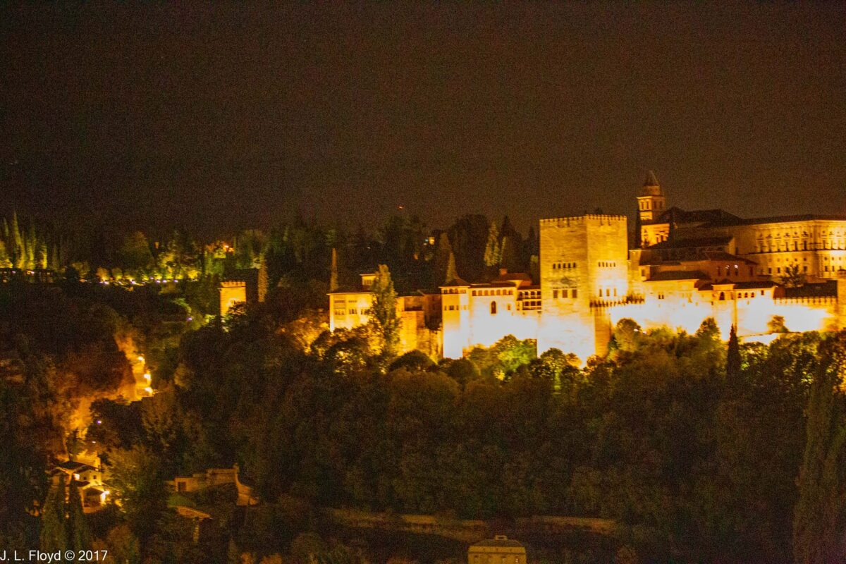
When I was nine years old, my mother gave me a history book with a picture of the Alhambra on one of its pages. I was immediately seduced by the beauty of the place; ever since then it was at the top of all the places in the world I wanted to visit. On November 9, 2017, I was finally able to turn that hope to reality.

I was exceptionally fortunate in being able to enjoy the experience in company not only with my wife Sandie, but also my treasured lifelong friends Chuck and Elouise Mattox, who had invited me to join them on the tour in the first place.

At this point it is appropriate to provide a bit of background about the Alhambra. The Emirate of Granada, the last independent Muslim state in Western Europe, was founded in 1232 by Muhammad Ibn Yusuf Ibn Nasr, later known as Muhammad I Ibn al-Amar. This was a time when the Muslim dominion in Spain, established by conquest in 712 CE, was in terminal decline. The Christian armies were on the march, taking Córdoba in 1236 and Seville in 1248. Yet the polity founded by Muhammad I Ibn al-Amar managed to hang on for over two centuries – though it did so as a vassal of Castile – until the rulers of a united Christian Spain decided to put an end to it. During the limited period of its existence the Emirate of Granada was able to enjoy considerable prosperity, for a limited time, and to generate the last great cultural flowering of Moorish Spain.

Muhammad I had already settled in Granada by 1328 and began the construction of the Alhambra in that year. His successors continued to expand and enhance it. The dynasty he founded is known as the Nasrids.

On January 2, 1492, Ferdinand of Aragon and Isabella of Castile accepted the surrender of the last Emir of Granada, Muhammad XII, also known as Boabdil, and made their triumphal entry into the Alhambra. Although the terms of the surrender guaranteed that the Muslims would be allowed to continue practicing their religion, the Catholic monarchs, under the influence of the Archbishop of Toledo and Chancellor of Castile, Francisco Jiménez de Cisneros, reneged on their promise. Cisneros conducted a mass forced conversion, burning their books and suppressing their ensuing revolt; in 1500 he declared that there were no more Muslims in Granada. But the Moriscos, as the unwilling converts were called, continued practicing their religion sub rosa, and in 1609, after suppressing several more rebellions, the government of Philip III issued a decree expelling all the remaining Moriscos from Spain.

After taking possession of the Alhambra, the Spanish monarchs used it as a royal residence and made a number of alterations – both additions and demolitions – to it. The most important of the additions was the Palace of Charles V, begun in 1527. But later, in the 17th and 18th centuries, the Alhambra ceased to be a focus of attention and it was severely neglected. During the Napoleonic Wars, the French occupied Granada, and when they were finally driven out, they attempted to blow up the Alhambra, and actually succeeded in destroying parts of it before being foiled by a heroic Spanish soldier, José Garcia, who disabled the fuses on the charges and thereby saved the rest of the fortress. In the 19th century there was a revival of interest in the Alhambra, and efforts to preserve and restore it were undertaken and have been continued over the years since.

Although our tour bus dropped us off close to the walls of the Alhambra, it was still a fairly long walk from the parking area to the entry point at the Puerta de las Justicias – the Justice Gate. It was nevertheless a very pleasant walk along a shady tree-lined avenue, the Paseo Bosque de la Alhambra, and it took us past the Hotel Washington Irving, named after the American author (famous for the short stories “Rip van Winkle” and “The Legend of Sleepy Hollow”) who spent several months living in the Alhambra in 1829 and wrote Tales of the Alhambra in the aftermath of his stay. Irving was one of the people most responsible for stimulating public interest in the Alhambra and for sparking efforts to preserve and restore it.

The Puerta de las Justicias was known as the Bab al-Shari’a, Gate of the Law, in Arabic. It was built in 1348, during the reign of Emir Yusuf I, and provides entry first through a large horseshoe arch, above which is a carving of an upraised human hand. This symbolizes the Five Pillars of Islam, which are the Muslim creed (“No God but God, and Mohammed is His Prophet”), praying to Mecca five times a day, charity to the poor, fasting in the holy month of Ramadan, and the pilgrimage to Mecca. I had seen the same symbol at the Alhambra Gate in the Pena Palace in Sintra, Portugal, earlier in the trip; as the name implies, it was copied from the Alhambra.

After passing under the arch, one climbs up a steep ramp and then makes a couple of turns through successive right-angled passageways to enter the fortress. The passageways were designed so that defenders of the fortress could shower arrows and boiling oil on any attackers trying to enter through this route. On the inner side of the Justice Gate is a carving of a key, another symbol of the Islamic faith.

Having passed through the Justice Gate, we found ourselves in a courtyard facing the Palace of Charles V. After succeeding to the thrones of Castile and Aragon as Carlos I in 1516, Charles was elected Holy Roman Emperor in 1519. (Charles is the French and English form of his name. In Spanish he is Carlos, and in German Karl.) He visited Granada in 1526 with his wife, Isabella of Portugal, and decided to make the Alhambra one of his royal residences. He had some of the former Nasrid palaces demolished to make way for a huge new Renaissance-style palace of his own, which was begun in 1527. However, it was not finished during Charles’ lifetime. Charles V spent most of his reign crisscrossing his domains, which included not only Spain but also the Netherlands, parts of Italy and, of course, Austria and Germany, fighting wars against France and the Ottoman Turks, and trying to suppress the Protestant Reformation. He rarely stayed in one place for long. His son and successor as King of Spain, Philip II, was different; he seldom left Spain, but he made his capital permanently at Madrid and did not reside at the Alhambra. Instead he lavished his attention – and his finances – on building his own palace-cum-monastery, the Escorial, near Madrid. Construction of the Palace of Charles V consequently dragged on and was frequently interrupted due to financial exigencies and rebellions, such as the Morisco Rebellion in Granada in 1568. Work on the palace ceased altogether in 1637, at which time not even the roof had been finished. Over the following three centuries, it was at times used as a storehouse and a barracks (e.g. by the French during the Napoleonic Wars), and in general left to deteriorate. However, in the 20th century interest in restoring and finishing it revived, and the roof was eventually completed – in 1967. Nowadays the Palace houses a museum.

The architecture of the Palace of Charles V is rather idiosyncratic. It is square in form, but with an inner circular courtyard, a feature unique for its time. It has two stories; the ground floor is in the Tuscan order, with plain unfluted Doric columns and a simple entablature, while the upper floor is in the more elaborate Ionic order. The inner court repeats the pattern, but with a Doric colonnade made of conglomerate stone and surmounted by an elaborate classical entablature.

Exiting the courtyard of the Charles V Palace, we found ourselves in the Plaza de los Aljibes, looking west toward the Alcazaba, the oldest part of the Alhambra. There were fortifications there long before Muhammad I Ibn al-Amar founded the Alhambra, but he greatly expanded and strengthened them to create the Alcazaba, which then became the citadel or keep of the Alhambra. We did not enter the Alcazaba; although its towers have been restored, the area within its walls contains mostly excavated ruins of houses and other structures used by the soldiers who guarded the citadel in days of yore. Instead we turned east to explore the chief glory of the Alhambra, the Nasrid palaces.

We entered the oldest and westernmost of the Nasrid palaces, the Mexuar, through two successive courtyards, the first being the Patio de la Mezquita, so named because it used to be the site of a small mosque, along with a series of secretarial offices. Only the foundations of these structures remain now. Passing through a high cypress hedge, we then entered a second courtyard, the Patio de la Machuca, named after an architect who resided there in the 16th century while working on the Palace of Charles V. In Nasrid times it was surrounded on the north, south and west sides by a portico, but nowadays only the north portico remains, the south and west components having been replaced by the cypress hedges. In the center of the patio is a rectangular pool with six semi-circular extensions on the sides; it formerly held a fountain featuring two lion statues, but these too have vanished. The east side of the Machuca is occupied by the Mexuar Palace itself. One enters it on the south side through a passageway paved with beautiful floral mosaics.

Upon entering the palace, we found ourselves in its main room, the Sala del Mexuar, or Council Room as it was known in Nasrid times, when it served as a throne room and audience chamber for the emir. After the Christian conquest it was converted into a chapel. Regrettably I was unable to obtain any decent photos of the entire hall, but there are some nice ones available on Wikipedia. The walls of the Sala del Mexuar are sumptuously decorated with carved stucco panels and tilework skirting, and in the center of the chamber stand four marble columns enclosing a space formerly reserved for the throne of the emir. The columns uphold a wooden ceiling with capitals and consoles (bracket-like support structures) featuring elaborate muqarnas (honeycomb-vault adornments). The capitals of the columns retain their original polychrome decoration. This central space was originally covered by a dome, but that was removed in the 16th century to make way for a new upper chamber to be built over the Sala del Mexuar; it was replaced by a wooden ceiling, which however preserves the geometric designs characteristic of Muslim architecture.

And speaking of geometric designs, mosaic tilework (known in Arabic as zellij) is ubiquitous throughout the Nasrid palaces, not excepting the Mexuar; it is found mostly in the form of tile skirting on the lower walls. The Christian rulers continued to use Moorish artists to work in the Alhambra after the 1492 conquest, and on one of the walls of the Sala del Mexuar is a tile mosaic with the words “Plus Ultra” (Further Beyond), the motto of King Carlos I/Emperor Charles V, who ruled Spain from 1519 to 1556. The words allude to the Latin saying “Ne plus ultra” which was for many centuries a warning to sailors to go no further beyond the Pillars of Hercules marking the Straits of Gibraltar, for there lay the vast unknown waters of the Atlantic Ocean, the mysterious, unknown edge of the world, where fearsome dangers awaited those who ventured thither. The Spanish explorers had dared to do so, and their daring had secured vast new territories, with limitless riches for the country and its monarchy. Also appearing in the some of the tile mosaics is the motto of the Nasrids, “And there is no victor but God”.

Adjoining the Sala del Mexuar is a small room which served as an oratory, or private prayer room for the ruler. It contains a mihrab (prayer niche) and features elaborate carved stucco decorations covering the walls. The multiple double-arched windows provide superb views of the landscape and the city of Granada below the walls of the Alhambra.

After passing through the Oratory, we arrived at the final chamber of the Mexuar Palace, the Cuarto Dorado, or Gilded Room. This is a relatively small space, which in the Nasrid era was used as a waiting room for people queuing for audiences with the emir, but after the Christian conquest was adapted for residential purposes. This remodeling included the creation of a gorgeous ceiling decorated in gold leaf, hence the gold in “Cuarto Dorado.” However, even more spectacular than the chamber itself is its adjoining courtyard, the Patio del Cuarto Dorado, which provides a transitional space to the Comares Palace. The north side of the patio features a fine three-arched portico providing access to the Gilded Room; the capitals of the supporting columns are decorated with elaborate stucco carvings in a style favored by the Almohads, the predecessors of the Nasrids. In the middle of the courtyard is a simple but elegant scalloped stone basin.

On the opposite (south) side of the Patio de Cuarto Dorado is the imposing façade of the Comares Palace. This was erected in 1370 by Emir Muhammad V to celebrate his conquest of the important city of Algeciras, the key to the control of the Strait of Gibraltar. It has two identical doors, framed in colorful zellij tiles, the one on the left leading to the Comares Palace, the other connecting back to the Mexuar. Except for tile skirting at the bottom, and three windows on the second floor, the façade wall is decorated entirely with stucco, carved with elaborate designs and inscriptions in Arabic calligraphy, such as verses from the Koran.

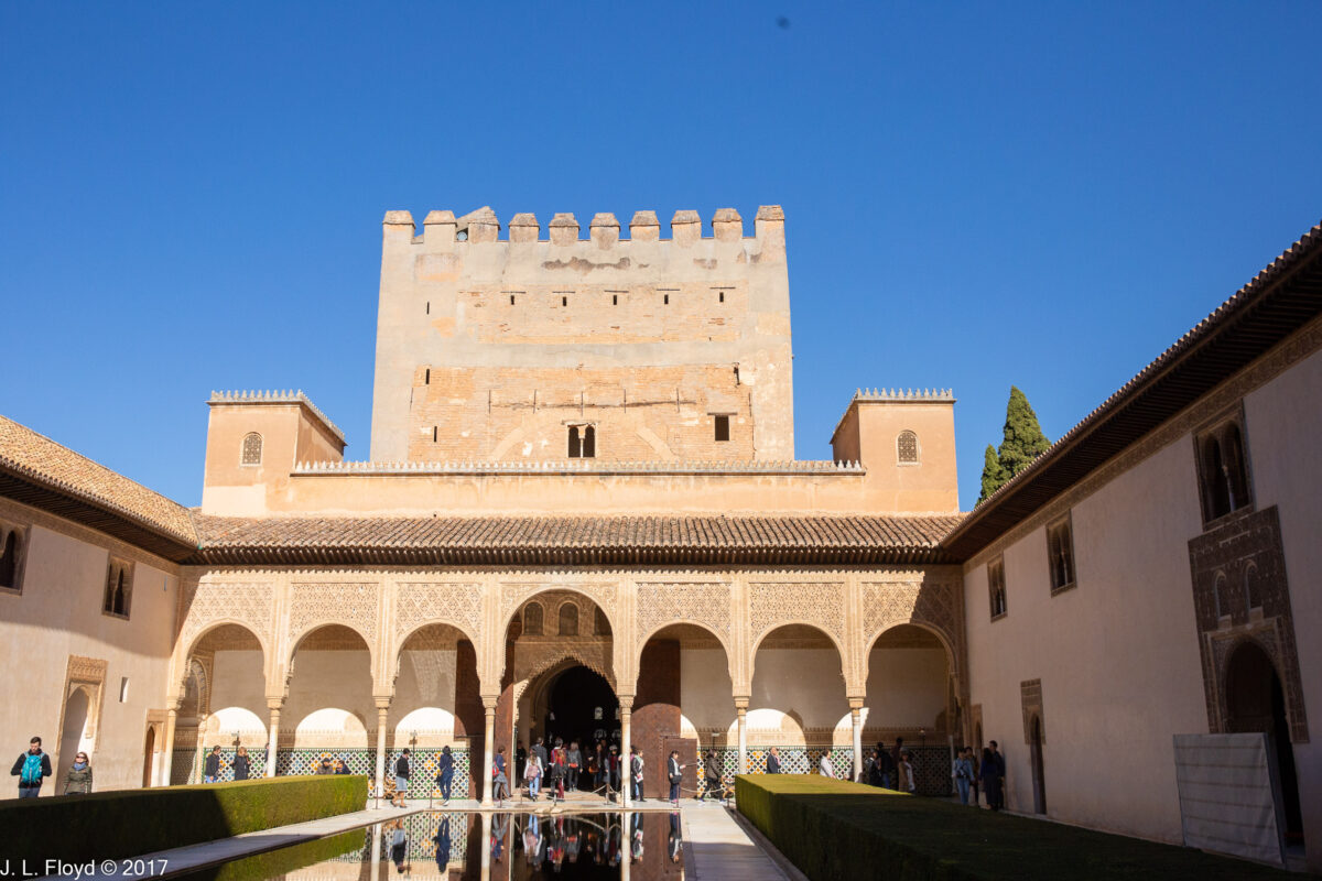
Entering the door on the left, we threaded our way through a narrow passageway, from which we emerged to find ourselves in the Court of the Myrtles, the iconic central element of the Comares Palace.

The Comares Palace was begun in the reign of Isma’il I (r. 1314-1333), expanded by his successor Yusuf I (r. 1333-1354) and completed under Muhammad V (r. 1354–1359 and 1362–1391), though of course it was further modified by the Christian conquerors after 1492.

The Court of the Myrtles is a rectangular space 36 meters (121 feet ) long by 23 meters (75 feet) wide, with the long side oriented along a north-south axis. In the middle is a pool, also rectangular, 34 metres (112 feet) long and 10 meters (33 feet) wide. Water flows into the pool from two circular basins at either end; their design was cunningly calculated to make the water flow so slowly that it does not make ripples in the pool, the surface of which remains so still that the pool is perfectly reflective, as illustrated by the accompanying gallery photos. Myrtle hedges running along the the east and west sides of the pool give the courtyard its name.

The Comares Palace is built around the courtyard, with multistory pavilions at both north and south ends, connected by two-story structures on the long sides. In front of each pavilion is a portico with a wide central arch flanked by three arches on each side. The arches are lavishly decorated with designs in stucco, and the galleries behind them are resplendent with zellij tile skirting and muqarnas vaulting. The lateral structures on the long sides are austere by comparison, with a few widely-spaced windows and doors decorated with stucco framing. The doors lead either to residential quarters or to passages connecting with the Cuarto Dorado, the Comares Baths, and the Palace of the Lions.

The north pavilion is the heart of the Comares Palace, consisting of the Sala de la Barca and the Comares Tower with its vast Hall of Ambassadors, also known as the Throne Room.

The south pavilion was originally built as residential quarters for the royal family, but it was mostly demolished in the 16th century to make way for the Palace of Charles V, leaving nothing but the façade, which is nevertheless quite imposing. It consists of three levels. At ground level there is a portico and gallery similar to those at the north end. The second level has seven windows with wooden latticework performing the same function as venetian blinds in other cultures. The third and top level features a lavishly decorated gallery with seven arches and a large central doorway.

The Northern Pavilion is entered via the Sala de la Barca. The name, meaning “Room of the Ship,” does not seem to be associated with any nautical motif but is thought to be derived from the Arabic word baraka, meaning “blessing,” which is found on inscriptions in the room. (The resemblance to the given name of an American president is duly noted.) It is believed to have served as a waiting room for persons seeking audience with the emir. The hall has an ornate wooden ceiling decorated with elaborate geometric figures; it was destroyed by a fire in 1890 but later rebuilt with the aid of surviving fragments.

Upon entering the Throne Room, or Hall of Ambassadors as it is also known, one is immediately overwhelmed by its vastness. It is the largest room in the Alhambra, 18.2 meters (60 feet) high and 11.3 meters (37 feet) on each side. The ceiling, composed of 8017 pieces of wood fitted together to form a complex geometrical pattern, is 125 square meters (1346 square feet) in area. Floor space is 127.7 meters (1375 square feet). The central part of the floor is paved with lusterware tiles, so called because they are made with a metallic glaze that produces an iridescent effect.

Like most of the chambers in the Nasrid palaces, the Throne Room’s upper walls are smothered in detailed stucco decoration, while the lower walls are covered with zellij tiles displaying various brightly colored geometric designs. At the top of the walls are windows with lattice grilles. At ground level, three of the walls have three alcoves each, with lattice-grille windows; in each case the center alcove is larger, with double windows, and the central alcove on the north wall, facing the muqarna-festooned entrance archway, is the most elaborately decorated, since the throne of the emir was located there.

The baths of the Comares Palace, located on the east side of the Court of the Myrtles, are said to be the best-preserved medieval Muslim baths in the Iberian peninsula, and judging from the photographs I have seen of them, are quite attractive. However, in order to keep them that way, they are closed to tourists. So next on our itinerary was the Palace of the Lions, also on the east side of the Court of the Myrtles, next to of the baths.

Like the Comares Palace, the Palace of the Lions is built around a central courtyard. Rather than a pool, however, the centerpiece is a fountain surrounded by twelve stone lions. Also, in contrast to the Court of the Myrtles, the Corte de los Leones – measuring 28.7 meters (94 feet) long by 15.6 meters (51 feet) wide – has its long axis oriented east-west rather than north-south.

The Palace of the Lions was built during the reign of Muhammad V, between 1362 and 1390, when Nasrid architecture is considered to have reached its high-water mark. The archetypal feature of this period was the extensive use of muqarnas – stalactite-like honeycomb vaulting – or mocárabes, as they are known in Spanish – and it was precisely here, in the Palace of the Lions, that they attained their supreme expression.

The Court of the Lions is surrounded on all sides by a portico supported by arches and columns arranged in a pattern that alternates single columns with two pairs of double columns, with the purpose of highlighting various parts of the façade. Two pavilions, one on the east side of the courtyard and another on the west, extend outward from the portico, supported by slender columns in an arrangement similar to the portico. The arcades of both portico and pavilions are decorated with elaborately carved or molded stucco designs. The design on the capital of each column is unique to that column.

Behind the portico are the four main halls of the Palace of the Lions: the Sala de los Mocárabes (Hall of the Muqarnas) on the west, the Sala de los Abencerrajes (Hall of the Abencerrajes) on the south, the Sala de los Reyes (Hall of the Kings) on the north, and the Sala de Dos Hermanas (Hall of Two Sisters) on the north. It should be noted that most if not all of the names of the Nasrid palaces and their components were conjured up by the Spaniards after the 1492 takeover; the pre-Conquest Arabic names are mostly forgotten.

The central element of the palace, the Fountain of the Lions, consists of a large basin sitting on the backs of twelve stylized marble lions (each one unique, a little different from the others) streaming water into an encircling moat through spouts in their mouths. As with the pool in the Court of the Myrtles, the Fountain of the Lions displays the highly sophisticated Nasrid knowledge of hydraulic engineering. Water was maintained at a constant level in the basin at all times. The water spewed by the marble lions flows from the moat into four gutters, representing the four rivers of Paradise (Euphrates, Nile, Sihran and Jihran) in Islamic (and Christian) lore, which then flow to round basins with fountains in each of the four main halls. Apparently lacking pumps of any kind, not to mention electric power, the system relied entirely on gravity to maintain and regulate the water flow. To my mind this was a rather impressive achievement for its time.

We explored each of the main halls of the Palace of the Lions in turn, starting with the Sala de los Mocárabes. However, we spent little time there, because in 1590 an explosion in a gunpowder magazine (why was that there?) destroyed it and it has never been reconstructed, except for part of the ceiling. We soon found ourselves in the Sala de los Abencerrajes, which was named after a powerful family of the Emirate of Granada. Known in Arabic as the Banu Sarraj, they played a prominent role in the politics of the kingdom, but according to legend they aroused the ire of the Emir and were all massacred in the hall that bears their name. As far as can be determined the legend has no basis in fact, and the name of the hall in Arabic translates to “the Western Dome.” It does indeed have a dome, with a cupola shaped like an eight-pointed star, so that it has 16 sides and the same number of windows, one on each side. The dome and the ceiling around it are lavishly decorated with complex muqarnas. Intricate stucco decoration covers the upper walls, and colorful zellij tiles skirt the lower walls. The total effect is astounding, a sybaritic feast for the eyes, as well as a preview of what we were to see in the other two halls of the Lion Palace, in their distinct variations.

Circling around the Corte de los Leones counterclockwise, we next visited the Sala de los Reyes, on the east side of the courtyard. This is a long and wide hall, running the entire length of the east side of the Corte, but it is divided into seven sub-halls – three large and square, four smaller and rectangular – by muqarnas arches. The small and large spaces alternate in their order, so that there are two smaller spaces between the three larger ones and one small unit on each end. Each unit, small or large, has its own muqarnas-vaulted ceiling. The three larger chambers have rounded vault ceilings made of wooden planks but covered with leather painted with scenes of court life. These represent a motif fairly uncommon in Muslim art, because of the traditional Islamic strictures against depicting human and animal figures. It is thought that they were most likely executed by Christian artists borrowed from the court of Mohammed V’s contemporary Pedro the Cruel of Castile – who, it should be remembered, built the Alcazar in Seville with the help of Muslim craftsmen from Granada. Perhaps there was some sort of cultural exchange going on there. One of the paintings depicts the Emir in council with some of his officials; it is this that gives rise to the name of the hall, which, to risk belaboring the point, is a Christian rather than a Nasrid appellation. Conditions in the hall prevented me from obtaining legible photos of these paintings, but there are examples available on the web from Wikipedia and other sources.

In Nasrid times, the Hall of the Kings was a place for celebrations and feasts, with the smaller units serving as bedchambers. After the 1492 conquest, it was used as a Christian chapel. Ferdinand and Isabella held their first celebratory Mass there after the surrender of the Alhambra.

The Sala de Dos Hermanas, which was next on our itinerary, has traditionally been thought of as a private residential space for Mohammed V and his family, although some scholars think that it might have been used as a meeting place for the Royal Council. The sisters for whom it is named are not members of the royal family but rather two slabs of marble used to pave the floor. The Nasrid/Arabic name for it was al-Qubba al-Kubrā (“the Great Dome”), possibly likening the muqarnas dome over the hall to the vault of the heavens. And indeed that dome is reminiscent of a starry cosmos. The muqarnas vaulting, composed of over 500 prismatic pieces, seems to radiate outward from the top in concentric waves before flowing around 16 miniature domes at the periphery, where their spicules merge into a surrounding web of muqarnas. The ensemble is enclosed within a cupola 8 meters in diameter, with eight sides, with two windows to each side, their combined illumination causing the honeycomb structure of the muqarnas to sparkle with reflected light. The ceiling around the cupola opening is sculpted with muqarnas contrived to form the shape of an eight-pointed star, standing out from the background of additional honeycomb vaulting filling the spaces between the ceiling and the walls.

The upper walls, as in most of the other halls of the Nasrid palaces, are covered with intricately carved stucco. Encircling the room, approximately at eye level, is an inscription band with poetry comparing the hall’s dome to the Pleiades. On the lower walls, again in conformity with the usual practice, are elegant zellij tiles – but here they are the originals, not replacements from later periods as in some of the other halls.

Adjoining the Sala de Dos Hermanas on the north is a smaller chamber, the Sala de los Ajimeces or “Hall of the Mullioned Windows” – a mullion being a vertical or horizontal bar, vertical in this case, that separates units of a window (I had to look that up). Its distinctive feature, other than the windows, is a vault ceiling composed of multiple consecutive muqarnas domes merging into one another. On its north side is a much smaller but more striking room, the Mirador de Lindaraja. In Spanish a mirador is a lookout or scenic viewpoint. “Lindaraja” is a corruption of the Arabic phrase Ayn Dar Aixa, “Eyes of the House of Aisha”, referring to a tradition that the room was the preferred hangout of Muhammad V’s favorite wife, Aisha. The Mirador de Lindaraja is a small square structure projecting outward from the Sala de los Ajimeces into the garden outside the palace. The windows on the three sides of the room are installed low enough so that the garden is visible to people sitting on the floor. Indeed the garden, known as the Patio de Lindaraja, is worth a look, and we were to explore it in person a bit later. The Mirador arguably boasts the most elegant carved stucco paneling in the Alhambra, not to mention the mosaic tilework on the lower walls, featuring poetic inscriptions in fine Arabic calligraphy. It is also remarkable for its ceiling, which is a wooden lattice framework embedded with pieces of stained glass – a type of skylight, in other words, also known as a lantern vault. It is the only one of its kind surviving in the Alhambra.

In my travels I have seen some amazing sights, including some of the most magnificent works of art produced by human hands; but in my judgment none of them surpass the Nasrid palaces of the Alhambra, and I consider it a great privilege and gift to have seen them in person.

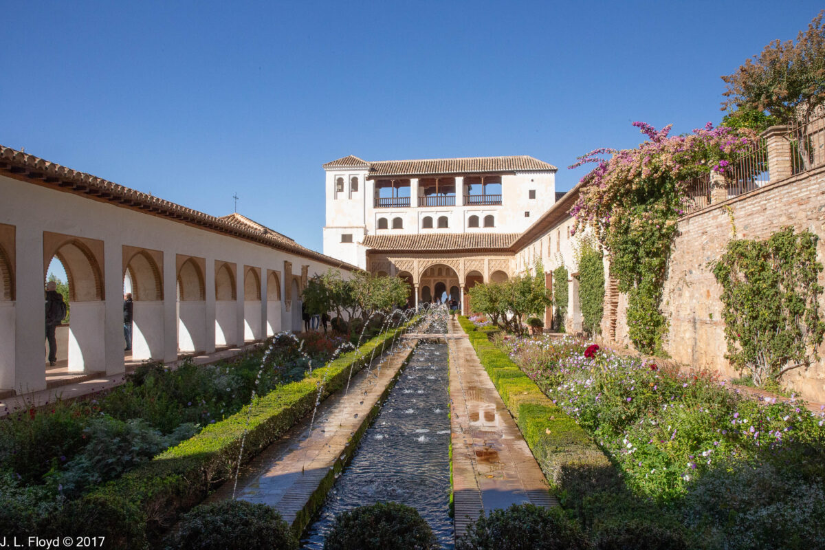
At this point in our tour, we were not done with the palaces, but the remaining ones were dispersed amidst the gardens of the Alhambra, which will be the focus of my next post.

Categories
Danube River Cruise, June 2023

Prague – Charles Bridge and Old Town, June 25, 2023

At the end of our Sunday morning tour of Mala Strana we arrived at the Charles Bridge, which spans the Vltava River from Mala Strana to the Old Town of Prague.

While writing this post, I learned that my lifelong friend Charles (Chuck) Mattox had passed away in Bend, Oregon. I had known Chuck for over 60 years, since we met in 1960 while we were both at Long Beach State College (now California State University at Long Beach). After graduating from college and serving in the army, he had moved to Oregon for graduate study at the University of Oregon in Eugene, where he met Elouise Foiles; they were married in 1965, and I served as best man at their wedding. Since then we had remained in touch. I visited them in Bend whenever I could, and after Sandie and I were married in 2002, we had taken several fabulous trips along with Chuck and Elouise to view solar eclipses. A few years before, Chuck and Elouise had taken a Danube cruise very much like ours, and Chuck had stood on the Charles Bridge, just as I did on the morning of June 25, 2023. This post is dedicated to his memory.

In my last post I mentioned the Judith Bridge, which was built in 1172 and which was protected by a chain associated with the Church of Our Lady under the Chain; in 1342 that bridge was wrecked by a flood, and construction on a new bridge began in 1357, in the reign of Charles IV. The new bridge was called the Stone Bridge at first, but since 1870 it has been known as the Charles Bridge. Instead of a chain, the bridge was protected by towers, two on the Mala Strana side and one on the Old Town side. It was completed in 1402.

The Charles Bridge is 516 meters (1,693 feet) long and nearly 10 metres (33 feet) wide. Thirty sculptures line its sides, replicas of originals mostly erected from the late 17th through the 19th centuries. I tried to photograph them all; I did not succeed and got lost in the process, but I did shoot most of them. I won’t try the patience of the reader by presenting all of those I did shoot on this page, but I will show a few of the best.

It was a sunny (and hot) Sunday in June, and as one might expect, the bridge was packed with tourists like us. It was hard to get an unobstructed picture of anything, but I did my best.

In fact, I became so absorbed in taking pictures that by the time I came to the Old Town end of the bridge, I had lost touch with my tour group. I looked around for a few minutes and when I didn’t see any of them, I thought they must have left me behind. I didn’t know which way they had gone, so I just went straight ahead on Karlova (Charles) Street, which comes off the bridge. After a few blocks I hadn’t found them, so I turned back and returned to the bridge tower. It turned out that they were all there, looking for me.

So again I set off, this time together with the tour group, down Karlova Street through the Old Town of Prague. First we had to pass through Crusader Square (Křižovnické náměstí), so named because the monastery of the crusading order of the Knightly Order of the Crusaders with the Red Star, along with its associated Baroque church of St. Francis of Assisi, borders the north side of the square. Another Baroque church, that of St. Salvator, stands on the east side of the square, and on the south side is the historic and imposing Colloredo-Mansfeld Palace, formerly a residence for aristocratic families. In the middle of the square is a neo-Gothic monument to King and Emperor Charles IV, unveiled in 1851.

Karlova Street proved to be a touristy shopping district, not as high-end and snooty as Paris Street, which we had seen the day before, but more lively and affordable.

At 4 Karlova Street we passed a house where the astronomer Johannes Kepler lived from 1607 to 1612, while he was Court Astronomer to Emperor Rudolf II.

Karlova Street is full of inviting boutiques, cafes, pubs and other establishments, too numerous to catalogue. Again I could not help but marvel at how American-oriented (or Anglo-oriented, same difference) Prague has become. Many of the names and signs on the shops were in English: there was the Mad Rabbit ice-creamery, the Golden Crown jeweler, a Local Artists gallery, the Duck Boutique and my favorite, the Fat Cat pub, which had a sign (in English) advertising “Husband Day Care”.

Karlova Street twists and winds tortuously for several blocks through the heart of Old Town Prague before ending at Malé náměstí, “Little Square,” which is an adjunct to Old Town Square to its east.

Thus it was that at the end of our walking tour of Mala Strana, our Gate1 group ended up in Old Town Square, the same place where we had finished the previous day’s tour. So I had another chance to shoot some scenes in this amazing place, of which I couldn’t get enough, and I experienced a somewhat different perspective of it than on the first day. Most notably, on Sunday there was a major demonstration against the Chinese Communist Party, with placards reading “Chinese Communism is evil!”, “NO to Chinese gulags!” and “400 million Chinese quit the Communist Party!” I doubt whether the demonstrators caused much dismay for Xi Jin-ping, but I was impressed by their fervor.

Our Gate1 tour group disbanded in Old Town Square, and we were free to go our separate ways; I took the option of walking back to the Cosmopolitan Hotel to rest up and get ready for the final adventure of our visit to Prague, which was in store for Sunday afternoon.

Categories
Danube River Cruise, June 2023

A Sunday Afternoon Motor Tour of Prague, June 25, 2023

Sandie felt poorly the entire time we were in Prague and was mostly confined to our hotel room, unable to manage the excursions, which involved a lot of walking. So for our final afternoon, I arranged for us to be taken on a two-hour motor tour. It was a bit pricey at 250 euros, but it was the only way Sandie would be able to see a bit of Prague, and I didn’t want her to miss out completely on one of the grandest and most memorable cities I’ve ever seen.

The tour outfit I booked with uses replicars for their excursions. These are replicas of vintage Mercedes-Benz, Alfa-Romeo and other classic automobiles that look like exact duplicates of the originals, but are equipped with modern engines and drive trains. Our vehicle turned out to be a copy of a 1947 Alfa-Romeo. It was completely open to the sky and the weather was sunny and warm. The driver (sadly, I’ve forgotten his name) was a jovial twenty-something fellow who spoke fluent idiomatic English (it seems that nearly everyone speaks English in Prague) and knew the city well. He appeared to have a standard itinerary but was also quite flexible and willing to entertain special requests about places to visit. He took us to some attractions that I had already seen, but Sandie hadn’t, and I wanted her to see them; but he also took us to places I hadn’t yet been on the Gate1 walking tours, which made for a rich experience for us both.

Our driver picked us up at our hotel and drove up Na Poříčí Street to Republic Square. I had seen plenty of Republic Square already, since it was near our hotel, but I was able to appreciate its sights better with the help of the driver’s comments, and we were able to add some new photos to those I had taken already.

Republic Square is the site of a number of significant attractions. The most prominent is the Powder Tower (Prašná brána), which was actually one of the original city gates of the Old Town. Its construction began in 1475, in the reign of Vladislav II (r. 1471-1516). At that time it was called simply the New Tower. In the 17th century it was used to store gunpowder, hence the current name. Coronation processions for Czech kings traditionally began at the Powder Tower and ended at Prague Castle.

Also on Republic Square is the Palladium Department Store, actually a huge indoor shopping mall, which I had explored a bit the day before. Prior to the 1990s it had been the Josef Army Barracks building. It was repurposed, rebuilt and opened as a shopping mall in 2007, and now contains 170 shops and 30 restaurants, as well as a considerable amount of office space.

Unfortunately, I unaccountably failed to notice that the Kotva Department Store, one of the examples of Brutalist architecture modeled in Holubička Park, which I had seen in Malá Strana earlier that day, is located across the street from the Palladium, so I don’t have a photo of the actual building, only the model in Holubička Park. I did get a photo of the headquarters of the Czech National Bank (Česká národní banka, abbreviated ČNB), also found on Republic Square.

Next to the Powder Tower, just to its north, stands Municipal House (Obecní dům), a splendid structure built in the Art Nouveau style in the early 20th century. It occupies the site of a vanished royal palace, where the Kings of Bohemia lived until 1485, when they moved to the Prague Castle. It was the site of the Czech Declaration of Independence in 1918. The building houses Smetana Hall, a major concert venue, as well as a ballroom, civic facilities, a café and a French restaurant. It is also adorned both inside and outside with outstanding artworks, including a mosaic called Homage to Prague over the entrance and allegorical sculpture groups on either side. Unfortunately our photos don’t do justice to these, so I’ll refer the reader to the pictures on the Municipal House website.

Prague is a veritable treasure-house of Art Nouveau, which was a great pleasure for me since it’s one of my favorite styles. From Republic Square we drove to Wenceslaus Square, and on the way we passed the Prague Main Railway Station, first built in 1871 in the Neo-Renaissance style bearing the name of Emperor Franz Josef. By the end of the 19th century it was sorely in need of expansion, so it was rebuilt in 1901-1909 in Art Nouveau style according to a design by architect Josef Fanta, and extensively decorated with statues and other works featuring Art Nouveau motifs.

Wenceslaus Square (Václavské náměstí) is named after Václav I (907-935), the patron saint of Bohemia and the subject of the Christmas Carol “Good King Wenceslaus.” He was Duke of Bohemia (which did not officially become a kingdom until 1198) from 921 to 935, and was later canonized for his good works and his martyrdom at the hands of his brother Boleslav in 935. I don’t know how the Czech name Václav became Latinized to Wenceslaus, which sounds ridiculous to me, but the square was established in 1348, during the reign of Charles IV, as a market for trading horses, so its original name was the Horse Market. It was renamed St. Wenceslaus Square in 1848. It is a very large square, 750 meters (2460 feet) long by up to 63 meters (207 feet) wide, and has been the scene of a number of key events in Czech history, most notably demonstrations against the Soviet invasion of 1968 and the inception of the Velvet Revolution of 1989.

Near Wenceslaus Square, though not actually on it, is the Prague State Opera House, originally opened in 1888 as the New German Theater, created in response to a desire for the German community in Prague for a theater of its own. Since 1992 it has been part of the National Theater of the Czech Republic, in association with the other main Prague opera house, the National Theater (Národní divadlo) located on the east bank of the Vltava River. With its magnificent auditorium and elaborate neo-rococo décor, it is considered one of the great opera houses of the world.

At the east end of Wenceslaus Square is the main building of the Czech National Museum. Established in 1818, the Museum was initially located in the palace of its founder, Count Kaspar von Sternberg, but was moved to its present location in 1891, when the building was completed. At first the focus of the museum was on natural sciences, since its founder was a botanist, mineralogist and phytopaleontologist (phytopaleontology is the branch of paleontology concerned with ancient plants). Later, however, in the 1830s and 1840s, the museum began to acquire historical and cultural objects, a reflection of the Romantic movement, which emphasized the importance of historical influences; and it became instrumental in the 19th-century revival of Czech language and culture and the ensuing growth of Czech nationalism.

The main building on Wenceslaus Square was built between 1885 and 1891 by the Czech neo-renaissance architect Josef Schulz. It was damaged by a bomb in World War II, but the collections had been moved to secure locations, so they were not harmed. However, in 1968 when the Soviet troops fired on the demonstrators in Wenceslaus Square, the museum façade was damaged by machine-gun bullets. Although repairs were made, it is said that the marks made by the bullets can still be seen, although I didn’t get close enough to notice any myself.

An equestrian statue of St. Wenceslaus created in 1912 by Josef Václav Myslbek stands in the square in front of the museum’s main building.

From Wenceslaus Square our driver took us to Charles Square, where the New Town Hall (Novoměstská radnice) is located. The oldest part of the building, the eastern wing, was built between 1377 and 1398 in Gothic style. A south wing was added after 1411. The salient feature of the hall, the tower, was built later, between 1452 and 1456. Although it is newer than the Old Town Hall, the New Town Hall was the scene of the First Prague Defenestration in 1419, which initiated the Hussite Wars. In the 16th century, modifications were made in the Renaissance style, and the western and northern wings were added. The New Town Hall served as an administrative center until 1784, when the reforms of Emperor Josef II concentrated all municipal administrative functions in the Old Town Hall. Afterward it housed the main criminal court and a prison.

Charles Square, as one might guess, was founded by Emperor Charles IV, who intended it to be the main square of the New Town of Prague. It was the largest town square of medieval Europe and is still one of the largest city squares in the world. But it was originally called the Cattle Market and was only named after its founder in 1848. The central part of Charles Square has been turned into a park, similar to Central Park in New York.

Not far from Charles Square we drove by the Quadrio shopping mall, where we saw the Head of Franz Kafka. This is a bizarre sculpture by David Cerny, 10.6 meters (35 feet) tall, depicting the head of…someone – I can’t say that I would recognize it as Franz Kafka. Anyway, the head is composed of 42 stainless steel panels which are mechanized and rotate individually, causing the head to deform and reform itself. It’s a controversial but intriguing piece and helps to maintain Prague’s reputation as a center of avant-garde art.

Our next stop was no less contentious — the Dancing House (Tančící dům) on the Rašínovo Embankment near Jiráskovo Bridge. Built on the site of an apartment house destroyed by American bombing in 1945, it was financed by a Dutch insurance company, which bought the land in 1992 and hired the Czech-Croatian architect Vlado Milunić and the Canadian-American architect Frank Gehry to design the building. The architects were given carte blanche, and the result was a structure consisting of two towers, one of glass, the other of concrete. The glass tower narrows in the middle and is supported by curved pillars; the concrete tower is straight, but features wavy moldings and out-of-alignment windows. The towers have been nicknamed Ginger and Fred, after the American dancers Ginger Rogers and Fred Astaire – Ginger represented by the glass tower and Fred by the concrete tower. The Czech-British architect Eva Jiřičná designed most of the interior of the building, which has has nine floors, with two underground. The building contains a hotel, an art gallery and a restaurant, named “Ginger and Fred,” of course. Although the Dancing House has won several awards, including a Time Magazine design prize in 1997, it has been heavily criticized as being inappropriate and outlandish in a city where most of the architecture is Gothic, Baroque, or Art Nouveau.

Next we crossed Jiráskovo Bridge and headed up to Prague Castle for a brief stop near the Powder Bridge entrance, where our tour bus had brought us the day before. The castle grounds are closed to motor traffic, so Sandie wasn’t able to see all the sights I had seen that morning, but at least she was able to get some idea of the scale and grandeur of the place.

From the Castle we continued on to the top of Petřín Hill, arriving at the colossal Great Strahov Stadium, which claims to be the world’s largest. It was not, as one might expect, a product of the Communist era but was built before World War II with the special purpose of showcasing displays of synchronized swimming. It has a capacity of 250,000, but is no longer used for competitive sports events. Instead it serves as a training ground by the Sparta Prague professional football team, and as a venue for rock concerts.

On the way up to the stadium I spotted and photographed an apparently very decrepit house on the hillside which was plastered with graffiti and looked abandoned. It appeared to have a “Hotel” sign but I’m not sure whether this was actually associated with the house or on another building above it on the hill. I haven’t able to find out any information about it, so I’ve chosen to call it the Strahov Haunted House.

We stopped for a while at Strahov Stadium to take a break, shoot some pictures and stretch our legs. The stadium is poorly maintained and rather decrepit, but the views of Prague from the hilltop are superb. Also it turned out that there is a motor vehicle tunnel running under the stadium, called the Strahov Tunnel, for which ventilation is provided by two immense towers standing next to the stadium. The control room for the tunnel and its towers is also located on the hill nearby. In fact, the hills of Prague appear to be honeycombed with vehicular tunnels and one wonders how they manage to keep the city from caving in on itself.

As we headed back down the hill to our next stop, we spotted a large tractor by the side of the road, upended with its front wheels sticking up in the air, and painted a flamboyant shade of pink. It turned out to be another David Cerny piece, the Monument to Visací Zámek. Visací zámek means padlock in Czech, and indeed one of the front wheels had been fashioned into the shape of a padlock. Visací zámek is the name of a Czech punk rock band founded in 1982, before the fall of Communism; it was highly influential in the opposition movement that led to the fall of the Husak regime in 1989. It has remained active in the years since then, and the monument was erected in 2022 to commemorate its 40th anniversary.

Returning through the Hradčany (Castle) district, we stopped at Loreta Square, where the Loreta Monastery pilgrimage site is located. The monastery was founded in 1626, but the present Baroque building with its imposing clock tower, designed by the famous father-son team of Christoph and Kilian Ignaz Dientzenhofer, dates from the early 18th century. The tower has a famous chime which consists of 30 bells and has been operating since 1695.

Across the square from the monastery we saw the Czernin Palace, largest of the Baroque palaces of Prague, built in the 1660s for the wealthy aristocrat Humprecht Jan Czernin, the Habsburg ambassador to Venice and Rome. Since the 1930s it has served as headquarters of the Czech Ministry of Foreign Affairs.

A little farther on, on Loreta Street closer to Hradcany Square, we came across a rather stark Romanesque building painted in kind of a peachy shade of yellow. This was built in the early 18th century as a residence for the ambassador of the Vatican. In the 19th century it served as a military hospital. Nowadays it serves as the barracks of the Prague Castle Guard (Hradní stráž), a special autonomous unit of the military forces whose main task is to guard and defend the seat of the President of the Czech Republic at Prague Castle. I found the site interesting mainly because of the eight-armed cast-iron gas lamppost with sculptural decoration that stands on a stone plinth in front of the building. It was one of sixteen such gas lampposts installed in the mid-19th century. At that time hundreds of less elaborate four-armed, three-armed and one-armed lampposts installed throughout the city, but they went away after the advent of electric lighting; now only three survive, two of them eight-armed and one with four arms. (The other eight-armed lamppost stands in nearby Hradcany Square, but somehow I had missed it when I was there the day before.) The eight-armed models were cast in 1867 or 1868 in the Komárovské ironworks, are 8.5 meters (feet) tall and weigh 5 tons. From the base of the lamppost, on the stone plinth, rises a column surrounded by four female figures in antique clothing; above them the eight baroque arms with lamps radiate out from the column, which rises to a height of several more feet and has an allegorical figure of Prague at the top.  

From the Castle Guard Barracks we drove up to the Military Church of St. John of Nepomuk, another Dientzenhofer masterpiece. It was built in 1729 to serve a convent of the Ursuline Order of Catholic Nuns, but the religious reforms of Joseph II shut the church down in 1784, and it was handed over to the military, which used it as a salt warehouse. But in 1861 it was reopened as a church, serving the military garrison of Prague. In 2002 it was opened to the public. Statues by the Baroque sculptor Matthias Wenzel Jäckel adorn the façade, and the interior is decorated with frescoes by Wenzel Lorenz Reiner illustrating the life of St. John of Nepomuk.

Descending the hill into Malá Strana, we were able to see some of the locations which I had visited there in the morning, as well as a few that were new to me. Sandie had to miss the Wallenstein Palace and Gardens, which are open only to pedestrians, but she was able to enjoy Malá Strana Square with its exquisite St. Nicholas Church, the supreme achievement of the Dientzenhofer father-son architect team. I was able to correct an oversight by photographing the Holy Trinity Column on the west side of the church, which I had missed that morning. It is another example of a pestsäule or plague column, erected in 1715 in gratitude for averting the plague epidemic of 1713. The column is simpler and to my mind more attractive than many of the others I had seen. It sits on a stepped plinth surrounded by a balustrade with putti and vases. On the plinth are statues of the Virgin Mary and several of the Czech saints; above them is a representation of the Trinity, and on top is a three-sided obelisk with a symbol of the Eye of God at the apex.

Of course we dropped by the Knights of Malta Commandery, the Church under the Chain, and the Lennon Wall, so Sandie would have a chance to see them. But one attraction I would never have been aware of had the driver not brought it to my attention was the street known in Czech as the  Vinárna Čertovka, and in English as the Narrowest Street in Prague. This is easy to miss because at first sight it appears to be no more than a tiny space between two buildings. But it is officially a street, though limited of course to pedestrian traffic, and so narrow that it can accommodate only one person at a time, so that traffic lights are needed to control access and ensure that people do not collide with one another.

Not more than a block away from the Narrowest Street we found the Franz Kafka Museum, which I had also not seen earlier. Dedicated to the life and work of the famous writer, it features copies of first editions of Kafka’s works and some of his correspondence. Two permanent exhibitions are focused on exploring the role of Prague in his work, which is enigmatic because he never identified the places he described in his writings, though various locations in the city are unmistakably present in the background. The designers of the museum strove to create a place in keeping with the dark and surreal atmosphere of Kafka’s works, so they created exhibits that are often outlandish and bizarre – sometimes even “goofy,” according to one reviewer – such as open file cabinets, piles of coal, even a torture machine from his Penal Colony story. I must confess that I have never properly appreciated Kafka’s works, having read only one of them, The Metamorphosis, which I was assigned to read in a college history class, and which I found repellent. (Somebody wakes up one morning to find that he has turned into a giant cockroach overnight, and nobody even wonders why?) I also started reading The Trial but found it so dreary and boring that I could not get very far in it. But I regret not having had a chance to tour the museum – we only had time to view it briefly from the street – especially because I missed the famous David Cerny statue in the courtyard of two men peeing into a pool. It is only partially visible in my photograph, and I didn’t notice it at the time I shot the picture. However, you can see a good picture of the sculpture on Wikipedia.

We did manage to see and photograph the surrealist statue of Franz Kafka by Jaroslav Róna which stands in the Jewish Quarter. It depicts Kafka riding on the shoulders of a headless (and handless) figure, an allusion to his short story “Description of a Struggle,” published in 1912.

We concluded our motor tour with drive-bys of some of the other essential Prague landmarks, such as the Rudolfinum concert hall and the National Theater (Národní divadlo) opera house. We also had our driver take pictures of us seated in the Alfa-Romeo on the riverbank near Manes Bridge, with Strakov Academy on the opposite bank of the Vltava as a backdrop.

Although in two days I had managed only to scratch the surface of all there is to see and do in Prague, and I was sad that Sandie didn’t get to see more of the city, I was nevertheless elated that I had finally managed to set foot in a place I had yearned to visit for so many years, a city of endless sights and spectacles and a monument to the immemorial human striving for liberty and enlightenment.