After completing the southern segment of the tour, our bus took us across the Harbor Bridge to North Sydney, where we were able to get some nice views and photos of the Central Business District with its skyscrapers and Sidney Tower, as well as the Opera House and Darling Harbour.
The north shore of Sydney Harbor is more suburban and residential than the south, but no less picturesque. Our tour bus took us to several vantage points from which we were able to obtain fabulous views of the harbor area, while the driver continued to regale us with tales from the history of the city and point out examples of local color.
At one of the stops, Arabanoo Lookout, we learned about Arabanoo, the first Australian aborigine to live among Europeans. In 1788, the first year of the colony’s settlement, relations between the settlers and the aborigines were going very poorly, and Admiral Arthur Philip, the first governor of New South Wales, decided that radical measures needed to be taken to improve communications between them. The means by which he chose to accomplish this was to forcibly kidnap a native and teach him English. Arabanoo, who became the unwilling object of his attentions, was about 30 years old. Phillip’s heavy-handed experiment was not a success; Arabanoo did not learn much English, relations with the aborigines continued to deteriorate, and after six months he died of smallpox, which also spread to the rest of the aborigine population, killing about 2000 of them.
View of Sydney Bay from north Sydney
View of south harbor from north Sydney
Houses and condos on the cliffs of north Sydney
North Head from Arabanoo Lookout
Sydney North Harbour from Balgowlah Heights
North Sydney Harbor area
The ultimate destination of our northern excursion was Manly Beach, on the coast to the north of Sydney Harbor, the place where Arabanoo was taken captive. When first exploring the area, Governor Phillip encountered some indigenous men and commented on their robust and “manly” physique; ever after it was known as Manly Beach.
Manly Beach is one of Australia's most famous beaches, the site of the world's first surfing contest, held in 1964.
Manly Beach had a relaxed ambience that I found quite appealing.
The New Brighton Hotel was easily the most striking structure in Manly Beach.
The name of this pub had a particular appeal to me. I bet Dennis Griesser would have liked it too. Dennis, who passed away in 2022, was an old friend and colleague who had an affinity for frogs.
I found myself right at home in Manly Beach because when I was in college I worked in the Blue Door Cafe in Long Beach, California.
This sleek Italian MV Agusta cafe racing bike on display in a Manly Beach showroom was the first one I had ever seen in person.
We discovered that Australia, like the US and Canada, has its share of outlaw bikers. We would see more of them in South Australia.
At the end of the afternoon, en route back to the barn, our tour bus swung by the Sydney Olympic Park, where I shot a photo of the main stadium.
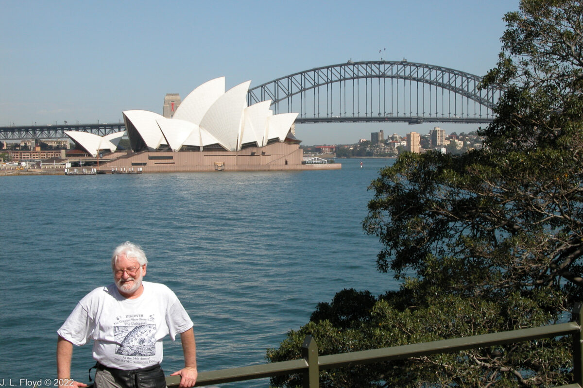
Jerry, with view of east side of Sydney Opera House and Harbour Bridge
On our second day in Sydney we were scheduled to take a morning bus tour of the city and its immediate environs. The bus took us first to the south side of the metropolitan area, then to the north. The driver was a jovial fellow who shared a vast lore of the city and its sights with a generous combination of wit and erudition.
The first half of the tour began at the harbor, and our first stop was Mrs. Macquarie’s Chair. Elizabeth Macquarie was the wife of Major-General Lachlan Macquarie, Governor of New South Wales from 1810 to 1821. According to legend, she liked to sit at the end of a small promontory in Sydney Harbor, just east of Bennelong Point, where the Sidney Opera House now stands, and watch the ships sail by on their way in and out of the harbor. To provide a place for her to sit, convicts carved a large sandstone rock into a bench, now known as Mrs. Macquarie’s Chair; and the promontory is known as Mrs. Macquarie’s Point. It provides excellent views of the Sydney Harbor Bridge and the Opera House, which we used as a backdrop to take photos of ourselves.
Mrs. Macquarie picked her spot well; it also provides great views of the rest of Sydney Harbor.
Fort Denison, which the USS Chicago mistakenly bombarded in World War II, is now a museum.
The inion carved into the rock above the bench on Mrs. Macquarie's Chair - hidden in the shadows in this photo - reads "Be it thus Recorded that the Road Round the inside of the Government Domain Called Mrs. Macquarie's road So named by the Governor on account of her having Originally Planned it Measuring 3 Miles, and 377 Yards Was finally Completed on the 13th Day of June 1816."
Like Mrs. Macquarie, we were able to watch the ships go by on their way in and out of the harbor. A number of them were cruise boats like this one. We would get to go on a harbor cruise ourselves the next day.
Garden Island is the site of the Australian Navy base in Sydney Harbor.
The tall ship on the left is the Royal Australian Navy's latest dreadnought, cleverly disguised as a 19th-century sailing barque; the one on the right is a modern frigate.
The Sacred Heart Monastery stands majestically on a hill high overlooking both Sydney Bay and the Pacific Ocean.
A propos of Fort Denison, the bus driver related a historical episode of particular resonance to me. During the months after Pearl Harbor, when the Japanese conquests in the Southwest Pacific reached their high-water mark, the Japanese Navy sent a submarine force to attack Australia. On May 31, they sent several two-man mini-subs into Sydney Harbor, where in addition to several Australian Navy ships, the U. S. heavy cruiser Chicago was anchored. The captain of the Chicago, Howard Bode, a notorious martinet, was ashore at the time, dining with Rear Admiral Gerard Muirhead-Gould of the Royal Navy, the officer in charge of Sydney Harbor. Neither took the attack seriously at first. One of the midget submarines fired two torpedoes at Chicago and missed. The torpedoes instead hit an Australian barracks ship, the HMAS Kuttabul, which sank with the loss of 21 lives. A Chicago searchlight operator spotted the attacking mini-sub before it fired its torpedoes, and the Chicago fired on the submarine, but it could not depress its guns sufficiently for the close range of the target and the shells missed, hitting Fort Dennison instead, though doing little damage. Bode came back to the Chicago about 23:30; the ship got underway and left port at 2:14 without damage. The significance of this episode to me was that my biological father, Jewell Marion Floyd, was a sailor on board the Chicago during this period. The cruiser had escaped the Pearl Harbor disaster in December 1941 because it was at sea at the time. Later, on August 9, 1942, the Chicago participated in the Battle of Savo Island, and was damaged by a Japanese torpedo. Bode’s judgment in this action – an overwhelming Allied defeat entailing the loss of four heavy cruisers – was called into question; he was relieved of his command and assigned to command the Panama Canal District, a backwater reserved for officers put out to pasture. Feeling himself disgraced, Bode committed suicide on April 19, 1943. The Chicago was repaired and returned to the South Pacific in 1943, under a different captain, where, on January 30, it was sunk by Japanese bombers at the Battle of Rennell Island, taking Jewell Marion Floyd down with it.
After Mrs Macquarie’s Point, our next stop was Federation Cliffs, where we were able to obtain spectacular vistas of the harbor mouth and the Pacific Ocean beyond.
Disembarking from our bus at Federation Cliffs, we found ourselves on a narrow peninsula leading to South Head at the entrance to Sydney Harbor.
From the park on the peninsula we had a view both of the ocean on the east and Sydney Harbor on the west.
Sandie checks out the view of the Pacific Ocean from Federation Cliffs, with the harbor mouth visible on her left.
The Federation Cliffs Walk runs 5 kilometers from Watson Bay near South Head down to Dover Heights.
Sandie at South Head, with North Head as a backdrop.
This rugged rocky area of the cliffs is known as Jacob's Ladder.
It's a long fall from the cliff edge down to the rocks below. The sharks are waiting.
The first half of the bus tour culminated at Bondi Beach, on the Pacific a few kilometers south of Sydney Harbor. Bondi is a spectacular beach with pristine white sands and clear turquoise-blue water, and is rated as Sydney’s best, though I personally preferred Manly Beach, on the north side of Sydney, which we visited in the second half of the tour.
The big surprise of our first day in Australia was the birds. Really weird birds, with fat bodies, short necks, tiny heads, long legs and even longer beaks. I had never before seen anything like them except in pictures, and here they were, right out in a public park, nonchalantly poking around in the grass, mostly oblivious to the humans strolling and picnicking around them. Except for Sandie and me, those humans didn’t pay much attention to them, either, so they must have been a common sight in Sydney.
Eventually I found out that these were Australian white ibises. They would not be the last exotic and bizarre avians we encountered in Australia. We had arrived in Sydney via Qantas early in the morning, and had the whole day to wander around and recover from a 17-hour flight. We headed for downtown Sydney and soon found ourselves in Hyde Park, Australia’s oldest public park and the location of some of Sydney’s major attractions.
Hyde Park in Sydney of course takes its name from the original in London, and the British Empire is very much in evidence in its Australian incarnation. Strolling around the park, we encountered statues of Queen Victoria, her consort Prince Albert, and the explorer Captain Cook. We found a lovely old Anglican church, St. James’, dating from 1824. On the east side of the park, we found the Australian Museum, Sydney’s oldest museum, dating from 1827; it features zoological and anthropological exhibits. We spent a couple of hours there, and then went on to continue our exploration of the Hyde Park area.
Hyde Park with Frazer Fountain at left. Frazer Fountain is one of two elegant fountains donated by a wealthy businessman, John Frazer, in the 1880s.
Queen Victoria Monument. Queen Victoria (r. 1837-1901) was the longest-reigning British monarch before Queen Elizabeth II.
Prince Albert Monument, next to Hyde Park Barracks.
Formerly a prison, Hyde Park Barracks is now a museum. Prince Albert of Saxe-Coburg and Gotha was Queen Victoria's consort from their marriage in 1840 to his death in 1861.
Captain Cook Monument, Hyde Park. Captain James Cook (1728-1779) did not discover Australia, but he was the first to explore its east coast, which he claimed for Britain.
St. James Anglican Church, 1824, the oldest church in Sydney, with Sydney Tower in background.
A large, fine tree in Hyde Park, with Sydney Tower towering over it in the background. Sydney Tower is the tallest structure in Sydney, at 309 meters (1014 feet).
On the northeast of Hyde Park we found St. Mary’s, an imposing Gothic-style Roman Catholic cathedral which is the seat of the Archbishop of Sydney. It was begun in 1868 and largely completed by 1928, when the nave was dedicated, although the spires were only added in 2000.
The entrance to St. Mary's Cathedral, Sydney.
Sandie in St. Mary's Cathedral, Sydney
I'm a big fan of stained glass, and St. Mary's features some quite elegant and beautiful stained-glass windows.
After exploring Hyde Park and its environs, we didn’t have much time to explore the rest of downtown Sydney before we had to call it a day and return to our hotel. We wanted to ascend Sydney Tower, where one can obtain a fabulous view of the city and surrounding areas from the observation deck, but by this time we were exhausted and decided to leave it for another day. Because our subsequent days in Sydney were so full, though, we never made it to the top of Sydney Tower; but I did manage to capture a few snapshots of interesting sights in the city as we wended our way back to the hotel.
The pediment of the Registrar-General's Building (Land Titles Office), c. 1913, near Hyde Park, features a very British-Imperial bas-relief with a lion and a unicorn.
Statue of Matthew Flinders (1774-1814), outside the State Library of New South Wales. Flinders was the first to circumnavigate Australia and one of the first to apply the name "Australia" to the island continent, which up to then had been known as New Holland or Terra Australis.
This quintessentially Australian coat-of-arms on a government building in Sydney features a kangaroo and an emu.
Busy boulevard in the Sydney Central Business District (CBD), the heart of the city.
Equestrian statue of King Edward VII, Queen Victoria's successor, who reigned from 1901 to 1910, at Macquarie & Bridge Streets, near Sydney Conservatorium.
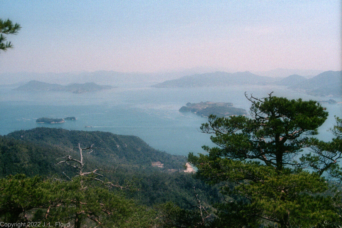
Islands in Hiroshima Bay, seen from summit of Mt. Misen
Miya Jima is a small island across the bay from Hiroshima. It is the site of Itsukushima Shrine, one of the most famous in Japan, and a place of spectacular beauty.
One reaches Miya Jima by taking a ferry from Hiroshima harbor. The trip takes less than half an hour and is worth going on in itself.
Leaving the dock at Hiroshima on the ferry to Miyajima
Cruise boat in Hiroshima Bay with amusement park ferris wheel in background.
View of Hiroshima from ferry en route to Miya Jima.
Aboard the ferry en route to Miya Jima. Although the vessel clearly had the capability to carry cars, there were none on board.
The ferryboats carrying people to Miya Jima were very cute.
The ferryboat dock at Miya Jima, with a boat departing from it.
Itsukushima Shrine is most famous for its “floating torii,” the red-orange gate built a few feet off the shore which at high tide appears to be floating in the water. At low tide, one can see the base anchored in the mud of the sea bottom. The buildings of the shrine itself extend over the water, constructed on piles driven into the sea bottom. I would guess that in a few years their interiors will be flooded by rising sea levels. The torii and the shrine proper present a striking appearance as one approaches the shore and are equally stunning as seen from the shore itself.
At the water’s edge near the shrine, I encountered sika deer being fed by local women. As in Nara, the deer are considered sacred – indeed, so is the entire island, and everything on it. For example, trees are sacred and may not be cut down.
The island is also part of Setonaikai National Park, the largest national park in Japan, a huge area which encompasses 3,000 islands and the waters around them.
The floating torii of Itsukushima Shrine leaps up out of the water as you approach the shore.
In the center the Toyokuni 5-story pagoda is seen, flanked by Senjokaku Pavilion on right. The latter dates from the 16th century, the pagoda from 1407.
It's hard not to overdo it by taking a tiresome number of pictures of the floating torii, and I have to confess that I failed abysmally.
Again the Toyokuni 5-story pagoda and Senjakaku Pavilion, built by Hideyoshi Toyotomi, second great unifier of Japan, contemporary of Philip II of Spain and would-be conqueror of Korea, in the 16th century.
Floating Torii at High Tide
The Itsukushima Floating Torii at low tide.
The deer at Itsukushima Shrine are considered sacred, as messengers of the gods. They are quite tame.
Itsukushima Shrine at low tide.
The beach at Miya Jima is a pleasant place to relax and take in the view of Hiroshima Bay.
Like many of the islands of Japan, Miya Jima rises abruptly out of the sea; the highest peak, Mount Mizen, soars to 535 meters (1755 feet).
Hikers trudge along the beach near the Floating Torii.
The front porches of some of the shrine buildings are built for access by boaters.
Aki no Miyajima is one name for the Itsukushima Shrine. Here we see the porches built over the water.
Scene from the Kangensai (festival) of Itsukushima Shrine.
The Kangensai Festival features demons who dismember the attendees. Fortunately, I did not attend the festival, which is held in June.
The shrine buildings extend over the water and are supported on pilings driven into the sea bottom.
I was gone by sunset, so I couldn't have taken this picture, which was shot by a true professional and serves as a fitting farewell to Miya Jima.
After touring the shrine, I wandered about the paths of the lower island for a while before taking the sacred cable car to the top of the sacred mountain, Mt. Mizen. Early on I encountered a colorful statue out of a comic book, looking somewhat like a pirate, who appeared to be directing traffic or, more likely, telling cars to turn around and go home. I never found out who this figure was supposed to represent, but he was a welcome relief from the general solemnity of the shrines.
Shortly afterward I came across Toyokuni Shrine with its striking red five-story pagoda, built in 1407, which I had glimpsed earlier from the ferry. It stands near the Senjokaku Pavilion, the largest building on Miyajima; its name means “Thousand-tatami pavilion.” Its construction was initiated by Hideyoshi Toyotomi (the “Taiko” Nakamura of Clavell’s novel Shogun) in 1598 as a place for chanting Buddhist sutras for Japanese warriors killed in battle in his many campaigns. Hideyoshi was the second great unifier of Japan at the end of the chaotic Sengoku Jidai period of the 16th century; he was a talented general of peasant origin who quickly put down the rebellion of Akechi Mitsuhide, assassin of Oda Nobunaga, and in short order repeated Nobunaga’s achievement in bringing the powerful warlords, the daimyo, to heel. Then, in 1592, to keep the daimyo occupied and glorify himself, he undertook an invasion of Korea, conceived as a first step toward the conquest of Ming China and then of all East Asia, if not the world. After spectacular initial successes, the invasion was frustrated first by the decrepit but still functioning Ming government, which dispatched a relief army to the aid of the Koreans; and finally by the Korean navy, under Admiral Yi Sun-sin, which eventually destroyed the Japanese fleet, leaving the Japanese army stranded and unable to resupply itself. When Hideyoshi died in 1598, the regents who first took over from him ended the Korean adventure and discontinued work on the Senjokaku Pavilion, which was also left unfinished by the succeeding Tokugawa Shogunate. In 1872, following the Meiji Restoration, the Senjokaku was converted to a Shinto shrine and rededicated to the memory of Hideyoshi.
Near the 5-story pagoda and the Senjokaku Pavilion stands a small but elegant Shinto shrine, the name of which I never found out.
While wandering amidst peaceful rustic lanes teeming with cherry blossoms, I stumbled into beautiful Momojidani Park, famed for its more than 200 maple trees of several different species. In autumn, when the maple leaves turn red, yellow and orange, the park presents a riot of color. It is a mecca for picnickers and also has one of the loveliest bridges in Japan.
Strolling on a rustic lane of Miya Jima, amidst the cherry blossoms.
Pirate directing traffic on Miya Jima, or maybe just telling the cars to go away. I never found out who the figure was supposed to represent.
Small Shinto shrine near Senjokaku Pavilion.
Toyokuni Shrine 5-story pagoda, framed by cherry blossoms; Senjokaku Pavilion at right.
Five-Storied Pagoda at Itsukushima Shrine, Miya Jima
Cherry blossoms on one of the hiking trails on Mount Misen, Miyajima, Japan
Picnickers in Momojidani Park, Miyajima. The park is famous for the profusion and variety of its maples.
Bridge in Momijidani Park. Said to be even more beautiful in autumn, when the maple leaves turn red.
From Momojidani Park it was a hop, skip and a jump to the cable car terminus at the base of Mt. Mizen. (They call the cable car a “ropeway,” but the ropes are of course steel cables.) It has two stops, one halfway up the mountain and another near the top. I got off at the first terminal and took a stroll along the paths there, before continuing on to the upper terminal.
Cherry blossoms obscure the view from a lane near the halfway cable car station on Mt. Mizen.
View of Hiroshima Bay from the cable car station at the halfway point.
Riding up the Miyajima "ropeway" (cable car) to the top of Mt. Mizen, 535 meters (1755 feet) high.
View of Miyajima and Hiroshima Bay from the cable car gondola near the top of Mt. Mizen.
The upper ropeway (cable car) station near the summit of Mount Mizen, as seen from the cable car.
Passing another gondola as mine approaches the upper terminus near the top of the mountain.
The observation deck at the top of Mt. Mizen affords breathtaking views of Hiroshima Bay and the Inland Sea.
View across the bay toward Hiroshima City from Mount Misen Observatory.
Islands in Hiroshima Bay, seen from summit of Mt. Misen
View of islands in Hiroshima Bay from the summit of Mt. Misen.
Another view of Hiroshima Bay from the slopes of Mt. Mizen.
The slopes of Mt. Mizen, with the Inland Sea and coast of Honshu in the background.
The pines on the summit of Mt. Mizen, with Hiroshima Bay in the background.
Islands in the Inland Sea, as seen from Mt. Mizen. This scene reminded me of the islands in the rock garden of Ryoanji.
Another view of the islands in the Inland Sea, framed by the pines on Mt. Mizen.
I wandered around the paths near the summit of Mt. Mizen for a while. This was the area that the sacred monkeys – Japanese macaques – were said to frequent, and indeed there were signs posted cautioning visitors to be wary of them, not to feed them, not to approach them, and even to avoid looking them in they eye – apparently they tended to regard that as a challenge. I had no problems; the few monkeys I saw were not interested in me or much concerned about my presence, and went about their business as if I were not there. However, Dave Winter said it was much different when he was there; wherever he went, the monkeys were lurking and they always looked him in the eye – he couldn’t avoid it. Maybe it had something to do with the season or phase of the moon. I have since read, however, that in 2010 the authorities decided to round up and deport the monkeys from Mt. Mizen, Stalinist-style, without asking them their preference, and transplant them to the Japan Monkey Center in Aichi Prefecture, near Nagoya. Actually, there was some justification for this, because it has since been determined that the monkeys had been watching Planet of the Apes and had thereby been inspired to plot the overthrow and subjugation of humans. Unfortunately, evicting the macaques from Mt. Mizen did not succeed in foiling their schemes; more recently, in Yamaguchi, a city down the coast from Hiroshima, a serious of ominous attacks on humans by macaques has taken place. Should anyone be unduly perplexed by this, I would like to point out that monkeys are primates, closely akin to humans, and share many of the vices and foibles of that species, including a penchant for violence. Also, one may speculate that the radiation released by the atomic bomb in 1945 quite likely could be responsible for many mutations among the fauna of southern Honshu, including the macaques, who may have had their evolution thus accelerated to develop more advanced intelligence, and used it to conclude that maybe they should get rid of humans before humans exterminate all other primates as well as themselves.
Sacred monkey grubbing around for his dinner on Mt. Mizen. Or perhaps he was planting explosives in preparation for the Planet of the Apes Revolt.
Sacred monkeys on Mt. Misen, Miya Jima. I understand that they have now been expelled from the island as a menace to tourists. They didn't bother me at all.
A sacred monkey expressing its opinion of me, atop Mt. Mizen on Miya Jima.
View across the bay toward Hiroshima City from Mount Mizen Observatory.
Returning down the mountain on the sacred cable car.
I returned to Tokyo the next day aboard the super-fast Nozomi Shinkansen. While waiting at Hiroshima Station to depart, I shot a few pictures of the train in the terminal before boarding the train. To my surprise, there was someone asleep in the seat that my ticket assigned to me. I felt reluctant to wake him up and ask him to move, but fortunately just at that moment someone came up and asked me, “Can I help you?” This was a frequent occurrence in train and metro stations in Japan – people were extremely helpful and liked to practice their English – and I explained the problem, showing him my ticket with its seat assignment. He looked at it and said, “Oh, this is the Hikari. You want the Nozomi!” He thereby saved me from an embarrassing mistake – otherwise I might have found myself several hundred miles up the line on the wrong train, going to the wrong place.
The Nozomi sped me back to Tokyo at 180 miles per hour, covering the 821 km/513 miles in about five hours (stopping in Kyoto). I was able to shoot a few pictures from the train windows – mostly rather boring scenes of Honshu farmland, but at least I was able to verify that there are open spaces in Japan. Unfortunately I fell asleep and missed a great shot of Mt. Fuji, waking just in time to see it go by but too late to grab my camera and set it up for the picture before it disappeared from view.
I am quite disappointed that high-speed trains of the Shinkansen type have not caught on in the USA. Long-distance travel in the United States is far too dependent on airlines, which seem to be getting more crowded, expensive and unpleasant with each passing year. The high-speed trains I have taken in Japan and Europe are far more pleasant and comfortable to ride than any airplanes I’ve been on. It’s obvious that the vast distances of the North American continent limit the applicability of train travel to the longest trips, such as coast-to-coast. Yet for short and medium distances, such as LA to Las Vegas or San Francisco, trains would seem to be a far better choice than airplanes. Yet the California high-speed rail project, which was projected to enable travel from LA to San Francisco in 3 hours, has so far taken 14 years and $5 billion to lay tracks to…nowhere. Originally projected for completion in 2020, it’s now estimated to be on-line by 2030, but only from Merced to Bakersfield. More ambitious plans for a nationwide high-speed train network during the Obama administration foundered on a combination of inexperience, mismanagement and political opposition. Critics never tire of pointing out that the countries where high-speed rail has been successful generally have more centralized or authoritarian governments than the US, where the competing jurisdictions of federal, state and local governments, in addition to the cost of purchasing land from private owners, drives the cost of building high-speed railways to astronomical levels and dictates that rail travel will always be uneconomical compared with automobile and air. I don’t buy this. Autos and airplanes are currently dependent on fossil fuels, which are obsolescent and must be eliminated as a major energy source if humans are to survive on this planet. Even if electric cars and trucks replace gasoline and diesel-fueled vehicles, and hydrogen becomes a viable fuel for airplanes, trains make more sense in lots of ways.
Boarding the Shinkansen at Hiroshima Station.
Passengers waiting for the Shinkansen in Hiroshima Station
Seating on the Nozomi was asymmetric - three seats on one side, two on the other.
Honshu farmland, seen from the Shinkansen en route from Hiroshima to Tokyo
View of Honshu farmland from the Shinkansen.
Honshu farmland, seen from the Shinkansen en route from Hiroshima to Tokyo
Honshu farmland, seen from the Shinkansen en route from Hiroshima to Tokyo
Genbaku Dome - formerly the Hiroshima Industrial Promotional Hall, now the Hiroshima Peace Memorial
As a historian, an American and a citizen of the world, I felt an obligation to visit Hiroshima. I wanted to deepen my understanding of what had happened on the terrible day of August 6, 1945, and to pay homage to the thousands who died there as well as the survivors who continued to suffer from the effects of nuclear radiation and social discrimination. And I wanted to see how the city had recovered from the ghastly catastrophe inflicted on it.
I arrived in Hiroshima on the Shinkansen on a sunny April day and immediately found my ryokan, which was a short walk away. It was a very plain, unremarkable room, tucked away in a high-rise building, sort of a cross between a hotel and a traditional ryokan – the only traditional aspect I remember was that the floor was covered with tatami rather than rugs. I have no need for luxurious hotels in any case and I found it quite comfortable for the two nights I was there.
I had a memorable dinner in a tiny hole-in-the-wall restaurant near the hotel. It was a bar-and-grill type of place where you sit at on stools at the bar and the food is cooked right in front of you. The specialty of the house was oekenomiyaki, a type of pancake featuring all sorts of ingredients cooked together in a delicious melange. The oekenomiyaki were exceptionally tasty as well as inexpensive, and I downed them with beers, none of which I paid for; as soon as the other patrons noticed a gaijin in the bar they started buying me beers and continued to do so for the rest of the evening. I felt honored beyond measure and I’ll always be grateful for the hospitality and good feelings accorded to me in Hiroshima.
Next morning I began my explorations at the Genbaku (Atomic Bomb) Dome, aka the Hiroshima Peace Memorial. Prior to August 6, 1945 it was known as the Hiroshima-ken Sangyo Shoreikan, the Hiroshima Prefectural Industrial Promotional Hall, built in 1914. Since then it has been preserved in a state as close as possible to its condition immediately after the bombing: a ruined skeleton. The intent was to preserve it as an overwhelmingly powerful symbol of the destructive power of which humans are capable, but also as an expression of hope for peace and the ultimate elimination of nuclear weapons (and, I would add, of all weapons of war) from the world.
The Industrial Promotional Hall was neither the intended target nor the actual ground zero of the atomic bomb. The intended target was the Aioi Bridge over the Ota/Motoyasu River, a few hundred feet away. The actual hypocenter was the Shima Surgical Clinic 800 feet to the east of the bridge and 490 feet east of the Industrial Promotional Hall. The bomb did not actually hit anything because it exploded 1,900 feet in the air over the hypocenter, but the blast leveled almost 70 percent of the buildings in Hiroshima and killed about 80,000 people, 30% of the city’s population. The Little Boy fission bomb dropped on Hiroshima was a primitive weapon by today’s standards, since only 1.7% of the fissionable material aetually ignited, a fact which would have been of little consolation to its victims. I mention this only to underline the apocalyptic nature of nuclear warfare and to reinforce the case for not engaging in it.
Genbaku Dome - formerly the Hiroshima Industrial Promotional Hall, now the Hiroshima Peace Memorial
Genbaku Dome - formerly the Hiroshima Industrial Promotional Hall, now the Hiroshima Peace Memorial
Genbaku Dome - as seen from Peace Memorial Park on the other side of Motoyasu River
Genbaku Dome, alongside Motoyama River
Aioi Bridge, original target of the atomic bomb, which missed and detonated over nearby Shima Surgical Clinic.
Shopping mall near the hypocenter of the atomic blast. The Shima Surgical Clinic was somewhere on the land now occupied by this mall.
Whenever I saw happy schoolchildren like those in the following pictures I could not help thinking about other schoolchildren who perished on August 6 in Hiroshima and on August 9 in Nagasaki. I’d rather it didn’t happen again.
Japanese school children visiting a park
Schoolgirls feeding pigeons, Hiroshima, Japan
Schoolgirls feeding pigeons
But the nuclear attacks weren’t really much different in their effect from the holocaust that occurred in the firebombing of other Japanese cities – such as Tokyo, where on March 9-10, 1945, the single most destructive air raid in human history resulted in the deaths of over 100,000 civilians. Such horrors might be considered just retribution for the Japanese invasion of China, during which millions of Chinese civilians and soldiers perished. But that leads into a long chain of cause and effect which involves the impact of 19th-century Western imperialism in East Asia and elsewhere, and I’m not going there. The point here, the lesson of Hiroshima, is that this madness has to stop. Nations have to learn to cooperate rather than destroy one another. Otherwise there is no future for humanity on this planet. Are you listening, Vladimir Putin?
The Hiroshima Peace Park, located on an island across the river from the Genbaku Dome, reinforces this message. It contains a museum and a number of monuments. Near the entrance of the museum is a clock with the hands frozen at 8:15, the time the atomic bomb went off. The exhibits and information include coverage of events leading to the war, Hiroshima’s role in the war, and of course the bombing and its effects.
In the center of the park is a cenotaph – an empty tomb commemorating people whose remains are buried elsewhere – honoring the victims of the bomb, whose names are recorded there. A concrete arch, representing a shelter for the souls of the victims, covers the cenotaph. There is a second cenotaph in the park for Korean victims of the bomb; there were some thousands of Koreans working as co-opted laborers in Hiroshima at the time of the bombing.
In front of the cenotaph there is also a Flame of Peace, ignited in 1964; it is supposed to continue burning until all nuclear weapons have been eliminated from the world.
There is also a Peace Bell, located in a gazebo in the park. Although it was donated by the Greek embassy, it is a Japanese-style bell cast in Japan. On it are inscriptions in Greek, Japanese and Sanskrit. Visitors are encouraged to ring it, which they do often.
The most poignant monument in the park is the Genbaku no Ko no Zō, the Children’s Peace Monument, built in 1958 with funds donated by Japanese school children. It commemorates all the children who perished from the atomic bomb, but especially Sadako Sasaki, a girl who was two years old when the bomb struck, and later died of leukemia contracted as a result of radiation exposure. Before she died in 1955, she undertook a project of folding a thousand origami paper cranes (senbazuru). In Japanese legend, the crane is a magical bird, living for a thousand years, and a person who folds one thousand origami cranes in a year will be granted a wish by the gods (in some versions of the legend, long life or eternal bliss). There is some uncertainty about whether Sadako completed the project before she died—family members say she did—but in any case she passed away at the age of 12, and the Children’s Peace Monument honors her memory. A statue of Sadako stands on top of the monument, holding a wire crane above her head. From the ceiling of the gazebo-like monument structure hang sheafs of paper cranes on strings, contributed by children from all over Japan and from around the world, and continually replenished as they succumb to the weather, and thousands more are stored in glass boxes around the monument.
Hiroshima Peace Memorial Museum, with Hiroshima Victims Memorial Cenotaph and Flame of Peace in front
Another view of Hiroshima Peace Memorial Museum
Hiroshima Victims Memorial Cenotaph, with Flame of Peace and Genbaku Dome in background
Peace Fountain in front of Peace Memorial Museum
Prayer for Peace Bell, Peace Memorial Park
Flame of Peace in Peace Memorial Park, Hiroshima
Monument to School Teacher and Child Victims of the Atomic Bomb, Peace Memorial Park
Children's Peace Monument, Peace Memorial Park
Paper cranes at base of Children's Peace Memorial. The crane is a symbol of peace.
While the Genbaku dome and Peace Park in themselves provide sufficient reasons for going to Hiroshima, there are other incentives also. Not the least important is the island of Miya Jima, across the bay from Hiroshima, but I am giving it a page of its own, so I’ll end this page with a few scenes from around the city. Some of these, representing views I was not able to see or photograph in person, are taken from photos I did not take personally but acquired by other means. Unfortunately I’m unable to give proper credit to the sources as I no longer have the originals from which the pictures were digitized.
Hiroshima-eki - tram stop in front of the railway station. Trams (streetcars) were the main mode I used to get around in Hiroshima.
Most urban-dwellers in Japan live in apartment buildings, though not all of them are as massive or anonymous as this one.
Hiroshima city streets from my hotel room.
Hydrofoil boat on Motoyasu River. Following World War II, Japan became an advanced country in all modes of transportation.
A night view of Aioi Bridge, the original aiming point for the atomic bomb dropped on August 6, 1945. (From a postcard.)
A picture-postcard view of Hiroshima City from a mountain vantage point above it.
Another postcard view of Hiroshima City.
Shukkei-en, a lovely garden in Hiroshima.
Completely destroyed by the atomic bomb explosion, Hiroshima Castle was rebuilt after the war. Unfortunately I didn't get a chance to see it in person.
I should note in passing that Hiroshima is also the site of the headquarters of Mazda Motor Corporation, though I was unaware of it at the time, so I don’t have any pictures to show for it.
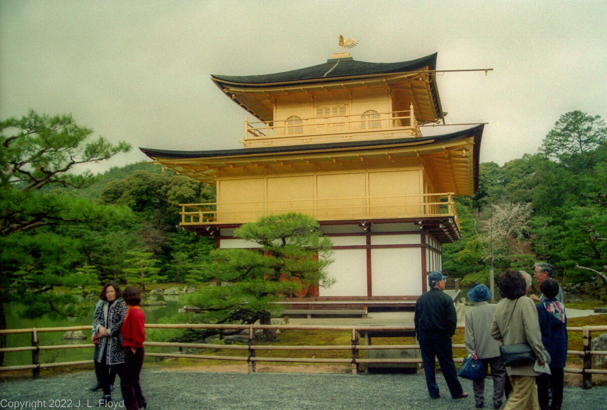
Rokuon-ji, Deer Garden Temple, a Zen Buddhist temple in Kyoto, commonly known as Kinkaku-ji, "The Golden Pavilion." Dates from 1397.
Traveling to Kyoto, the old Imperial capital of Japan, gave me a chance to ride on the Shinkansen, Japan’s famous bullet train. The Shinkansen comes in two versions – the Hikari, which is very fast, and the Nozomi, which is faster yet and makes fewer stops. I took the Hikari to Kyoto, and although it was too late in the day to do much sightseeing, I did walk around a little in the Gion district, where I had booked my room at a modest but comfortable local ryokan, the Rikiya.
Construction near Kyoto Station
As I arrived in Kyoto, I observed that a new station was under construction to replace the existing one, which had been built in 1952.
New Train Station
The new station was going to be the second-largest building in Japan (Nagoya Station is the largest). It was completed in 1997.
New Kyoto Station - Karasuma Side
The new station incorporated a shopping mall, hotel, movie theater, department store, and several local government facilities under one 15-story roof.
Ryokan Rikiya
My lodging in Kyoto was this ryokan located in Gion, the so-called geisha district. It was quite comfortable, although there were no geishas there.
Motorcycle dealership
Although Kyoto, with its rich legacy of history and culture, has many extraordinary attractions, I took a few pictures of ordinary, mundane establishments that would be found in any modern city, such as this motorcycle dealership.
Gas station
Another humdrum item you can't avoid in the modern world, hardly worthy of a photo.
Teahouse in the park
But this elegant teahouse in a Kyoto park did seem worth a snapshot.
The next morning I got up and took a short train ride to Nara, spending the entire day there; the following two days I devoted to seeing Kyoto.
At Kyoto Station I had signed up for a morning walking tour conducted by a local guide who styled himself as Johnny Hillwalker, aka Hiruka Hajime. I met him, along with the rest of a party of 5-6 people, on a rainy, chilly spring morning at Kyoto Station. Johnny, a retired JNTO guide, proved to be a highly affable, entertaining and knowledgeable host, and of course his English was flawless. His fee was more than reasonable – I suspect that he did the tours more to keep fit and busy than to supplement his income.
The rain was pouring down as we began our walk; it didn’t dampen our spirits, but it did impede photography somewhat – I had to be careful to avoid flooding my camera, which was not waterproof. So I took fewer pictures than I would have preferred. Later in the day, when the sky began to clear, I made up for lost time.
The walk, if I remember correctly (it’s been a long time) lasted about 3-4 hours; we visited several temples, shrines, gardens and a few local shops such as bakeries and ceramics makers.
Johnny Hillwalker
Johnny Hillwalker, aka Hiruka Hajime, our guide for a rainy-day morning walking tour of Kyoto.
The Snow-Capped Bridge
The Snow-Capped Bridge in Shosei-en Garden, one of the first places we visited with Johnny Hillwalker.
Rained-on Bridge
Another view of the Snow-Capped Bridge in Shosei-en Garden. On this day it was not snow-capped but rather rain-washed
Higashi Honganji Temple bell.
Our tour guide, Johnny Hillwalker, gives us the scoop on the Higashi Honganji Temple bell. He was quite familiar with it since he attended services there.
Picturesque bridge
One of the bridges we crossed on our walking tour.
Higashi Otani Cemetery
Higashi Otani Cemetery, Kyoto, Japan. Since most Japanese are cremated, burial does not take much space.
Deva gate, Kiyomizu-dera
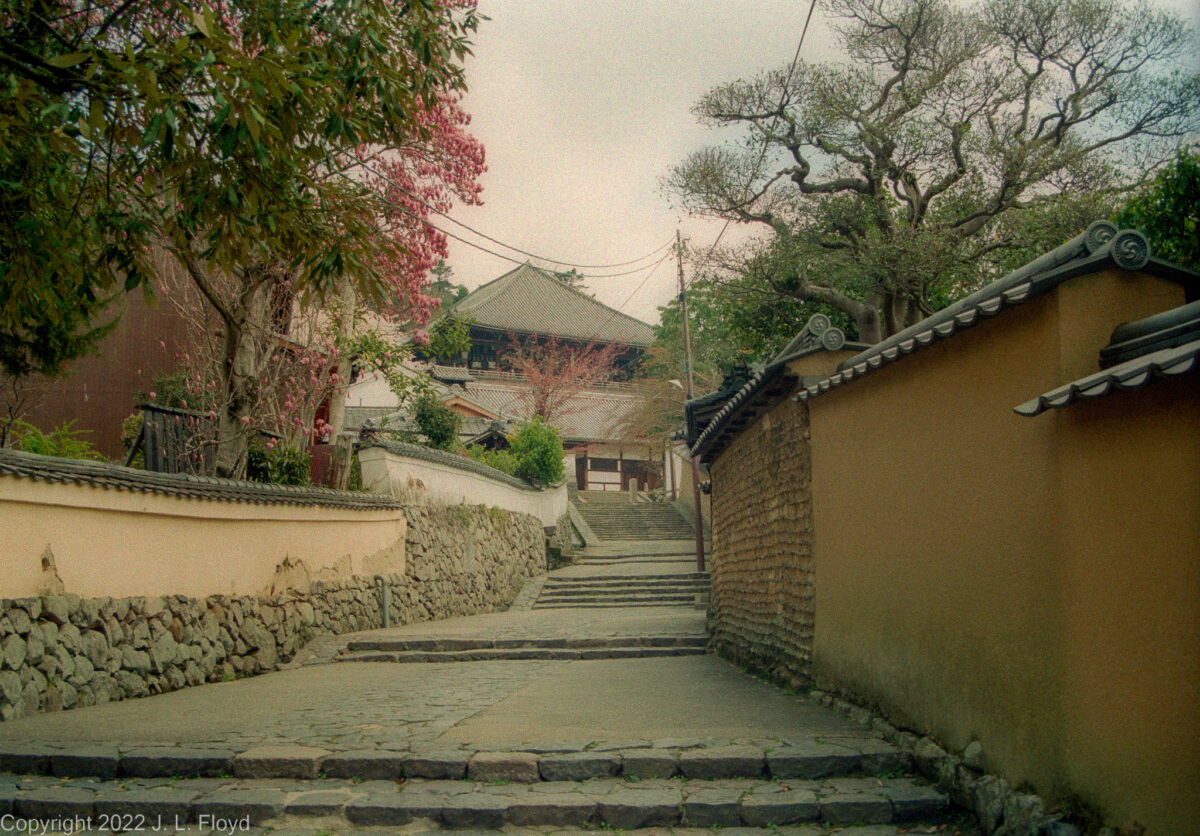
Our walking tour ended here at the Deva gate at Kiyomizu-dera (temple), which overlooks Kyoto from the foothills of Mount Otawa.
From Johnny Hillwalker I got good directions on how to reach the attractions I most wanted to visit, which were mostly far away in the northwest part of Kyoto – the railway station and Gion are in east-central Kyoto. In the meantime I picked up where the morning walk had ended and checked out some more of the sights in Gion.
Gion is the entertainment district of Kyoto, and it is inextricably associated in the popular mind with geishas (or geiko as they are known locally). I had no particular interest in meeting up with any geishas; I had done enough research – and absorbed plenty of sage advice from Dave Winter – to know that quality geisha performances were likely to be (a) very expensive and (b) mostly unavailable to Westerners, except wealthy or well-connected ones, and I was neither. But I did feel a need for at least some cultural exposure, and I had a free evening, so I bought a ticket for a performance at Gion Corner, which, in the words of one website, offers a “budget experience…a contrived one-stop shop for geisha entertainment open nightly from 6 p.m. that panders to tourists with tea ceremonies, puppets, flower arrangement, music and dancing.” As the description suggests, it wasn’t especially memorable, but neither did it bankrupt me at about $28.
The real glory of Kyoto is in its historical sites and artistic marvels. From 794 to 1868, when Emperor Meiji migrated to Tokyo, Kyoto was the seat of the Emperor and the cultural metropolis of Japan. (The stretch from 794 to 1185 is known as the Heian period, because the original name of Kyoto was Heian-kyo.) It still retains much of that aura, not least owing to the fact that it was spared the firebombing that destroyed Tokyo and other cities during World War II. This was thanks to Secretary of War Henry L. Stimson. When army generals proposed Kyoto as a first target for the atomic bomb, Stimson, who had honeymooned in Kyoto and was familiar with the city, forcefully quashed the idea, on the grounds that Kyoto was a repository of priceless cultural treasures and could not be bombed.
There are too many such treasures in Kyoto to see in a couple of days; it would have taken months to see them properly. I was able to visit and take pictures of a few of the sites I had heard most about, and you can see them here, along with a few shots of places I missed but picked up from other sources.
Kiyomizu-dera Temple
Kiyomizu-dera is a Buddhist temple founded in the eighth century; the present buildings were erected in 1633 on a commission from the shogun Tokugawa Iemitsu.
Niomon (Deva gate) at Kiyomizu-dera
A niomon is a Buddhist temple gate guarded by two wooden warriors called nio. They are located inside the gate and cannot be seen in this picture.
Main Gate of Heian Shrine
Heian Shrine was built in 1895 as a 5/8 scale of the Heian-era Imperial Palace, to commemorate the 1100th anniversary of the transfer of the Imperial Capital from Nara to Kyoto.
Heian Shrine Garden
The pond is a haven for rare species of turtles.
The Dump
Not all places in Japan are neat and clean. I came across this neglected graveyard for old bicycles en route to one of the Kyoto temples.
Ryozen Kannon Temple
Buddhist temple featuring a 24-meter-tall, 500 ton statue of Kannon, the bodhisattva of compassion.
1001 images of Kannon
1001 images of Senju Kannon, the Buddhist bodhisattva of compassion, stand in Sanjusangendo Temple.
Boddhisattva Kannon
700-year-old, 11-foot-tall statue of the Boddhisattva Kannon, carved of cypress wood covered with gold leaf, in Sanjusangendo Temple.
Rokuon-ji, the Golden Pavilion
Rokuon-ji, Deer Garden Temple, a Zen Buddhist temple in Kyoto, commonly known as Kinkaku-ji, "The Golden Pavilion." One of the most popular attractions in Kyoto.
Kyoko-chi - Mirror Pond
Kinkaku-ji's pond reflects the Golden Pavilion rather nicely.
Kinkaku-ji and its pond
Kinkaku means gold in Japanese; the pavilion is literally covered with gold leaf.
Kinkaku-ji, the Golden Pavilion
Still another view of Kinkaku-ji and its reflection in Kyoko-chi Pond.
My ultimate destination in Kyoto, the one place I had come to see above all others, was the Zen rock garden known as Ryoanji. Along with the Alhambra in Spain, it was one of the two places in the world I wanted most to visit. I had first encountered Ryoanji in Edwin Reischauer and John Fairbanks’ college textbooks on Asian history, one of which actually had a picture of the garden; I had wanted to see it in person ever since. I find that the esthetic that elevates an assembly of plain, unadorned rocks to the epitome of artistic achievement has a powerful appeal. I lingered there for a couple of magical hours and shot more pictures of the shrine and the garden than of any other attraction I visited in Japan, and I’m giving it a special section as the culmination of my visit to Kyoto.
Approaches to Ryoanji Temple, Kyoto, Japan
Ryoanji Temple - The main building (kuri) in autumn
The torii at the entrance to Ryoanji Temple.
Ryoanji Temple has a back yard.
The stone wash-basin (tsukubai) for the Zorokuan tea-room.
Ryoanji Temple - the Tea Room Zorokuan
Kyoyochi Pond at Ryoanji Temple
Kyoyochi Pond at Ryoanji Temple
Spiraea thunbergii at Kyoyochi Pond
The kare-sansui (dry landscape) zen garden at Ryōan-ji Temple.
Another perspective on the kare-sansui (dry landscape) zen garden at Ryōan-ji
The splendor of cherry trees in bloom contrasts with, and so enhances, the austere beauty of the rock garden.
Japanese cedars provide a pleasing backdrop for the rock garden.
The rock garden appears to me as a vast Pacific seascape dotted with small volcanic islands.
The jagged island thrusting abruptly out of the sea reminded me of some of the Hawaiian Islands.
Ryoanji Temple - Rock Garden in spring with cherry blossoms; this is what it looked like when I was there.
I never tired of looking at the Ryoanji rock garden; I remained sitting there until spring turned to winter, and then shot these last two pictures. Actually, of course, I got them from postcards.
I thought that the rock garden presented an especially sublime appearance with the snow on the trees and the rocks.
One of many ancient and beautiful Buddhist temples in Nara.
Nara was the capital of Japan, the seat of the Emperor, from 714 to 794, which is known as the Nara period. Subsequently the capital was moved to nearby Heian, which later became known as Kyoto. Today Nara is a medium-sized provincial city of 367,000 people.
Buddhism had arrived in Japan a couple of centuries earlier, and Nara became a major center of Buddhist worship; it still has many Buddhist temples and shrines. According to legend, Takemikazuchi – the god of thunder and swords – arrived in Nara riding on a white deer to take the city under his protection, and since then the deer have been regarded as sacred protectors of the city. They roam freely about the city, getting in the way of people and cars and soliciting food from passers-by, to whom vendors sell snacks for that very purpose. I didn’t feed them myself, but I enjoyed having them around.
A Street in Nara
Nara, once the capital of Japan, is now a quiet provincial town overshadowed by nearby Kyoto and Osaka.
Deer Jaywalking
The deer in Nara are sacred and running them over with your car is frowned upon.
Sacred deer in Nara Park
These are native Japanese sika deer, but they look like any old white-tailed deer to me.
Deer grazing on cherry blossoms
Deer grazing on fallen cherry blossoms in Nara Park. I didn't know that deer ate cherry blossoms, but why not? There are plenty of them around in the spring.
Nara-19960415-0072
I'm not sure what kind of establishment this is - most likely a Buddhist temple, of which there are many in Nara.
Peaceful byway
This quiet and peaceful lane, presided over by a cherry tree in bloom, leads to another Buddhist temple in Nara.
Secluded Buddhist temple
One of many ancient and beautiful Buddhist temples in Nara, located at the end of the quiet lane seen in the previous photo.
Buddhist temple
Another pretty Buddhist temple in Nara.
I visited several Buddhist temples, of which the most prominent was Todai-ji, founded in 738. It contains the world’s largest bronze statue of the Buddha, known as Daibutsu in Japan.
Pedestrian walk to Todai-ji
Pedestrian walk leading to Todai-ji Nandaimon, the Great South Gate at Todai-ji Temple, completed in 1203.
The Great South Gate
Sacred deer lurk by Todai-ji Nandaimon and demand to be fed by passers-by, threatening to eat them if not fed.
Feeding the sacred deer
The gentleman with the pony tail generously donated his lunch to the deer, or maybe he just didn't want to be eaten by them.
Agyo
Agyo, one of two great gate guardians within Nandaimon, the Great South Gate of Todaiji.
Great Buddha Hall
The Great Buddha Hall, Todai-ji Temple. Originally built in the 8th century, twice rebuilt after fires, most recently in 1709. Until 1998 it was the world's largest wooden building.
Todaiji Temple Interior
The dark and cavernous interior of the Todaiji Temple.
Todaiji Dabutsu in Nara
Todaiji Dabutsu in Nara. Completed in 752 CE, it is 50 feet tall and weighs 500 tons.
Good Karma Column
A supporting post in the Daibutsuden has a hole said to be the same size as one of the Daibutsu's nostrils. Legend has it that those who pass through it will be blessed with enlightenment in their next life.
Komokuten
Komokuten, one of a pair of guardians in the Daibutsuden (main hall) of Todai-ji Temple
Belfry
The belfry at Todai-ji
The Great Bell at Todai-ji
The bell in the belfry at Todai-ji Temple.
Next to Todai-ji is the Isui-en Garden, which is noted for its use of “borrowed scenery”, meaning that the architects incorporated external elements, specifically the Nandaimon or South Gate of Todai-ji Temple as well as some of the mountains around Nara, when framing the landscape of the garden. It is a vast garden, occupying 13,500 square meters or 145,000 square feet, and is actually a combination of two separate gardens, the smaller dating from the 17th century and the other from 1899. Both were created by wealthy merchants and were bought and combined by a third businessman in 1939. The garden contains large ponds, fed by a nearby river, and a couple of pleasant tea-houses. I found this garden – among many others in Japan – immensely pleasing and soothing. I never cease to be amazed by the Japanese sense of esthetics, and nowhere is it expressed more eloquently than in their gardens.
Another great temple of Nara is Kofuku-ji, located not far from Todai-ji and Isuien Garden. I should emphasize that there are many more wonderful temples and shrines in Nara than these, and I regret that I didn’t have time to explore them all.
Nanen-do, Kofukuji Temple
Worship hall & pilgrimage site first built in 813, housing an ornate, 8-handed deity sculpture.
Gojuno-to - Kofukuji Temple
Gojuno-to - Five-story pagoda at Kofukuji Temple, built around 730 AD. Note the TV broadcasting antenna on top. Even in the 8th century, Japan was a technologically advanced civilization.
Sorin Finial
8th-century TV broadcasting antenna removed from the top of a pagoda and stuck in the ground. (The Japanese call it a Sorin finial.)
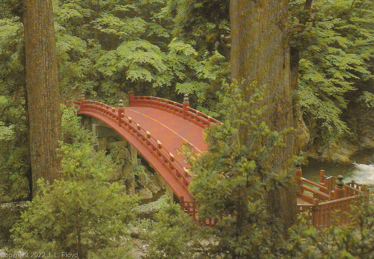
Sacred Bridge over the Daiya River, 27 meters long and 6 meters wide; used only on ceremonial occasions.
At Dave Winter’s recommendation, I booked a trip to the resort town of Nikko, about a 6-hour train trip north from Tokyo. It’s a slow local train, not the Shinkansen; the ride is leisurely and fun.
Nikko is a popular tourist destination and I can certainly understand why. It is a beautiful place, set in a forest in the mountains, with rivers, waterfalls and hot springs aplenty. It is also the site of the mausoleum of Tokugawa Ieyasu, founder of the Tokugawa shogunate and one of the most significant figures in Japanese history.
I arrived in Nikko in the late afternoon of a sunny April day and was immediately whisked off in a Toyota Camry to my lodging, a traditional Japanese inn (ryokan), driven by the hostess of the establishment. Everything in Japan is expensive these days, and has been since the 1970s, but the ryokan’s rates were very reasonable, the room was plain but comfortable, and the meals were fabulous. At dinnertime I met a German tourist who was hiking through Japan on a six-week vacation from his business – he owned a printing company in Cologne. Like most educated Germans, he spoke excellent English (sadly I’ve forgotten most of my German) and we had a fun evening drinking sake and swapping lies.
Main street of Nikko
Nikko, a town of 80,000 nestled in the mountains north of Tokyo, preserves a small-town atmosphere.
Honda van parked in Nikko
This Honda van represents a model I hadn't seen before, and have never seen in the USA at all.
Turtle Inn
The ryokan (traditional Japanese inn) where I stayed in Nikko was plain but comfortable, and the dinners were fabulous.
At ease
An illustrious samurai relaxes on a futon after a long day of travel. Thanks to the hostess for taking the picture.
Next morning I began my explorations of the Nikko antiquities. There are three main shrines at Nikko – the Toshogu, the Rinnoji Temple and the Futarasan. The most elaborate, and the one I devoted most attention to, is the Toshogu, the mausoleum of Tokugawa Ieyasu.
The Toshogu shrine was initially established in 1617, shortly after Ieyasu’s death, under his son and successor Hidetada. In the 1630s Ieyasu’s grandson Iemitsu greatly enlarged and elaborated it. One approaches the shrine via a stone Shinto ceremonial gate or torii, known as the Ishi-torii, at the end of a long flight of stone steps. Next to the Ishi-torii is a tall red pagoda, the Gojunoto, whose five stories each represent one of the five elements – earth, water, fire, wind and ether, in ascending order.
The main shrine area lies beyond the Omoteimon, a gate where one pays an entrance fee. Proceeding further, one encounters a series of ostentatious storage sheds and a stable for sacred horses; these feature elaborate woodcarvings by famous artists, which are among the most cherished treasures of Japan. Continuing up the hill, one passes under a copper torii to reach the famous Yomeimon gate, an incredibly ornate structure which is considered to be so beautiful that one can stare at it all day until sundown without ever getting tired of looking. Continuing on a somewhat circuitous route, one next comes to the Karamon, or Third Gate, also known as the Chinese Gate, leading to the main shrine building, which contains the praying hall (haiden) and main hall (honden). In the honden is an effigy of Tokugawa Ieyasu, somewhat idealized; in later life he was a very fat man, and by the time Will Adams met him in 1600 he was already far from the trim and robust horseman depicted by Clavell in Shogun – he already had difficulty mounting a horse by the time of Sekigahara – though he did enjoy falconry until the end of his life.
But this isn’t the end of the Toshugu odyssey. Next, one passes through the Sakashitamon Gate, which features a renowned carving of a sleeping cat, and continues on a tortuous flight of stone steps up the hill to still another torii leading to the Inner Shrine. Finally, after passing through the Inukimon Gate, one arrives at the mausoleum proper, containing Ieyasu’s tomb, a relatively simple but dignified funerary urn. Off to one side of the compound stands the Wish-Granting Tree, an ancient cedar which predates the mausoleum; generations of pilgrims have believed that if one prays facing the hollow of the tree, their wishes will be granted.
Ishidorii - Entrance to Toshogu Shrine
A steep stone staircase leads to the Ishidorii, the stone torii (Shinto gate) at the entrance to Toshogu Shrine.
Gojunoto - five-story pagoda
Near the entrance to the Toshogu Shrine. The original was donated by a daimyo in 1650, but burned down and was built anew in 1818.
Copper torii
This copper torii stands in front of the steps leading to the Yomeimon Gate. On the balcony at the top of the steps is the Drum Tower.
Rinzo Shrine and Miyuza
Behind the torii is another small shrine (shrinelet?), the Rinzo. On the left is the Miyuza, a kiosk sheltering a stone basin used for ritual purification.
Lanterns at the Yomeimon steps
By the wall on either side of the steps leading to the Yomeimon gate are iron lanterns donated by Date Masamune, who was originally a rival of Tokugawa Ieyasu but eventually became one of his most faithful supporters and survived him.
The Yomeimon Gate
Yomeimon - richly decorated two-story second gate to Toshogu Shrine, dating from 1636.
Kamijinko storehouse
Kamijinko, a storehouse dating from the early Edo period, sports some interesting carvings beneath the eaves.
Kamijinko carvings
Carvings beneath the eaves of the Kamijinko storehouse include elephants and a sleeping cat, one of several at Toshogu.
Three Wise Monkeys
This carving of the Three Wise Monkeys (see no evil, hear no evil, speak no evil) decorates-the stable housing the sacred horses of Toshugu Shrine.
Three Wise Monkeys - closeup
The Three Wise Monkeys are a traditional symbol in Japanese (and now world) culture.
Oranda Doro - Dutch Lantern
Oranda Doro - the Dutch Lantern, a gift from the Dutch East India Company to the shogun in 1643.
The Shinyosha
The Shinyosha, a structure for storing mikoshi (portable shrines), in the courtyard of the Toshogu Main Shrine (behind the Yomeimon Gate), dates from 1636.
Karamon Gate
Karamon - Third Gate or Chinese Gate - Haiden (prayer hall), and Honden (main hall)
Nemuri-neko - Sleeping Cat
The Sakashitamon Gate, which leads to the inner shrine, is decorated with a carving of a sleeping cat (nemuri-neko) among peony flowers.
Tosho Daigongen
Deified image of Tokugawa Ieyasu (Tosho Daigongen), in the honden of Toshogu Shrine. In real life he was much fatter than he looks here.
Tomb of Tokugawa Ieyasu
Tomb of Tokugawa Ieyasu. Supposedly the urn contains his remains, though there is some uncertainty about this.
The second major establishment at Nikko, the Rinno-ji is a temple of the Buddhist Tendai sect, founded in 766 by a monk named Shodo Shonin. But it also administers the Taiyu-in Reibyo, which is a Shinto shrine and the mausoleum of the third Tokugawa shogun, Iemitsu. This is indicative of the fusion between Buddhism and Shinto during the many centuries after Buddhism became established in Japan around 538 AD. In the main Rinnoji temple stand three statues of Buddhist “deities” (technically, Buddhism does not recognize any gods) who also represent the kami (spirits) of the three mountains of Nikko, who are also Shinto manifestations.
Rather than the temple itself, I focused on the mausoleum. Iemitsu, the third Tokugawa Shogun, Ieyasu’s grandson, became shogun in 1623, when his father Hidetada retired, but only became the de facto ruler in 1632, when Hidetada died. Iemitsu’s reign is noted for the suppression of Christianity and the “closing” of Japan to foreign contacts and influences. As early as the 1590s Japan’s rulers had issued edicts outlawing Christianity, but the these had only been sporadically and half-heartedly enforced; Iemitsu’s regime began a systematic effort not only to suppress Christianity but to exclude Westerners and Western influences in general. This culminated in the Sakoku Edicts of 1635, which forbade Japanese from travelling abroad or Westerners from settling in Japan, under penalty of death; prohibited the Christian religion; and limited trade contacts to one Dutch ship per year, restricted to the island of Deshima at Nagasaki. Thenceforth known or suspected Christians were required to demonstrate their renunciation of the faith by stamping on pictures of Jesus or Mary. Thousands who refused to do so were executed, often by crucifixion. These policies continued to be enforced until 1858, when the Americans compelled the by-then tottering shogunate, under threat of force, to open up the country to trade with Western powers.
Second Gate (Niten-mon)
Taiyū-in Reibyō Nitenmon, Second Gate (Niten-mon) of the Mausoleum of Tokugawa Iemitsu at Rinno-ji Temple complex
Another Buddhist kami
Another Buddhist kami guarding the mausoleum of Tokugawa Iemitsu, Nikko, Japan.
Jikoku-ten (green skin)
One of the two guardian kami (spirits) at the Niten-mon (Second Gate) of the Taiyu-in Mausoleum; he protects the east sky.
Komoku-ten (red skin)
Buddhist kami (spirit) who protects the west sky, at the Niten-mon (second gate) of Taiyu-in Mausoleum.
Bell Tower
This unique structure is Rinnoji Temple's bell tower.
Another sleeping cat
One of several decorating the various Nikko shrines. The sleeping cat is considered to be a symbol of peace.
The Nikko shrine complex is quite large, and, well, complex, and I had only a day to see it all; after traversing Toshogu I had only a limited time to explore Rinnoji and Futarasan. The latter, especially, is somewhat dispersed and vaguely defined as to extent, and I wasn’t able to reach all of its outlying sites. Here I have included in the gallery, in addition to the known Futarasan sites I visited, items that were probably not associated with Futarasan but which I could not classify with either Toshogu or Rinnoji.
Futarasan was founded in 767 by the same Buddhist monk who founded the Rinnoji Temple. The main shrine is located to the west of Toshogu, but for lack of time I bypassed that in favor of the Taiyu-in Reibyo, Iemitsu’s mausoleum, which is located nearby. I did, however, manage to see and photograph some of the most spectacular outlying Futarasan sights, notably the Kegon Falls and the Sacred Bridge.
A nice place to be
I never found out whether this modern-looking building belonged to Futarasan, Toshogu or Rinnoji, but the setting was worth a picture.
A garden spot
The building in the background may be part of Rinnoji Temple or Futarasan Shrine. In any case, I much admired the quiet stream, lush garden and charming stone bridge.
Watarase River
Fisherman on the Watarase River, one of two rivers which flow through Nikko.
The Kegon Waterfall
The Kegon Waterfall at Lake Chuzenji, near Nikko, is associated with the Futarasan shrine. It falls 330 feet, into a basin that is 66 feet deep.
Sacred Bridge
Sacred Bridge over the Daiya River, belonging to Futarasan Shrine. It is 27 meters long and 6 meters wide; used only on ceremonial occasions.
Shinkyo Bridge
Another view of the Sacred Bridge over the Daiya River.
A well-earned rest
In a kimono provided by the ryokan hostess, the intrepid samurai relaxes on his futon in the Turtle Inn at the end of a grueling day of exploration. Taken by the hostess of Turtle Inn.
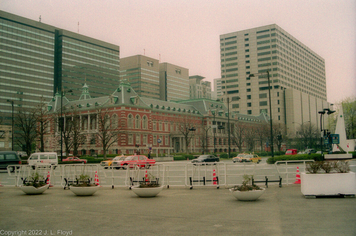
Tokyo Station, the main inter-city railway station in Tokyo; Marunouchi (west) side.
On my second day in Tokyo I came down with a mild case of the flu, and it slowed me down a bit for the next couple of days. I cut short my visit to the Imperial Palace and didn’t take as many pictures as I would have otherwise. I also took it easy the next day, when I went to the Ginza via Tokyo Station, so that by the time I boarded the train for Nikko on the 12th I was feeling better.
Tokyo Station has an interesting history. The original building was built in 1914 in the Marunouchi business district, just to the east of the Imperial Palace, and had three stories with two impressive rooftop domes. An extension was opened on the east (called the Yaesu) side in 1929. In May 1945 B-29 bombing raids largely destroyed the station; it was rebuilt immediately after the war, but with only two stories and with plain peaked roofs rather than domes. That was the version I photographed during my visit. Since then, a renovation program completed in 2012 restored the Marunouchi side to its pre-WWII state, with the original three stories and the elegant domes.
From Tokyo Station I went to the Ginza, just a stone’s throw away. The Ginza is Tokyo’s famous upscale shopping, dining and entertainment district, featuring high-end department stores, elegant boutiques and art galleries, exclusive restaurants and a famous Kabuki theater, the Kabuki-za.
I was hoping to find the plaque that was supposedly placed somewhere in the Ginza to commemorate Will Adams, the English navigator who became an advisor to the shogun, but the directions I had for finding it were confusing, and in the end I didn’t feel up to threading my way through the back streets of the Ginza in search of the plaque; instead I shot a picture of a statue (I don’t remember of whom) in front of the Yamato art gallery.
I found the Ginza to be not much different from other modern shopping districts in the great cities of the world, and there wasn’t anything for sale there that I needed or wanted – or could afford to buy even if I did – so I didn’t spend much time exploring it. The main point of interest for me was the Kabukiza, which is reputed to be the outstanding place in Tokyo to see kabuki theater, one of Japan’s most distinctive traditional art forms. I don’t have any particular interest in kabuki, but the theater itself was quite picturesque and presented a pleasing contrast to the bland glass-and-steel structures prevalent in the Ginza. It also has an interesting history. It was first built in 1889, burned down in 1921, was rebuilt in 1924, destroyed by bombing in World War II, and rebuilt again in 1950. That was the version that I saw when I was in Tokyo. In 2010 it was demolished again, this time on purpose, owing to concerns about earthquake safety and accessibility. The latest version, opened in 2013, bears a reasonable resemblance to the previous incarnations.
The Ginza District
A bustling area full of upscale department stores, boutiques and art galleries.
Shoppers on the Ginza
I didn't bother going into any of the stores, because there was nothing I needed or could afford.
Ginza Yamato Gallery
This elegant gallery featured the interesting statue in front, but I unfortunately neglected to note whom it was supposed to represent.
Kabukiza Theater
Kabuki is an American restaurant chain serving Japanese food. However, before that it was, and still is, a traditional form of Japanese drama, and this theater in Ginza is the premier venue in Tokyo for its performance.
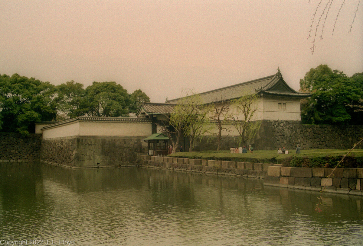
No trip to Tokyo could be complete without a visit to the Imperial Palace, and that was where I went on my second day in the city. It did not take a long time because only a few selected parts of the palace grounds are open to visitors.
For hundreds of years, until the Meiji Restoration of 1868, the Emperor resided in the old imperial capital of Kyoto. Tokyo, which was then known as Edo, was the seat of the Tokugawa shoguns, who resided in Edo Castle. With the ouster of the shogunate in 1868, the Emperor moved to Edo Castle, which became the new Imperial Palace.
The Meiji-era palace buildings were mostly destroyed by bombing in World War II, and new structures were constructed in the 1960s.


, c. 1913")


 at Kiyomizu-dera")


")

")
")


 side")
 side")